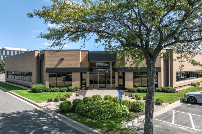
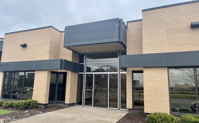
Property Record
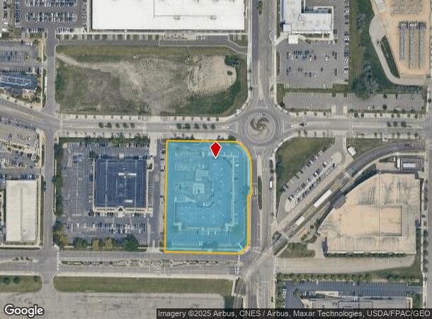
2700 E 82Nd St, Minneapolis, MN 55425
Current Lease Availabilities
NEARBY LISTINGS FOR SALE OR LEASE
Property Detail
2700 E 82Nd St
Minneapolis-St. Paul-Bloomington, MN-WI
Alpha Business Center 2Nd Addn
01-027-24-13-0012
LOT 002 BLOCK 001 A ALPHA BUSINESS CENTER 2ND ADDN EXCEPT LIGHT RAIL TRANSIT AND EXCEPT STREET IRREGULAR
Commercialnec
Hennepin
X
Minnesota
27053C0476F
2
2024
3.25 AC
2024
South Central
025100
Minneapolis/St Paul
30,900 SF
DEMOGRAPHICS near 2700 E 82Nd St
1 Mile
3 Mile
5 Mile
2024 Total Population
5,156
54,440
222,079
2029 Population
5,265
53,971
220,448
Pop Growth 2024-2029
+ 2.11%
(0.86%)
(0.73%)
Average Age
38
39
41
2024 Total Households
2,454
22,153
96,385
HH Growth 2024-2029
+ 2.69%
(0.75%)
(0.76%)
Median Household Inc
$75,707
$71,342
$81,508
Avg Household Size
2.10
2.30
2.20
2024 Avg HH Vehicles
1.00
2.00
2.00
Median Home Value
$282,866
$269,743
$314,417
Median Year Built
1991
1963
1966
Nearby Places
- Restaurants
- Banks
- Shops
- Fitness
- Groceries
PUBLIC TRANSPORTATION
TRANSIT/SUBWAY
28Th Avenue Station (Hiawatha Line - Minneapolis-Saint Paul Metro Transit Light Rail)
DRIVE
WALK
Distance
28Th Avenue Station (Hiawatha Line - Minneapolis-Saint Paul Metro Transit Light Rail)
0 min
3 min
0.2 mi
Bloomington Central Station (Hiawatha Line - Minneapolis-Saint Paul Metro Transit Light Rail)
DRIVE
WALK
Distance
Bloomington Central Station (Hiawatha Line - Minneapolis-Saint Paul Metro Transit Light Rail)
2 min
8 min
0.4 mi
Mall Of America Station (Hiawatha Line - Minneapolis-Saint Paul Metro Transit Light Rail)
DRIVE
WALK
Distance
Mall Of America Station (Hiawatha Line - Minneapolis-Saint Paul Metro Transit Light Rail)
3 min
9 min
0.5 mi
American Boulevard (Hiawatha Line - Minneapolis-Saint Paul Metro Transit Light Rail)
DRIVE
WALK
Distance
American Boulevard (Hiawatha Line - Minneapolis-Saint Paul Metro Transit Light Rail)
1 min
12 min
0.6 mi
AIRPORT
Minneapolis-St Paul International/Wold-Chamberlain
DRIVE
WALK
Distance
Minneapolis-St Paul International/Wold-Chamberlain
6 min
2.4 mi
Freight Ports
Port Milwaukee
DRIVE
WALK
Distance
Port Milwaukee
376 min
340.0 mi
Nearby Properties
Address
Land Use
TOTAL SIZE
Lot Size
Zoning
Address
Land Use
TOTAL SIZE
Lot Size
Zoning
1,233,880 SF
63.49 AC
Address
Land Use
TOTAL SIZE
Lot Size
Zoning
4.26 AC
Address
Land Use
TOTAL SIZE
Lot Size
Zoning
154,216 SF
0.81 AC
GLC3*
Address
Land Use
TOTAL SIZE
Lot Size
Zoning
3.86 AC
Address
Land Use
TOTAL SIZE
Lot Size
Zoning
752,064 SF
24.03 AC
Address
Land Use
TOTAL SIZE
Lot Size
Zoning
4.29 AC
Address
Land Use
TOTAL SIZE
Lot Size
Zoning
78,800 SF
2.12 AC
Address
Land Use
TOTAL SIZE
Lot Size
Zoning
4.20 AC
Address
Land Use
TOTAL SIZE
Lot Size
Zoning
98,676 SF
8.77 AC
Address
Land Use
TOTAL SIZE
Lot Size
Zoning
300,663 SF
4.81 AC
Address
Land Use
TOTAL SIZE
Lot Size
Zoning
114,617 SF
17.68 AC
Address
Land Use
TOTAL SIZE
Lot Size
Zoning
2.49 AC
Address
Land Use
TOTAL SIZE
Lot Size
Zoning
6.87 AC
Address
Land Use
TOTAL SIZE
Lot Size
Zoning
192,843 SF
13.32 AC
Address
Land Use
TOTAL SIZE
Lot Size
Zoning
4.20 AC
Address
Land Use
TOTAL SIZE
Lot Size
Zoning
33,246 SF
5.16 AC
Address
Land Use
TOTAL SIZE
Lot Size
Zoning
47,397 SF
6.78 AC
Address
Land Use
TOTAL SIZE
Lot Size
Zoning
Address
Land Use
TOTAL SIZE
Lot Size
Zoning
4.20 AC
Address
Land Use
TOTAL SIZE
Lot Size
Zoning
138,826 SF
23.39 AC
Address
Land Use
TOTAL SIZE
Lot Size
Zoning
14,568 SF
14.97 AC
Address
Land Use
TOTAL SIZE
Lot Size
Zoning
Address
Land Use
TOTAL SIZE
Lot Size
Zoning
Address
Land Use
TOTAL SIZE
Lot Size
Zoning
21,599 SF
37.46 AC
Address
Land Use
TOTAL SIZE
Lot Size
Zoning
Address
Land Use
TOTAL SIZE
Lot Size
Zoning
134,298 SF
16.70 AC
Address
Land Use
TOTAL SIZE
Lot Size
Zoning
34,152 SF
6.11 AC
Address
Land Use
TOTAL SIZE
Lot Size
Zoning
Address
Land Use
TOTAL SIZE
Lot Size
Zoning
26,838 SF
1.30 AC
Address
Land Use
TOTAL SIZE
Lot Size
Zoning
The World's #1 Commercial Real Estate Marketplace
Connect with us
© 2025 CoStar Group
The information above has been obtained from sources believed reliable. While we do not doubt its accuracy we have not verified it and make no guarantee, warranty or representation about it. It is your responsibility to independently confirm its accuracy and completeness. Any projections, opinions, assumptions, or estimates used are for example only and do not represent the current or future performance of the property. The value of this transaction to you depends on tax and other factors which should be evaluated by your tax, financial, and legal advisors. You and your advisors should conduct a careful, independent investigation of the property to determine to your satisfaction the suitability of the property for your needs.