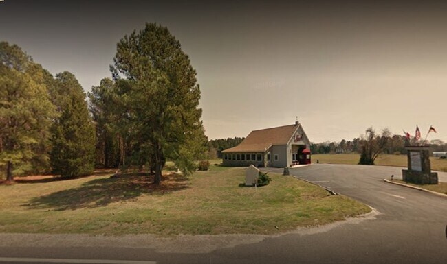
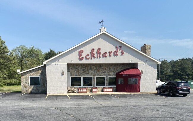
Property Record
2700 Greys Point Rd, Topping, VA 23169
NEARBY LISTINGS FOR SALE OR LEASE
-
-
View all Topping listings for sale on LoopNet.com
Property Detail
2700 Greys Point Rd
Commercialnec
LOCKLIES .851 AC D239-862,243-49,P12-215,06-2436 D11-1979,SL36-5,D16-1501
X
Middlesex
51119C0205F
Virginia
2025
0.85 AC
2025
Virginia Regional
951100
Other Market Areas
3,948 SF
30-104C
DEMOGRAPHICS near 2700 Greys Point Rd
1 Mile
3 Mile
5 Mile
2024 Total Population
483
1,757
6,401
2029 Population
501
1,834
6,591
Pop Growth 2024-2029
+ 3.73%
+ 4.38%
+ 2.97%
Average Age
47
48
50
2024 Total Households
222
792
2,901
HH Growth 2024-2029
+ 3.60%
+ 4.42%
+ 2.76%
Median Household Inc
$55,833
$61,990
$66,407
Avg Household Size
2.20
2.20
2.10
2024 Avg HH Vehicles
2.00
2.00
2.00
Median Home Value
$272,222
$278,229
$313,352
Median Year Built
1986
1986
1985
Nearby Places
Map Layers
Map Styles
 Street
 Aerial
- Restaurants
- Banks
- Shops
- Fitness
- Groceries
SALE & LEASE HISTORY
LISTING DATE
SALE/LEASE

May 04, 2021
For Sale
Feb 05, 2020
For Sale
Nearby Properties
Address
Land Use
TOTAL SIZE
Lot Size
Zoning
Address
Land Use
TOTAL SIZE
Lot Size
Zoning
4,088 SF
131.35 AC
WC
Address
Land Use
TOTAL SIZE
Lot Size
Zoning
760 SF
8.44 AC
WC
Address
Land Use
TOTAL SIZE
Lot Size
Zoning
62.63 AC
LDR
Address
Land Use
TOTAL SIZE
Lot Size
Zoning
1,344 SF
1.04 AC
WC
Address
Land Use
TOTAL SIZE
Lot Size
Zoning
10,880 SF
3.09 AC
LI
Address
Land Use
TOTAL SIZE
Lot Size
Zoning
9,600 SF
6.42 AC
LDR
Address
Land Use
TOTAL SIZE
Lot Size
Zoning
11.49 AC
LDR
Address
Land Use
TOTAL SIZE
Lot Size
Zoning
12,880 SF
1.30 AC
GB
Address
Land Use
TOTAL SIZE
Lot Size
Zoning
16,980 SF
8.10 AC
VC
Address
Land Use
TOTAL SIZE
Lot Size
Zoning
4,176 SF
6.61 AC
GB
Address
Land Use
TOTAL SIZE
Lot Size
Zoning
10,800 SF
3.15 AC
GB
Address
Land Use
TOTAL SIZE
Lot Size
Zoning
1,008 SF
0.47 AC
LDR
Address
Land Use
TOTAL SIZE
Lot Size
Zoning
1.88 AC
LI
Address
Land Use
TOTAL SIZE
Lot Size
Zoning
3.68 AC
LDR
Address
Land Use
TOTAL SIZE
Lot Size
Zoning
12,450 SF
1.12 AC
LI
Address
Land Use
TOTAL SIZE
Lot Size
Zoning
1.50 AC
LI
Address
Land Use
TOTAL SIZE
Lot Size
Zoning
3,692 SF
1.39 AC
LI
Address
Land Use
TOTAL SIZE
Lot Size
Zoning
1,357 SF
2.06 AC
LDR
Address
Land Use
TOTAL SIZE
Lot Size
Zoning
967 SF
0.50 AC
LDR
Address
Land Use
TOTAL SIZE
Lot Size
Zoning
5,984 SF
0.92 AC
GB
Address
Land Use
TOTAL SIZE
Lot Size
Zoning
4,500 SF
0.99 AC
LI
Address
Land Use
TOTAL SIZE
Lot Size
Zoning
5,289 SF
0.98 AC
GB
Address
Land Use
TOTAL SIZE
Lot Size
Zoning
1,538 SF
0.91 AC
LI
Address
Land Use
TOTAL SIZE
Lot Size
Zoning
0.41 AC
RE
Address
Land Use
TOTAL SIZE
Lot Size
Zoning
1,192 SF
2 AC
LDR
Address
Land Use
TOTAL SIZE
Lot Size
Zoning
1.37 AC
LI
Address
Land Use
TOTAL SIZE
Lot Size
Zoning
0.97 AC
LI
Address
Land Use
TOTAL SIZE
Lot Size
Zoning
2.80 AC
LDR
Address
Land Use
TOTAL SIZE
Lot Size
Zoning
2,342 SF
18.84 AC
GB
The World's #1 Commercial Real Estate Marketplace
Connect with us
© 2025 CoStar Group
The information above has been obtained from sources believed reliable. While we do not doubt its accuracy we have not verified it and make no guarantee, warranty or representation about it. It is your responsibility to independently confirm its accuracy and completeness. Any projections, opinions, assumptions, or estimates used are for example only and do not represent the current or future performance of the property. The value of this transaction to you depends on tax and other factors which should be evaluated by your tax, financial, and legal advisors. You and your advisors should conduct a careful, independent investigation of the property to determine to your satisfaction the suitability of the property for your needs.