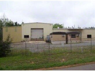
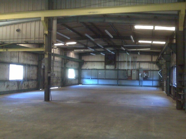
Property Record
2700 Mcdonald Ave, Ruston, LA 71270

Property Detail
2700 Mcdonald Ave
Ruston, LA
BEG AT SEC OF SEC 19-18-2 RUN N 00 DEG 49' W ALONG SEC LINE TO 1 PIPE SET ON S R/W LINE OF MCDONALD AVE FOR ST PT WHICH PT IS
5108
Lincoln
Warehouse
Louisiana
AE The base floodplain where base flood elevations are provided. AE Zones are now used on new format FIRMs instead of A1-A30 Zones.
25
2025
9.14 AC
2025
Louisiana North Area
960600
Other Market Areas
5,000 SF
NEARBY LISTINGS FOR SALE OR LEASE
DEMOGRAPHICS near 2700 Mcdonald Ave
1 mile
3 mile
5 mile
2025 Total Population
1,391
16,107
29,599
2030 Population
1,389
16,009
29,550
Pop Growth 2025-2030
(0.14%)
(0.61%)
(0.17%)
Average Age
39
36
35
2025 Total Households
581
6,679
11,428
HH Growth 2025-2030
(0.17%)
(0.60%)
(0.14%)
Median Household Inc
$29,735
$33,027
$36,570
Avg Household Size
2.20
2.30
2.30
2025 Avg HH Vehicles
2.00
2.00
2.00
Median Home Value
$96,999
$183,517
$222,941
Median Year Built
1978
1983
1986
Nearby Places
Map Layers
Map Styles
 Street
 Aerial
Layers
 Traffic
 Biking
Places
Listings with unknown addresses are not visible on the map
- Restaurants
- Banks
- Shops
- Fitness
- Groceries
PUBLIC TRANSPORTATION
AIRPORT
Monroe Regional
Drive
Walk
Distance
Monroe Regional
47 min
37.9 mi
SALE & LEASE HISTORY
LISTING DATE
SALE/LEASE

Sep 24, 2016
For Sale
Nearby Properties
Address
Land Use
TOTAL SIZE
Lot Size
Zoning
Address
Land Use
TOTAL SIZE
Lot Size
Zoning
225,000 SF
30 AC
Address
Land Use
TOTAL SIZE
Lot Size
Zoning
100,000 SF
Address
Land Use
TOTAL SIZE
Lot Size
Zoning
155,626 SF
13.18 AC
Address
Land Use
TOTAL SIZE
Lot Size
Zoning
206,447 SF
Address
Land Use
TOTAL SIZE
Lot Size
Zoning
17,028 SF
12.28 AC
Address
Land Use
TOTAL SIZE
Lot Size
Zoning
264,355 SF
20.26 AC
Address
Land Use
TOTAL SIZE
Lot Size
Zoning
25,184 SF
12.54 AC
Address
Land Use
TOTAL SIZE
Lot Size
Zoning
138,249 SF
4.89 AC
Address
Land Use
TOTAL SIZE
Lot Size
Zoning
66,930 SF
7.80 AC
Address
Land Use
TOTAL SIZE
Lot Size
Zoning
31,716 SF
4.99 AC
Address
Land Use
TOTAL SIZE
Lot Size
Zoning
110,675 SF
15.14 AC
Address
Land Use
TOTAL SIZE
Lot Size
Zoning
55,929 SF
3.35 AC
Address
Land Use
TOTAL SIZE
Lot Size
Zoning
88,229 SF
6.44 AC
Address
Land Use
TOTAL SIZE
Lot Size
Zoning
17,418 SF
11.16 AC
Address
Land Use
TOTAL SIZE
Lot Size
Zoning
24,348 SF
4.60 AC
Address
Land Use
TOTAL SIZE
Lot Size
Zoning
33,140 SF
2.79 AC
Address
Land Use
TOTAL SIZE
Lot Size
Zoning
56,560 SF
2.94 AC
Address
Land Use
TOTAL SIZE
Lot Size
Zoning
72,169 SF
19.84 AC
Address
Land Use
TOTAL SIZE
Lot Size
Zoning
52,824 SF
2.16 AC
Address
Land Use
TOTAL SIZE
Lot Size
Zoning
58,868 SF
6.46 AC
Address
Land Use
TOTAL SIZE
Lot Size
Zoning
43,738 SF
6.92 AC
Address
Land Use
TOTAL SIZE
Lot Size
Zoning
31,938 SF
9.36 AC
Address
Land Use
TOTAL SIZE
Lot Size
Zoning
51,976 SF
2.31 AC
Address
Land Use
TOTAL SIZE
Lot Size
Zoning
34,414 SF
3.87 AC
Address
Land Use
TOTAL SIZE
Lot Size
Zoning
42,885 SF
19.48 AC
Address
Land Use
TOTAL SIZE
Lot Size
Zoning
42,672 SF
3.30 AC
Address
Land Use
TOTAL SIZE
Lot Size
Zoning
45,984 SF
2.15 AC
Address
Land Use
TOTAL SIZE
Lot Size
Zoning
140,000 SF
10.31 AC
Address
Land Use
TOTAL SIZE
Lot Size
Zoning
14,384 SF
2.07 AC
Address
Land Use
TOTAL SIZE
Lot Size
Zoning
24,300 SF
2.55 AC
The World's #1 Commercial Real Estate Marketplace
Connect with us
© 2026 CoStar Group
The information above has been obtained from sources believed reliable. While we do not doubt its accuracy we have not verified it and make no guarantee, warranty or representation about it. It is your responsibility to independently confirm its accuracy and completeness. Any projections, opinions, assumptions, or estimates used are for example only and do not represent the current or future performance of the property. The value of this transaction to you depends on tax and other factors which should be evaluated by your tax, financial, and legal advisors. You and your advisors should conduct a careful, independent investigation of the property to determine to your satisfaction the suitability of the property for your needs.