Property Record
2700 Ridge Point Dr, High Ridge, MO 63049

NEARBY LISTINGS FOR SALE OR LEASE
Property Detail
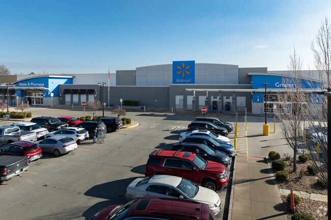
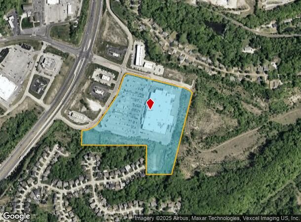
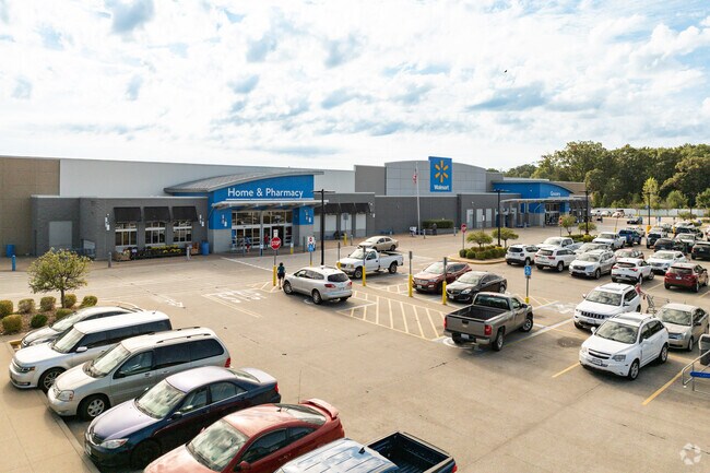
2700 Ridge Point Dr
St. Louis, MO-IL
High Ridge Commons Commercial
03-6.0-13.0-4-001-003.06
HIGH RIDGE COMMONS COMMERCIAL LOT 1
Departmentstore
Jefferson
X
Missouri
29099C0084F
1
2024
22.76 AC
2025
Southwest County
700211
St. Louis
155,242 SF
DEMOGRAPHICS near 2700 Ridge Point Dr
1 Mile
3 Mile
5 Mile
2024 Total Population
4,550
23,585
67,707
2029 Population
4,688
24,351
68,946
Pop Growth 2024-2029
+ 3.03%
+ 3.25%
+ 1.83%
Average Age
41
41
41
2024 Total Households
1,845
9,302
25,991
HH Growth 2024-2029
+ 3.04%
+ 3.31%
+ 1.95%
Median Household Inc
$71,385
$73,265
$77,469
Avg Household Size
2.40
2.50
2.60
2024 Avg HH Vehicles
2.00
2.00
2.00
Median Home Value
$180,285
$199,789
$230,233
Median Year Built
1980
1983
1985
Nearby Places
Map Layers
Map Styles
 Street
 Aerial
- Restaurants
- Banks
- Shops
- Fitness
- Groceries
PUBLIC TRANSPORTATION
AIRPORT
St Louis Lambert International
DRIVE
WALK
Distance
St Louis Lambert International
43 min
29.4 mi
Freight Ports
Tulsa Port of Inola
DRIVE
WALK
Distance
Tulsa Port of Inola
409 min
364.3 mi
SALE & LEASE HISTORY
LISTING DATE
SALE/LEASE

Apr 10, 2017
For Lease
Nearby Properties
Address
Land Use
TOTAL SIZE
Lot Size
Zoning
Address
Land Use
TOTAL SIZE
Lot Size
Zoning
258,312 SF
16.34 AC
CC2
Address
Land Use
TOTAL SIZE
Lot Size
Zoning
108,535 SF
14.09 AC
PUD
Address
Land Use
TOTAL SIZE
Lot Size
Zoning
186,525 SF
20.80 AC
R20
Address
Land Use
TOTAL SIZE
Lot Size
Zoning
30,189 SF
7.80 AC
CC2
Address
Land Use
TOTAL SIZE
Lot Size
Zoning
1,910 SF
5.19 AC
R40
Address
Land Use
TOTAL SIZE
Lot Size
Zoning
273,663 SF
18.81 AC
R09
Address
Land Use
TOTAL SIZE
Lot Size
Zoning
108,211 SF
15.18 AC
PI
Address
Land Use
TOTAL SIZE
Lot Size
Zoning
76,636 SF
8.41 AC
CC2
Address
Land Use
TOTAL SIZE
Lot Size
Zoning
31,193 SF
4.52 AC
CC2
Address
Land Use
TOTAL SIZE
Lot Size
Zoning
57,518 SF
4.88 AC
R09
Address
Land Use
TOTAL SIZE
Lot Size
Zoning
22,768 SF
2.91 AC
Address
Land Use
TOTAL SIZE
Lot Size
Zoning
75,099 SF
2.74 AC
CC2
Address
Land Use
TOTAL SIZE
Lot Size
Zoning
93,250 SF
2.63 AC
PUD
Address
Land Use
TOTAL SIZE
Lot Size
Zoning
14,612 SF
2.19 AC
CC2
Address
Land Use
TOTAL SIZE
Lot Size
Zoning
15,064 SF
2.34 AC
CC2
Address
Land Use
TOTAL SIZE
Lot Size
Zoning
85,156 SF
9.27 AC
CC2
Address
Land Use
TOTAL SIZE
Lot Size
Zoning
39,276 SF
4.93 AC
CC2
Address
Land Use
TOTAL SIZE
Lot Size
Zoning
30,896 SF
6.01 AC
CC2
Address
Land Use
TOTAL SIZE
Lot Size
Zoning
50,353 SF
2.59 AC
CC2
Address
Land Use
TOTAL SIZE
Lot Size
Zoning
51,166 SF
6.09 AC
CC2
Address
Land Use
TOTAL SIZE
Lot Size
Zoning
4,514 SF
1.76 AC
CC2
Address
Land Use
TOTAL SIZE
Lot Size
Zoning
6,488 SF
1.06 AC
PUD
Address
Land Use
TOTAL SIZE
Lot Size
Zoning
31,680 SF
1.45 AC
PI
Address
Land Use
TOTAL SIZE
Lot Size
Zoning
4,392 SF
1.71 AC
Address
Land Use
TOTAL SIZE
Lot Size
Zoning
3,426 SF
1.76 AC
Address
Land Use
TOTAL SIZE
Lot Size
Zoning
2,340 SF
1.67 AC
CC2
Address
Land Use
TOTAL SIZE
Lot Size
Zoning
4,476 SF
1.37 AC
PUD
Address
Land Use
TOTAL SIZE
Lot Size
Zoning
11,484 SF
2.11 AC
CC2
Address
Land Use
TOTAL SIZE
Lot Size
Zoning
54,575 SF
3.78 AC
CC2
The World's #1 Commercial Real Estate Marketplace
Connect with us
© 2026 CoStar Group
The information above has been obtained from sources believed reliable. While we do not doubt its accuracy we have not verified it and make no guarantee, warranty or representation about it. It is your responsibility to independently confirm its accuracy and completeness. Any projections, opinions, assumptions, or estimates used are for example only and do not represent the current or future performance of the property. The value of this transaction to you depends on tax and other factors which should be evaluated by your tax, financial, and legal advisors. You and your advisors should conduct a careful, independent investigation of the property to determine to your satisfaction the suitability of the property for your needs.