Property Record
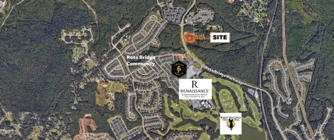
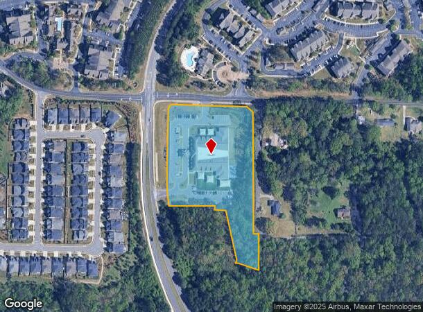
2700 Ross Bridge Pkwy, Hoover, AL 35226
NEARBY LISTINGS FOR SALE OR LEASE
Property Detail
2700 Ross Bridge Pkwy
39-00-07-1-000-001.009
Bdry Of Ross Bridge 1St
Publichealthcarefacility
COM AT NE COR OF SE1/4 OF NE 1/4 OF SEC 7 TWSP 19S R 3W TH S 30 FT TO POB TH S 729.4 FT TH NW 100.4 FT TH NWLY 177 FT TH SW 104.7 FT TO PT ON E BDRY OF ROSS BRIDGE 1ST SEC 40/37 R/W TH NWLY & ALG A CURVE 472 FT TH CONT ALG R/W IN A NLY DIRECTION 256.
X
Jefferson
01073C0544J
Alabama
2023
7 AC
2024
Bessemer
014304
Birmingham
27,760 SF
Birmingham-Hoover, AL
DEMOGRAPHICS near 2700 Ross Bridge Pkwy
1 Mile
3 Mile
5 Mile
2024 Total Population
4,679
25,315
104,215
2029 Population
4,551
24,629
102,264
Pop Growth 2024-2029
(2.74%)
(2.71%)
(1.87%)
Average Age
37
39
39
2024 Total Households
1,809
9,991
42,444
HH Growth 2024-2029
(2.93%)
(2.77%)
(1.98%)
Median Household Inc
$110,833
$91,914
$61,645
Avg Household Size
2.50
2.50
2.40
2024 Avg HH Vehicles
2.00
2.00
2.00
Median Home Value
$418,213
$326,483
$268,549
Median Year Built
2009
1998
1978
Nearby Places
Map Layers
Map Styles
 Street
 Aerial
- Restaurants
- Banks
- Shops
- Fitness
- Groceries
PUBLIC TRANSPORTATION
AIRPORT
Birmingham-Shuttlesworth International
DRIVE
WALK
Distance
Birmingham-Shuttlesworth International
29 min
16.4 mi
Freight Ports
Port of Mobile
DRIVE
WALK
Distance
Port of Mobile
285 min
256.4 mi
SALE & LEASE HISTORY
LISTING DATE
SALE/LEASE

Jan 29, 2024
For Sale
Dec 18, 2019
For Sale
Nearby Properties
Address
Land Use
TOTAL SIZE
Lot Size
Zoning
Address
Land Use
TOTAL SIZE
Lot Size
Zoning
143,148 SF
15.60 AC
CP
Address
Land Use
TOTAL SIZE
Lot Size
Zoning
929,435 SF
58 AC
I4
Address
Land Use
TOTAL SIZE
Lot Size
Zoning
242,746 SF
20.96 AC
MXDE
Address
Land Use
TOTAL SIZE
Lot Size
Zoning
209,765 SF
19.20 AC
I-3
Address
Land Use
TOTAL SIZE
Lot Size
Zoning
75,840 SF
20.10 AC
I3
Address
Land Use
TOTAL SIZE
Lot Size
Zoning
197,717 SF
19.02 AC
PUD
Address
Land Use
TOTAL SIZE
Lot Size
Zoning
321,783 SF
19.40 AC
MXD
Address
Land Use
TOTAL SIZE
Lot Size
Zoning
224,184 SF
65.60 AC
I3
Address
Land Use
TOTAL SIZE
Lot Size
Zoning
149,299 SF
15.70 AC
PUD
Address
Land Use
TOTAL SIZE
Lot Size
Zoning
231,385 SF
50.40 AC
R6
Address
Land Use
TOTAL SIZE
Lot Size
Zoning
120,238 SF
10 AC
I3
Address
Land Use
TOTAL SIZE
Lot Size
Zoning
246,696 SF
13.89 AC
R4
Address
Land Use
TOTAL SIZE
Lot Size
Zoning
118,309 SF
88.50 AC
I3
Address
Land Use
TOTAL SIZE
Lot Size
Zoning
96,446 SF
10 AC
I3
Address
Land Use
TOTAL SIZE
Lot Size
Zoning
51,572 SF
494.91 AC
I3
Address
Land Use
TOTAL SIZE
Lot Size
Zoning
187,200 SF
22 AC
I3
Address
Land Use
TOTAL SIZE
Lot Size
Zoning
202,775 SF
10.40 AC
I3
Address
Land Use
TOTAL SIZE
Lot Size
Zoning
72,468 SF
8.70 AC
I3
Address
Land Use
TOTAL SIZE
Lot Size
Zoning
73,033 SF
15.20 AC
R-6
Address
Land Use
TOTAL SIZE
Lot Size
Zoning
194,260 SF
11.58 AC
CM1A
Address
Land Use
TOTAL SIZE
Lot Size
Zoning
155,030 SF
10.30 AC
R4
Address
Land Use
TOTAL SIZE
Lot Size
Zoning
35,826 SF
3.77 AC
I-3
Address
Land Use
TOTAL SIZE
Lot Size
Zoning
68,191 SF
16.20 AC
I3
Address
Land Use
TOTAL SIZE
Lot Size
Zoning
68,191 SF
12.50 AC
I3
Address
Land Use
TOTAL SIZE
Lot Size
Zoning
88.50 AC
I3
Address
Land Use
TOTAL SIZE
Lot Size
Zoning
85,552 SF
6 AC
INST
Address
Land Use
TOTAL SIZE
Lot Size
Zoning
48,320 SF
7.81 AC
I3
Address
Land Use
TOTAL SIZE
Lot Size
Zoning
99,900 SF
6.22 AC
CM1A
Address
Land Use
TOTAL SIZE
Lot Size
Zoning
108,838 SF
10.80 AC
C2-C
The World's #1 Commercial Real Estate Marketplace
Connect with us
© 2025 CoStar Group
The information above has been obtained from sources believed reliable. While we do not doubt its accuracy we have not verified it and make no guarantee, warranty or representation about it. It is your responsibility to independently confirm its accuracy and completeness. Any projections, opinions, assumptions, or estimates used are for example only and do not represent the current or future performance of the property. The value of this transaction to you depends on tax and other factors which should be evaluated by your tax, financial, and legal advisors. You and your advisors should conduct a careful, independent investigation of the property to determine to your satisfaction the suitability of the property for your needs.