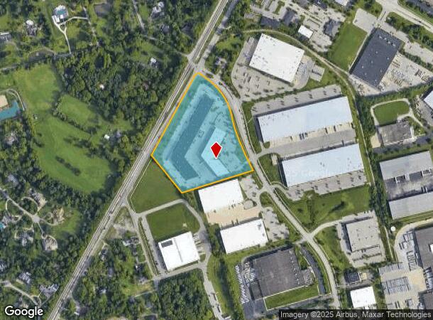
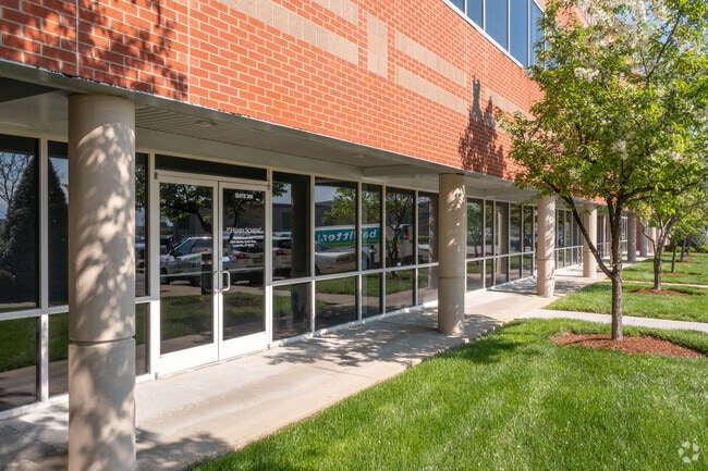
Property Record
2600 Stanley Gault Pky, Louisville, KY 40223

NEARBY LISTINGS FOR SALE OR LEASE
Property Detail
2600 Stanley Gault Pky
001502830000
11.252AC LAGRANGE RD
Commercialbuilding
Jefferson
X
Kentucky
21111C0033F
11.25 AC
2024
Hurstbourne/Lyndon
2024
Louisville
010406
Louisville-Jefferson County, KY-IN
55,583 SF
DEMOGRAPHICS near 2600 Stanley Gault Pky
1 Mile
3 Mile
5 Mile
2024 Total Population
1,882
51,445
133,114
2029 Population
1,863
51,166
133,244
Pop Growth 2024-2029
(1.01%)
(0.54%)
+ 0.10%
Average Age
41
41
41
2024 Total Households
703
20,913
54,571
HH Growth 2024-2029
(0.85%)
(0.66%)
(0.12%)
Median Household Inc
$136,789
$94,842
$96,200
Avg Household Size
2.60
2.40
2.40
2024 Avg HH Vehicles
2.00
2.00
2.00
Median Home Value
$573,958
$325,235
$331,020
Median Year Built
1990
1993
1992
Nearby Places
- Restaurants
- Banks
- Shops
- Fitness
- Groceries
PUBLIC TRANSPORTATION
AIRPORT
Louisville Muhammad Ali International
DRIVE
WALK
Distance
Louisville Muhammad Ali International
35 min
19.4 mi
Freight Ports
Port of Toledo
DRIVE
WALK
Distance
Port of Toledo
344 min
294.3 mi
SALE & LEASE HISTORY
LISTING DATE
SALE/LEASE

Feb 17, 2021
For Lease
Aug 28, 2024
For Lease
Nearby Properties
Address
Land Use
TOTAL SIZE
Lot Size
Zoning
Address
Land Use
TOTAL SIZE
Lot Size
Zoning
160,000 SF
421.24 AC
PEC-PLANNE
Address
Land Use
TOTAL SIZE
Lot Size
Zoning
9.74 AC
Address
Land Use
TOTAL SIZE
Lot Size
Zoning
11.92 AC
OTF-OFFICE
Address
Land Use
TOTAL SIZE
Lot Size
Zoning
3,172 SF
17.51 AC
R1-RESIDEN
Address
Land Use
TOTAL SIZE
Lot Size
Zoning
2,922 SF
23.24 AC
R4-RESIDEN
Address
Land Use
TOTAL SIZE
Lot Size
Zoning
4,940 SF
17.11 AC
R4-RESIDEN
Address
Land Use
TOTAL SIZE
Lot Size
Zoning
20.07 AC
Address
Land Use
TOTAL SIZE
Lot Size
Zoning
31.03 AC
C1-COMMERC
Address
Land Use
TOTAL SIZE
Lot Size
Zoning
17,628 SF
19.19 AC
R7-RESIDEN
Address
Land Use
TOTAL SIZE
Lot Size
Zoning
21,340 SF
17.43 AC
R7-RESIDEN
Address
Land Use
TOTAL SIZE
Lot Size
Zoning
2,793 SF
12.49 AC
R4-RESIDEN
Address
Land Use
TOTAL SIZE
Lot Size
Zoning
Address
Land Use
TOTAL SIZE
Lot Size
Zoning
15.48 AC
R4-RESIDEN
Address
Land Use
TOTAL SIZE
Lot Size
Zoning
142,751 SF
48.49 AC
PEC-PLANNE
Address
Land Use
TOTAL SIZE
Lot Size
Zoning
11,484 SF
13.83 AC
R7-RESIDEN
Address
Land Use
TOTAL SIZE
Lot Size
Zoning
2,094 SF
20.57 AC
R4-RESIDEN
Address
Land Use
TOTAL SIZE
Lot Size
Zoning
4,560 SF
24.41 AC
R6-RESIDEN
Address
Land Use
TOTAL SIZE
Lot Size
Zoning
62,500 SF
59.16 AC
PEC-PLANNE
Address
Land Use
TOTAL SIZE
Lot Size
Zoning
699,508 SF
55.04 AC
PEC-PLANNE
Address
Land Use
TOTAL SIZE
Lot Size
Zoning
20.36 AC
PEC-PLANNE
Address
Land Use
TOTAL SIZE
Lot Size
Zoning
27,471 SF
13.24 AC
R7-RESIDEN
Address
Land Use
TOTAL SIZE
Lot Size
Zoning
17,352 SF
10.86 AC
R7-RESIDEN
Address
Land Use
TOTAL SIZE
Lot Size
Zoning
17.80 AC
Address
Land Use
TOTAL SIZE
Lot Size
Zoning
1,093 SF
8.62 AC
R4-RESIDEN
Address
Land Use
TOTAL SIZE
Lot Size
Zoning
121,707 SF
8.95 AC
Address
Land Use
TOTAL SIZE
Lot Size
Zoning
Address
Land Use
TOTAL SIZE
Lot Size
Zoning
4,267 SF
10.13 AC
R6-RESIDEN
Address
Land Use
TOTAL SIZE
Lot Size
Zoning
62,840 SF
29.42 AC
PEC-PLANNE
Address
Land Use
TOTAL SIZE
Lot Size
Zoning
Address
Land Use
TOTAL SIZE
Lot Size
Zoning
158,310 SF
7.91 AC
OR3-OFFICE
The World's #1 Commercial Real Estate Marketplace
Connect with us
© 2025 CoStar Group
The information above has been obtained from sources believed reliable. While we do not doubt its accuracy we have not verified it and make no guarantee, warranty or representation about it. It is your responsibility to independently confirm its accuracy and completeness. Any projections, opinions, assumptions, or estimates used are for example only and do not represent the current or future performance of the property. The value of this transaction to you depends on tax and other factors which should be evaluated by your tax, financial, and legal advisors. You and your advisors should conduct a careful, independent investigation of the property to determine to your satisfaction the suitability of the property for your needs.