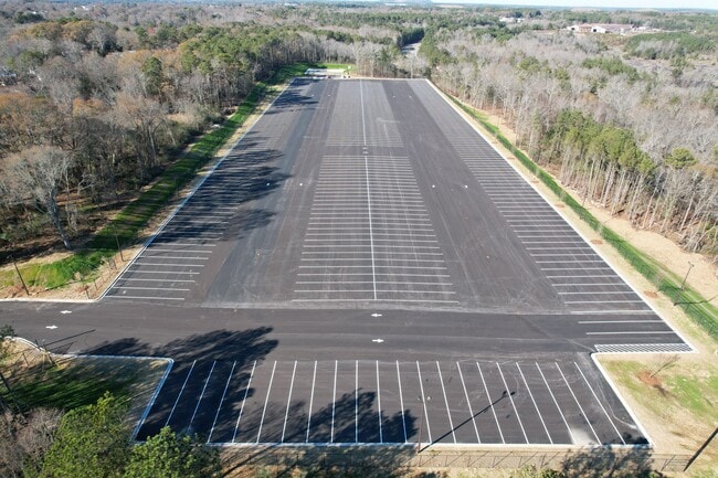
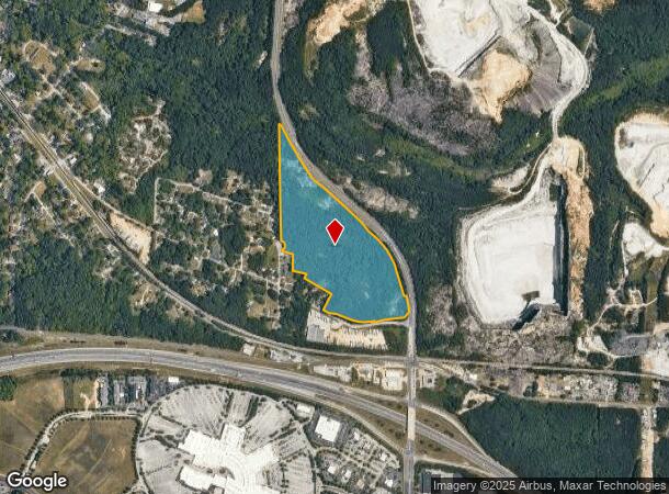
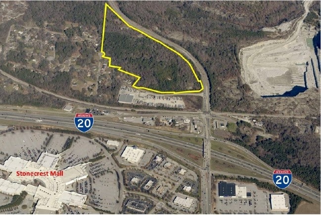
Property Record
2700 Turner Hill Rd, Lithonia, GA 30058

Current Lease Availabilities
NEARBY LISTINGS FOR SALE OR LEASE
Property Detail
2700 Turner Hill Rd
Atlanta-Sandy Springs-Roswell, GA
Mcphail Properties
16-169-01-026
50 X 105 X 157 X 314 X 159 X 107 X 151 X 155 X 350 X 151 X 233 40.17AC 3-28-88 26 X 105 X 157 X 314 X 159 X 107 39.72AC 10-9-
Truckterminal
DeKalb
AE
Georgia
13247C0080D
26
2025
38.94 AC
2025
I-20 East/Conyers
023313
Atlanta
DEMOGRAPHICS near 2700 Turner Hill Rd
1 Mile
3 Mile
5 Mile
2024 Total Population
1,160
33,983
111,896
2029 Population
1,200
34,306
112,529
Pop Growth 2024-2029
+ 3.45%
+ 0.95%
+ 0.57%
Average Age
39
37
38
2024 Total Households
451
13,110
40,829
HH Growth 2024-2029
+ 3.33%
+ 0.70%
+ 0.44%
Median Household Inc
$21,428
$60,834
$62,170
Avg Household Size
2.50
2.50
2.70
2024 Avg HH Vehicles
1.00
2.00
2.00
Median Home Value
$67,177
$198,537
$188,490
Median Year Built
1973
1995
1993
Nearby Places
- Restaurants
- Banks
- Shops
- Fitness
- Groceries
PUBLIC TRANSPORTATION
AIRPORT
Hartsfield - Jackson Atlanta International
DRIVE
WALK
Distance
Hartsfield - Jackson Atlanta International
33 min
23.2 mi
Freight Ports
Georgia Ports - Savannah
DRIVE
WALK
Distance
Georgia Ports - Savannah
281 min
242.5 mi
Nearby Properties
Address
Land Use
TOTAL SIZE
Lot Size
Zoning
Address
Land Use
TOTAL SIZE
Lot Size
Zoning
614,505 SF
97.30 AC
Address
Land Use
TOTAL SIZE
Lot Size
Zoning
764,622 SF
48.38 AC
M
Address
Land Use
TOTAL SIZE
Lot Size
Zoning
224,892 SF
17.81 AC
RM100
Address
Land Use
TOTAL SIZE
Lot Size
Zoning
257,807 SF
29.13 AC
RM100
Address
Land Use
TOTAL SIZE
Lot Size
Zoning
274,631 SF
25.67 AC
RM100
Address
Land Use
TOTAL SIZE
Lot Size
Zoning
235,521 SF
15.36 AC
RM75
Address
Land Use
TOTAL SIZE
Lot Size
Zoning
224,155 SF
22.58 AC
X
Address
Land Use
TOTAL SIZE
Lot Size
Zoning
118,007 SF
14.31 AC
Address
Land Use
TOTAL SIZE
Lot Size
Zoning
314,474 SF
24.04 AC
RM75
Address
Land Use
TOTAL SIZE
Lot Size
Zoning
405,288 SF
28.89 AC
C1
Address
Land Use
TOTAL SIZE
Lot Size
Zoning
81,537 SF
9.27 AC
C1
Address
Land Use
TOTAL SIZE
Lot Size
Zoning
2,782 SF
29.51 AC
R3/C
Address
Land Use
TOTAL SIZE
Lot Size
Zoning
194,186 SF
18.48 AC
RM100
Address
Land Use
TOTAL SIZE
Lot Size
Zoning
290,616 SF
23.84 AC
M-1
Address
Land Use
TOTAL SIZE
Lot Size
Zoning
1,810 SF
234.33 AC
RA8
Address
Land Use
TOTAL SIZE
Lot Size
Zoning
28,024 SF
11.24 AC
R1
Address
Land Use
TOTAL SIZE
Lot Size
Zoning
267,899 SF
47.90 AC
X
Address
Land Use
TOTAL SIZE
Lot Size
Zoning
283,988 SF
29 AC
RM100
Address
Land Use
TOTAL SIZE
Lot Size
Zoning
140,058 SF
8.46 AC
C1
Address
Land Use
TOTAL SIZE
Lot Size
Zoning
20,964 SF
25.29 AC
R3/C
Address
Land Use
TOTAL SIZE
Lot Size
Zoning
263,339 SF
24.24 AC
C1
Address
Land Use
TOTAL SIZE
Lot Size
Zoning
198,140 SF
18 AC
RM100
Address
Land Use
TOTAL SIZE
Lot Size
Zoning
218,152 SF
18.80 AC
RM100
Address
Land Use
TOTAL SIZE
Lot Size
Zoning
36,951 SF
8 AC
Address
Land Use
TOTAL SIZE
Lot Size
Zoning
138,876 SF
20 AC
RM100
Address
Land Use
TOTAL SIZE
Lot Size
Zoning
173,427 SF
15.18 AC
X
Address
Land Use
TOTAL SIZE
Lot Size
Zoning
7,384 SF
15.80 AC
M
Address
Land Use
TOTAL SIZE
Lot Size
Zoning
215,422 SF
33.84 AC
M
Address
Land Use
TOTAL SIZE
Lot Size
Zoning
227,648 SF
14.56 AC
X
Address
Land Use
TOTAL SIZE
Lot Size
Zoning
152,302 SF
17.91 AC
X
The World's #1 Commercial Real Estate Marketplace
Connect with us
© 2025 CoStar Group
The information above has been obtained from sources believed reliable. While we do not doubt its accuracy we have not verified it and make no guarantee, warranty or representation about it. It is your responsibility to independently confirm its accuracy and completeness. Any projections, opinions, assumptions, or estimates used are for example only and do not represent the current or future performance of the property. The value of this transaction to you depends on tax and other factors which should be evaluated by your tax, financial, and legal advisors. You and your advisors should conduct a careful, independent investigation of the property to determine to your satisfaction the suitability of the property for your needs.