Property Record
27005 76Th Ave, New Hyde Park, NY 11040


Save to a Folder
{{folder.Name}}
{{folder.ListingIds.length}} Properties
{{folder.ListingIds.length}} Property
Create a New Folder
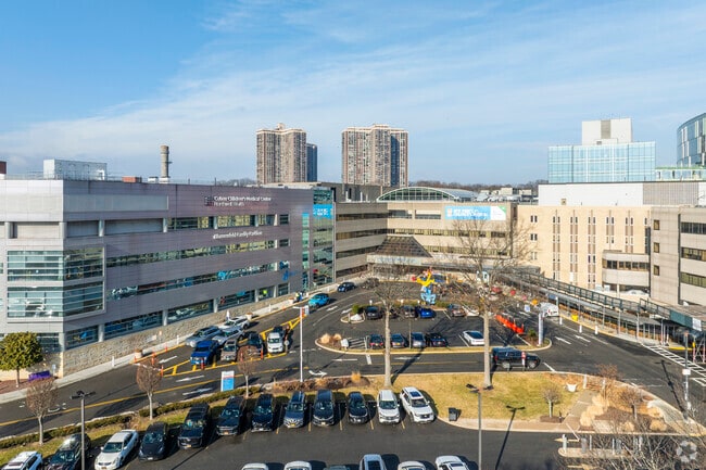
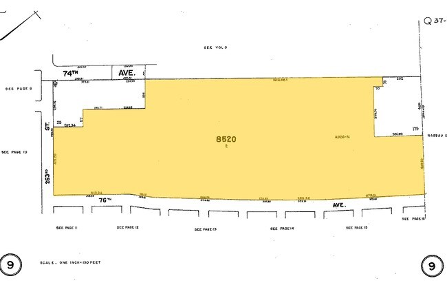
Property Detail
27005 76Th Ave
08520-0002
Queens
Hospitalpublic
New York
R3-2
2
B and X Area of moderate flood hazard, usually the area between the limits of the 100-year and 500-year floods.
30 AC
0
South Queens
2026
Long Island (New York)
155104
New York-Jersey City-White Plains, NY-NJ
1,667,567 SF
NEARBY LISTINGS FOR SALE OR LEASE
-
-
View all New Hyde Park listings for sale on LoopNet.com
DEMOGRAPHICS near 27005 76Th Ave
1 mile
3 mile
5 mile
2025 Total Population
25,027
236,271
665,612
2030 Population
24,875
234,724
658,322
Pop Growth 2025-2030
(0.61%)
(0.65%)
(1.10%)
Average Age
50
45
44
2025 Total Households
9,717
81,983
222,664
HH Growth 2025-2030
(1.21%)
(0.94%)
(1.34%)
Median Household Inc
$114,140
$122,342
$119,420
Avg Household Size
2.40
2.80
2.90
2025 Avg HH Vehicles
1.00
2.00
2.00
Median Home Value
$649,292
$762,594
$786,794
Median Year Built
1956
1953
1952
Nearby Places
Map Layers
Map Styles
 Street
 Aerial
Layers
 Traffic
 Biking
Places
Listings with unknown addresses are not visible on the map
- Restaurants
- Banks
- Shops
- Fitness
- Groceries
PUBLIC TRANSPORTATION
COMMUTER RAIL
New Hyde Park Station (Port Jefferson Branch - Long Island Rail Road)
Drive
Walk
Distance
New Hyde Park Station (Port Jefferson Branch - Long Island Rail Road)
5 min
2.4 mi
Floral Park Station (Hempstead Branch - Long Island Rail Road)
Drive
Walk
Distance
Floral Park Station (Hempstead Branch - Long Island Rail Road)
6 min
2.9 mi
AIRPORT
John F Kennedy International
Drive
Walk
Distance
John F Kennedy International
21 min
12.2 mi
LaGuardia
Drive
Walk
Distance
LaGuardia
21 min
12.4 mi
Westchester County
Drive
Walk
Distance
Westchester County
50 min
33.6 mi
Freight Ports
NY - Red Hook Container Terminal
Drive
Walk
Distance
NY - Red Hook Container Terminal
32 min
20.5 mi
Nearby Properties
Address
Land Use
TOTAL SIZE
Lot Size
Zoning
Address
Land Use
TOTAL SIZE
Lot Size
Zoning
2,697,663 SF
3.46 AC
C5-3
Address
Land Use
TOTAL SIZE
Lot Size
Zoning
1,666,696 SF
1.87 AC
C52.5
Address
Land Use
TOTAL SIZE
Lot Size
Zoning
7,975 SF
133 AC
PARK
Address
Land Use
TOTAL SIZE
Lot Size
Zoning
986,724 SF
89.79 AC
R3-2
Address
Land Use
TOTAL SIZE
Lot Size
Zoning
878,386 SF
20.55 AC
R4
Address
Land Use
TOTAL SIZE
Lot Size
Zoning
800 SF
104.61 AC
PARK
Address
Land Use
TOTAL SIZE
Lot Size
Zoning
202,459 SF
82.16 AC
R3-2
Address
Land Use
TOTAL SIZE
Lot Size
Zoning
448,500 SF
22.59 AC
R3-2
Address
Land Use
TOTAL SIZE
Lot Size
Zoning
636,219 SF
11.39 AC
R3-2
Address
Land Use
TOTAL SIZE
Lot Size
Zoning
900 SF
86.35 AC
PARK
Address
Land Use
TOTAL SIZE
Lot Size
Zoning
511,684 SF
13.09 AC
R4
Address
Land Use
TOTAL SIZE
Lot Size
Zoning
1,800 SF
54.60 AC
PARK
Address
Land Use
TOTAL SIZE
Lot Size
Zoning
201,770 SF
7.09 AC
R3-2
Address
Land Use
TOTAL SIZE
Lot Size
Zoning
268,500 SF
27.50 AC
R4
Address
Land Use
TOTAL SIZE
Lot Size
Zoning
32,000 SF
50 AC
PARK
Address
Land Use
TOTAL SIZE
Lot Size
Zoning
344,292 SF
12.56 AC
R4
Address
Land Use
TOTAL SIZE
Lot Size
Zoning
7,030 SF
12.43 AC
R3-2
Address
Land Use
TOTAL SIZE
Lot Size
Zoning
95.36 AC
PARK
Address
Land Use
TOTAL SIZE
Lot Size
Zoning
111,122 SF
8.94 AC
R3-2
Address
Land Use
TOTAL SIZE
Lot Size
Zoning
231,865 SF
9.99 AC
C4-1
Address
Land Use
TOTAL SIZE
Lot Size
Zoning
123,832 SF
5.29 AC
R3-2
Address
Land Use
TOTAL SIZE
Lot Size
Zoning
356,093 SF
3 AC
R3-2
Address
Land Use
TOTAL SIZE
Lot Size
Zoning
171,000 SF
2.76 AC
R2A
Address
Land Use
TOTAL SIZE
Lot Size
Zoning
99,814 SF
1.31 AC
R3-2
Address
Land Use
TOTAL SIZE
Lot Size
Zoning
185,328 SF
2.69 AC
R5
Address
Land Use
TOTAL SIZE
Lot Size
Zoning
142,000 SF
2.38 AC
R3-2
Address
Land Use
TOTAL SIZE
Lot Size
Zoning
161,500 SF
3.44 AC
R3-2
Address
Land Use
TOTAL SIZE
Lot Size
Zoning
11.30 AC
PARK
Address
Land Use
TOTAL SIZE
Lot Size
Zoning
400 SF
25.80 AC
PARK
The World's #1 Commercial Real Estate Marketplace
Connect with us
© 2026 CoStar Group
The information above has been obtained from sources believed reliable. While we do not doubt its accuracy we have not verified it and make no guarantee, warranty or representation about it. It is your responsibility to independently confirm its accuracy and completeness. Any projections, opinions, assumptions, or estimates used are for example only and do not represent the current or future performance of the property. The value of this transaction to you depends on tax and other factors which should be evaluated by your tax, financial, and legal advisors. You and your advisors should conduct a careful, independent investigation of the property to determine to your satisfaction the suitability of the property for your needs.