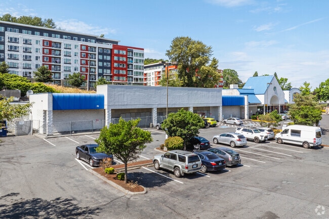
Property Record
2701 Rainier Ave S, Seattle, WA 98144


Current Lease Availabilities
NEARBY LISTINGS FOR SALE OR LEASE
Property Detail
2701 Rainier Ave S
Seattle-Tacoma-Bellevue, WA
Mc Arthurs Add
526030-0005
MC ARTHURS ADD ALL BLK 1 & ALL BLK 6 & VAC ALLEY & ST LY BET BLKS 1 & 6 LESS SEWER IN BLK 6
Regionalshoppingcenterormallwithanchorstore
King
X
Washington
53033C0635G
pors
2025
3.24 AC
2024
S Seattle
009500
Seattle/Puget Sound
50,785 SF
DEMOGRAPHICS near 2701 Rainier Ave S
1 Mile
3 Mile
5 Mile
2024 Total Population
25,539
175,070
431,562
2029 Population
26,108
178,985
439,334
Pop Growth 2024-2029
+ 2.23%
+ 2.24%
+ 1.80%
Average Age
40
39
39
2024 Total Households
10,393
84,490
211,399
HH Growth 2024-2029
+ 2.06%
+ 2.37%
+ 1.90%
Median Household Inc
$107,099
$97,435
$113,301
Avg Household Size
2.30
1.90
1.90
2024 Avg HH Vehicles
1.00
1.00
1.00
Median Home Value
$844,679
$853,043
$892,640
Median Year Built
1966
1983
1984
Nearby Places
Map Layers
Map Styles
 Street
 Aerial
- Restaurants
- Banks
- Shops
- Fitness
- Groceries
PUBLIC TRANSPORTATION
TRANSIT/SUBWAY
ST Light Rail & Mount Baker Station (NB) (LINK to Sea-Tac - Central Puget Sound Regional Transit Authority Rail (Link Light Rail/Sounder))
DRIVE
WALK
Distance
ST Light Rail & Mount Baker Station (NB) (LINK to Sea-Tac - Central Puget Sound Regional Transit Authority Rail (Link Light Rail/Sounder))
1 min
4 min
0.2 mi
Mount Baker (Central Link - Central Puget Sound Regional Transit Authority Rail (Link Light Rail/Sounder))
DRIVE
WALK
Distance
Mount Baker (Central Link - Central Puget Sound Regional Transit Authority Rail (Link Light Rail/Sounder))
1 min
5 min
0.3 mi
ST Light Rail & Mount Baker Station (SB) (LINK to Sea-Tac - Central Puget Sound Regional Transit Authority Rail (Link Light Rail/Sounder))
DRIVE
WALK
Distance
ST Light Rail & Mount Baker Station (SB) (LINK to Sea-Tac - Central Puget Sound Regional Transit Authority Rail (Link Light Rail/Sounder))
1 min
5 min
0.3 mi
ST Light Rail & Beacon Hill Station (SB) (LINK to Sea-Tac - Central Puget Sound Regional Transit Authority Rail (Link Light Rail/Sounder))
DRIVE
WALK
Distance
ST Light Rail & Beacon Hill Station (SB) (LINK to Sea-Tac - Central Puget Sound Regional Transit Authority Rail (Link Light Rail/Sounder))
3 min
12 min
0.6 mi
Beacon Hill (Central Link - Central Puget Sound Regional Transit Authority Rail (Link Light Rail/Sounder))
DRIVE
WALK
Distance
Beacon Hill (Central Link - Central Puget Sound Regional Transit Authority Rail (Link Light Rail/Sounder))
3 min
12 min
0.6 mi
COMMUTER RAIL
King Street (Seattle) Station (Sounder South Line - Central Puget Sound Regional Transit Authority Rail (Link Light Rail/Sounder))
DRIVE
WALK
Distance
King Street (Seattle) Station (Sounder South Line - Central Puget Sound Regional Transit Authority Rail (Link Light Rail/Sounder))
8 min
2.5 mi
AIRPORT
Seattle-Tacoma International
DRIVE
WALK
Distance
Seattle-Tacoma International
17 min
12.5 mi
Freight Ports
Port of Seattle
DRIVE
WALK
Distance
Port of Seattle
1 min
3.0 mi
Nearby Properties
Address
Land Use
TOTAL SIZE
Lot Size
Zoning
Address
Land Use
TOTAL SIZE
Lot Size
Zoning
2.84 AC
DMC 340/29
Address
Land Use
TOTAL SIZE
Lot Size
Zoning
793,990 SF
30.81 AC
UI U/85
Address
Land Use
TOTAL SIZE
Lot Size
Zoning
946,212 SF
1.58 AC
DMC 340/29
Address
Land Use
TOTAL SIZE
Lot Size
Zoning
992,925 SF
4.28 AC
MIO-240-HR
Address
Land Use
TOTAL SIZE
Lot Size
Zoning
1,526,621 SF
1.36 AC
DOC1 U/450
Address
Land Use
TOTAL SIZE
Lot Size
Zoning
1,062,251 SF
1.47 AC
DOC2 500/3
Address
Land Use
TOTAL SIZE
Lot Size
Zoning
763,898 SF
2.03 AC
DOC2 500/3
Address
Land Use
TOTAL SIZE
Lot Size
Zoning
1,137,666 SF
2.07 AC
DOC1 U/450
Address
Land Use
TOTAL SIZE
Lot Size
Zoning
7,930 SF
4.14 AC
MIO-240-HR
Address
Land Use
TOTAL SIZE
Lot Size
Zoning
6,379 SF
127.60 AC
MML U/85
Address
Land Use
TOTAL SIZE
Lot Size
Zoning
1,128,575 SF
1.30 AC
DOC1 U/450
Address
Land Use
TOTAL SIZE
Lot Size
Zoning
30,290 SF
564.80 AC
MML U/85
Address
Land Use
TOTAL SIZE
Lot Size
Zoning
861,221 SF
1.30 AC
DMC 340/29
Address
Land Use
TOTAL SIZE
Lot Size
Zoning
377,813 SF
1.65 AC
DOC2 500/3
Address
Land Use
TOTAL SIZE
Lot Size
Zoning
1,011,547 SF
0.35 AC
DOC1 U/450
Address
Land Use
TOTAL SIZE
Lot Size
Zoning
922,344 SF
1.33 AC
DRC 85-170
Address
Land Use
TOTAL SIZE
Lot Size
Zoning
412,000 SF
1.27 AC
DOC1 U/450
Address
Land Use
TOTAL SIZE
Lot Size
Zoning
943,610 SF
1.24 AC
DOC1 U/450
Address
Land Use
TOTAL SIZE
Lot Size
Zoning
540,360 SF
1.31 AC
DMC 340/29
Address
Land Use
TOTAL SIZE
Lot Size
Zoning
8,202 SF
1.30 AC
DOC1 U/450
Address
Land Use
TOTAL SIZE
Lot Size
Zoning
899,120 SF
0.62 AC
DOC1 U/450
Address
Land Use
TOTAL SIZE
Lot Size
Zoning
914,733 SF
1.41 AC
DOC1 U/450
Address
Land Use
TOTAL SIZE
Lot Size
Zoning
845,533 SF
0.98 AC
DOC1 U/450
Address
Land Use
TOTAL SIZE
Lot Size
Zoning
990,000 SF
0.33 AC
DOC1 U/450
Address
Land Use
TOTAL SIZE
Lot Size
Zoning
362,344 SF
0.33 AC
MIO-240-HR
Address
Land Use
TOTAL SIZE
Lot Size
Zoning
726,103 SF
0.17 AC
MIO-240-HR
Address
Land Use
TOTAL SIZE
Lot Size
Zoning
38,770 SF
1.31 AC
DOC1 U/450
Address
Land Use
TOTAL SIZE
Lot Size
Zoning
277,534 SF
0.31 AC
DMC 340/29
The World's #1 Commercial Real Estate Marketplace
Connect with us
© 2026 CoStar Group
The information above has been obtained from sources believed reliable. While we do not doubt its accuracy we have not verified it and make no guarantee, warranty or representation about it. It is your responsibility to independently confirm its accuracy and completeness. Any projections, opinions, assumptions, or estimates used are for example only and do not represent the current or future performance of the property. The value of this transaction to you depends on tax and other factors which should be evaluated by your tax, financial, and legal advisors. You and your advisors should conduct a careful, independent investigation of the property to determine to your satisfaction the suitability of the property for your needs.