Property Record
2701 Alpine Rd, Eau Claire, WI 54703
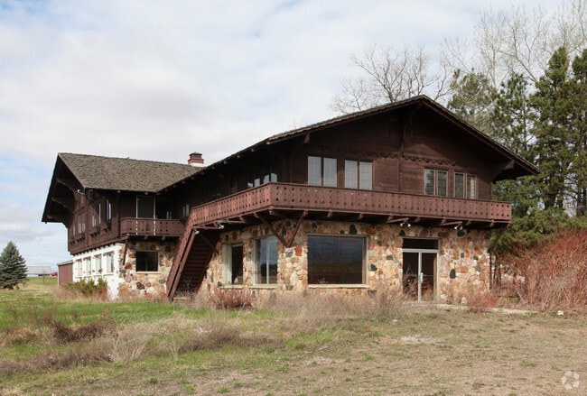


Property Detail
2701 Alpine Rd
14-1291
LOT 2 CSM V 6 P 22 #1099 LYING IN NE1/4 OF NE1/4 SEC 11-27-10 ANNEX FROM TWN OF UNION FOR 2010
Commercialnec
Eau Claire
TR1A
Wisconsin
B and X Area of moderate flood hazard, usually the area between the limits of the 100-year and 500-year floods.
2
2025
4.62 AC
2025
Eau Claire/Menomonie
001500
Other Market Areas
8,460 SF
Eau Claire, WI
NEARBY LISTINGS FOR SALE OR LEASE
-
-
View all Eau Claire listings for sale on LoopNet.com
DEMOGRAPHICS near 2701 Alpine Rd
1 mile
3 mile
5 mile
2025 Total Population
1,684
23,209
63,761
2030 Population
1,748
23,943
65,376
Pop Growth 2025-2030
+ 3.80%
+ 3.16%
+ 2.53%
Average Age
40
38
37
2025 Total Households
675
9,841
26,007
HH Growth 2025-2030
+ 3.85%
+ 3.24%
+ 2.69%
Median Household Inc
$80,303
$69,549
$69,902
Avg Household Size
2.40
2.30
2.20
2025 Avg HH Vehicles
2.00
2.00
2.00
Median Home Value
$276,530
$244,768
$246,537
Median Year Built
1998
1977
1973
Nearby Places
Map Layers
Map Styles
 Street
 Aerial
Layers
 Traffic
 Biking
Places
Listings with unknown addresses are not visible on the map
- Restaurants
- Banks
- Shops
- Fitness
- Groceries
SALE & LEASE HISTORY
LISTING DATE
SALE/LEASE

Jun 24, 2021
For Sale
Nearby Properties
Address
Land Use
TOTAL SIZE
Lot Size
Zoning
Address
Land Use
TOTAL SIZE
Lot Size
Zoning
119.93 AC
Address
Land Use
TOTAL SIZE
Lot Size
Zoning
203,723 SF
Address
Land Use
TOTAL SIZE
Lot Size
Zoning
33.32 AC
I1
Address
Land Use
TOTAL SIZE
Lot Size
Zoning
0.78 AC
Address
Land Use
TOTAL SIZE
Lot Size
Zoning
61.27 AC
C2
Address
Land Use
TOTAL SIZE
Lot Size
Zoning
40.76 AC
I1P
Address
Land Use
TOTAL SIZE
Lot Size
Zoning
21.83 AC
I1
Address
Land Use
TOTAL SIZE
Lot Size
Zoning
66.12 AC
I1
Address
Land Use
TOTAL SIZE
Lot Size
Zoning
1.05 AC
P
Address
Land Use
TOTAL SIZE
Lot Size
Zoning
105,434 SF
1.55 AC
CBD
Address
Land Use
TOTAL SIZE
Lot Size
Zoning
65,378 SF
1.83 AC
Address
Land Use
TOTAL SIZE
Lot Size
Zoning
68,024 SF
0.80 AC
CBD
Address
Land Use
TOTAL SIZE
Lot Size
Zoning
169,740 SF
19.59 AC
C3P
Address
Land Use
TOTAL SIZE
Lot Size
Zoning
163,428 SF
30.30 AC
I1P
Address
Land Use
TOTAL SIZE
Lot Size
Zoning
Address
Land Use
TOTAL SIZE
Lot Size
Zoning
Address
Land Use
TOTAL SIZE
Lot Size
Zoning
66,497 SF
0.81 AC
CBDP
Address
Land Use
TOTAL SIZE
Lot Size
Zoning
36.59 AC
I1
Address
Land Use
TOTAL SIZE
Lot Size
Zoning
207,960 SF
9.22 AC
I1P
Address
Land Use
TOTAL SIZE
Lot Size
Zoning
9.70 AC
C3
Address
Land Use
TOTAL SIZE
Lot Size
Zoning
38,808 SF
11.65 AC
I1P
Address
Land Use
TOTAL SIZE
Lot Size
Zoning
103,890 SF
6.30 AC
R4P
Address
Land Use
TOTAL SIZE
Lot Size
Zoning
10.68 AC
I1P
Address
Land Use
TOTAL SIZE
Lot Size
Zoning
73,414 SF
2.46 AC
C3P
Address
Land Use
TOTAL SIZE
Lot Size
Zoning
14.28 AC
I1P
Address
Land Use
TOTAL SIZE
Lot Size
Zoning
38.99 AC
I1
Address
Land Use
TOTAL SIZE
Lot Size
Zoning
25.27 AC
I2
Address
Land Use
TOTAL SIZE
Lot Size
Zoning
69,320 SF
5.98 AC
Address
Land Use
TOTAL SIZE
Lot Size
Zoning
50,980 SF
1.99 AC
R3P
Address
Land Use
TOTAL SIZE
Lot Size
Zoning
5.24 AC
The World's #1 Commercial Real Estate Marketplace
Connect with us
© 2026 CoStar Group
The information above has been obtained from sources believed reliable. While we do not doubt its accuracy we have not verified it and make no guarantee, warranty or representation about it. It is your responsibility to independently confirm its accuracy and completeness. Any projections, opinions, assumptions, or estimates used are for example only and do not represent the current or future performance of the property. The value of this transaction to you depends on tax and other factors which should be evaluated by your tax, financial, and legal advisors. You and your advisors should conduct a careful, independent investigation of the property to determine to your satisfaction the suitability of the property for your needs.