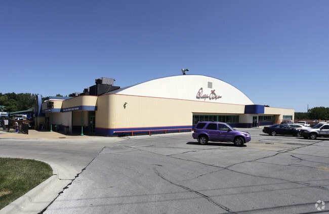
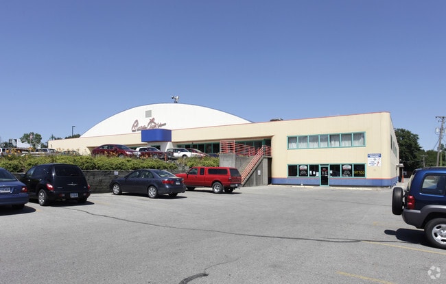
Property Record
2701 Douglas Ave, Des Moines, IA 50310

Property Detail
2701 Douglas Ave
080-01785008000
PARCEL 2024-20 BK 19914 PG 977 LOTS 4 & 5 EUCLID HEIGHTS
Miscellaneous
POLK
C-2
Iowa
B and X Area of moderate flood hazard, usually the area between the limits of the 100-year and 500-year floods.
4,5
2024
2.44 AC
2025
Northwest
000702
Des Moines
31,292 SF
Des Moines-West Des Moines, IA
NEARBY LISTINGS FOR SALE OR LEASE
DEMOGRAPHICS near 2701 Douglas Ave
1 mile
3 mile
5 mile
2025 Total Population
10,796
96,848
208,138
2030 Population
11,175
101,201
216,984
Pop Growth 2025-2030
+ 3.51%
+ 4.49%
+ 4.25%
Average Age
38
37
38
2025 Total Households
4,345
39,749
88,210
HH Growth 2025-2030
+ 3.66%
+ 4.71%
+ 4.56%
Median Household Inc
$63,146
$61,331
$66,270
Avg Household Size
2.40
2.30
2.20
2025 Avg HH Vehicles
2.00
2.00
2.00
Median Home Value
$210,469
$205,856
$235,248
Median Year Built
1957
1953
1964
Nearby Places
Map Layers
Map Styles
 Street
 Aerial
Transit
 Traffic
 Biking
Places
Listings with unknown addresses are not visible on the map
- Restaurants
- Banks
- Shops
- Fitness
- Groceries
PUBLIC TRANSPORTATION
AIRPORT
Des Moines International
Drive
Walk
Distance
Des Moines International
18 min
7.5 mi
Freight Ports
Port Milwaukee
Drive
Walk
Distance
Port Milwaukee
416 min
373.3 mi
Nearby Properties
Address
Land Use
TOTAL SIZE
Lot Size
Zoning
Address
Land Use
TOTAL SIZE
Lot Size
Zoning
936,742 SF
6.85 AC
C-0
Address
Land Use
TOTAL SIZE
Lot Size
Zoning
2,157,357 SF
23.95 AC
PUD
Address
Land Use
TOTAL SIZE
Lot Size
Zoning
428,582 SF
6.87 AC
C-0
Address
Land Use
TOTAL SIZE
Lot Size
Zoning
481,030 SF
31.92 AC
PUD
Address
Land Use
TOTAL SIZE
Lot Size
Zoning
339,258 SF
9.50 AC
R3
Address
Land Use
TOTAL SIZE
Lot Size
Zoning
529,814 SF
3.11 AC
C-3
Address
Land Use
TOTAL SIZE
Lot Size
Zoning
274,736 SF
10.27 AC
R-3
Address
Land Use
TOTAL SIZE
Lot Size
Zoning
162,578 SF
6.37 AC
Address
Land Use
TOTAL SIZE
Lot Size
Zoning
254,071 SF
9.17 AC
R3
Address
Land Use
TOTAL SIZE
Lot Size
Zoning
122,364 SF
0.96 AC
C-0
Address
Land Use
TOTAL SIZE
Lot Size
Zoning
179,663 SF
2.27 AC
PUD
Address
Land Use
TOTAL SIZE
Lot Size
Zoning
244,212 SF
2.20 AC
NPC
Address
Land Use
TOTAL SIZE
Lot Size
Zoning
289,966 SF
8.57 AC
R-3
Address
Land Use
TOTAL SIZE
Lot Size
Zoning
82,525 SF
0.97 AC
Address
Land Use
TOTAL SIZE
Lot Size
Zoning
96,450 SF
9.90 AC
R3
Address
Land Use
TOTAL SIZE
Lot Size
Zoning
307,734 SF
23.59 AC
R-3
Address
Land Use
TOTAL SIZE
Lot Size
Zoning
1,838,971 SF
76.24 AC
HI
Address
Land Use
TOTAL SIZE
Lot Size
Zoning
103,780 SF
3.39 AC
C-3A
Address
Land Use
TOTAL SIZE
Lot Size
Zoning
82,202 SF
9.48 AC
PUD
Address
Land Use
TOTAL SIZE
Lot Size
Zoning
184,320 SF
9.68 AC
Address
Land Use
TOTAL SIZE
Lot Size
Zoning
386,236 SF
9.62 AC
C-4
Address
Land Use
TOTAL SIZE
Lot Size
Zoning
117,272 SF
3.46 AC
R1-60
Address
Land Use
TOTAL SIZE
Lot Size
Zoning
108,711 SF
0.57 AC
C-0
Address
Land Use
TOTAL SIZE
Lot Size
Zoning
374,551 SF
9.37 AC
R-3
Address
Land Use
TOTAL SIZE
Lot Size
Zoning
162,240 SF
9.19 AC
Address
Land Use
TOTAL SIZE
Lot Size
Zoning
188,453 SF
14.20 AC
R-3
Address
Land Use
TOTAL SIZE
Lot Size
Zoning
110,637 SF
11.05 AC
R-3
Address
Land Use
TOTAL SIZE
Lot Size
Zoning
343,525 SF
1.42 AC
C-0
Address
Land Use
TOTAL SIZE
Lot Size
Zoning
223,876 SF
15.01 AC
Address
Land Use
TOTAL SIZE
Lot Size
Zoning
107,395 SF
6.78 AC
R-3
The World's #1 Commercial Real Estate Marketplace
Connect with us
© 2026 CoStar Group
The information above has been obtained from sources believed reliable. While we do not doubt its accuracy we have not verified it and make no guarantee, warranty or representation about it. It is your responsibility to independently confirm its accuracy and completeness. Any projections, opinions, assumptions, or estimates used are for example only and do not represent the current or future performance of the property. The value of this transaction to you depends on tax and other factors which should be evaluated by your tax, financial, and legal advisors. You and your advisors should conduct a careful, independent investigation of the property to determine to your satisfaction the suitability of the property for your needs.