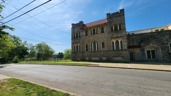
Property Record
2701 E 43Rd St, Kansas City, MO 64130


Property Detail
2701 E 43Rd St
Kansas City, MO-KS
SHARON PLACE PT OF LOT 3 DAF: BEG NW COR OF LOT 3 TH S ALG W LI OF LOT 3 183.25 TO SW COR OF LOT 3 TH S 89 DEG E ALG S LI OF LOT 3 138.88 TH N 41.50 TH S 89 DEG E 138.87 TO A P
31-420-07-17-01-0-00-000
JACKSON
Religious
Missouri
B and X Area of moderate flood hazard, usually the area between the limits of the 100-year and 500-year floods.
3
0
1.04 AC
2025
Kansas City MO
006100
Kansas City
19,804 SF
NEARBY LISTINGS FOR SALE OR LEASE
DEMOGRAPHICS near 2701 E 43Rd St
1 mile
3 mile
5 mile
2025 Total Population
15,493
119,694
266,710
2030 Population
16,300
124,234
275,030
Pop Growth 2025-2030
+ 5.21%
+ 3.79%
+ 3.12%
Average Age
39
38
38
2025 Total Households
6,476
56,269
119,519
HH Growth 2025-2030
+ 5.23%
+ 3.78%
+ 3.19%
Median Household Inc
$42,792
$55,442
$58,742
Avg Household Size
2.30
2.00
2.10
2025 Avg HH Vehicles
1.00
1.00
1.00
Median Home Value
$79,454
$209,841
$220,258
Median Year Built
1948
1951
1953
Nearby Places
Map Layers
Map Styles
 Street
 Aerial
Transit
 Traffic
 Biking
Places
Listings with unknown addresses are not visible on the map
- Restaurants
- Banks
- Shops
- Fitness
- Groceries
PUBLIC TRANSPORTATION
COMMUTER RAIL
Drive
Walk
Distance
10 min
4.7 mi
Drive
Walk
Distance
19 min
9.7 mi
AIRPORT
Kansas City International
Drive
Walk
Distance
Kansas City International
35 min
24.9 mi
Nearby Properties
Address
Land Use
TOTAL SIZE
Lot Size
Zoning
Address
Land Use
TOTAL SIZE
Lot Size
Zoning
761,113 SF
18.37 AC
KC3
Address
Land Use
TOTAL SIZE
Lot Size
Zoning
711,196 SF
15.58 AC
Address
Land Use
TOTAL SIZE
Lot Size
Zoning
105,247 SF
0.72 AC
Address
Land Use
TOTAL SIZE
Lot Size
Zoning
543,241 SF
8.39 AC
Address
Land Use
TOTAL SIZE
Lot Size
Zoning
257,647 SF
3.63 AC
Address
Land Use
TOTAL SIZE
Lot Size
Zoning
626,244 SF
16.41 AC
Address
Land Use
TOTAL SIZE
Lot Size
Zoning
44,491 SF
1.96 AC
C3A2
Address
Land Use
TOTAL SIZE
Lot Size
Zoning
803,812 SF
5.85 AC
Address
Land Use
TOTAL SIZE
Lot Size
Zoning
129,265 SF
1.17 AC
Address
Land Use
TOTAL SIZE
Lot Size
Zoning
274,622 SF
1.35 AC
Address
Land Use
TOTAL SIZE
Lot Size
Zoning
109,563 SF
0.98 AC
Address
Land Use
TOTAL SIZE
Lot Size
Zoning
149,157 SF
0.02 AC
URD
Address
Land Use
TOTAL SIZE
Lot Size
Zoning
251,409 SF
3.39 AC
Address
Land Use
TOTAL SIZE
Lot Size
Zoning
379,472 SF
Address
Land Use
TOTAL SIZE
Lot Size
Zoning
349,977 SF
2.21 AC
Address
Land Use
TOTAL SIZE
Lot Size
Zoning
369,624 SF
7.50 AC
Address
Land Use
TOTAL SIZE
Lot Size
Zoning
480,594 SF
44 SF
Address
Land Use
TOTAL SIZE
Lot Size
Zoning
64,964 SF
0.85 AC
Address
Land Use
TOTAL SIZE
Lot Size
Zoning
193,643 SF
20.63 AC
Address
Land Use
TOTAL SIZE
Lot Size
Zoning
416,673 SF
8.74 AC
Address
Land Use
TOTAL SIZE
Lot Size
Zoning
165,265 SF
1.13 AC
Address
Land Use
TOTAL SIZE
Lot Size
Zoning
70,449 SF
0.66 AC
Address
Land Use
TOTAL SIZE
Lot Size
Zoning
174,983 SF
10.43 AC
Address
Land Use
TOTAL SIZE
Lot Size
Zoning
48,224 SF
1.09 AC
Address
Land Use
TOTAL SIZE
Lot Size
Zoning
392,653 SF
19.69 AC
Address
Land Use
TOTAL SIZE
Lot Size
Zoning
153,946 SF
5.91 AC
Address
Land Use
TOTAL SIZE
Lot Size
Zoning
50,684 SF
0.07 AC
Address
Land Use
TOTAL SIZE
Lot Size
Zoning
785,016 SF
23.73 AC
Address
Land Use
TOTAL SIZE
Lot Size
Zoning
136,963 SF
2.05 AC
Address
Land Use
TOTAL SIZE
Lot Size
Zoning
213,914 SF
3.60 AC
The World's #1 Commercial Real Estate Marketplace
Connect with us
© 2026 CoStar Group
The information above has been obtained from sources believed reliable. While we do not doubt its accuracy we have not verified it and make no guarantee, warranty or representation about it. It is your responsibility to independently confirm its accuracy and completeness. Any projections, opinions, assumptions, or estimates used are for example only and do not represent the current or future performance of the property. The value of this transaction to you depends on tax and other factors which should be evaluated by your tax, financial, and legal advisors. You and your advisors should conduct a careful, independent investigation of the property to determine to your satisfaction the suitability of the property for your needs.