Property Record
2701 Freeport Rd, Pittsburgh, PA 15238


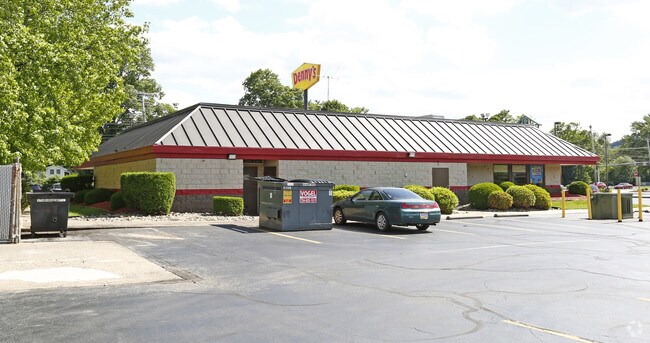
Property Detail
2701 Freeport Rd
Pittsburgh, PA
HARMAR LANDINGS PLAN NO 2F PARCEL Q = 500 FRONTING W/ 8 BEARINGS TOTAL
0441-D-00225-0000-00
Allegheny
Restaurantdrivein
Pennsylvania
B and X Area of moderate flood hazard, usually the area between the limits of the 100-year and 500-year floods.
225
2024
2.98 AC
2025
Northeast Pittsburgh
419000
Pittsburgh
NEARBY LISTINGS FOR SALE OR LEASE
DEMOGRAPHICS near 2701 Freeport Rd
1 mile
3 mile
5 mile
2025 Total Population
1,360
30,346
85,272
2030 Population
1,354
29,861
84,324
Pop Growth 2025-2030
(0.44%)
(1.60%)
(1.11%)
Average Age
49
46
45
2025 Total Households
548
13,746
37,759
HH Growth 2025-2030
(0.91%)
(1.64%)
(1.15%)
Median Household Inc
$89,749
$83,077
$76,453
Avg Household Size
2.10
2.10
2.20
2025 Avg HH Vehicles
2.00
2.00
2.00
Median Home Value
$424,683
$247,142
$206,076
Median Year Built
1963
1960
1959
Nearby Places
Map Layers
Map Styles
 Street
 Aerial
Transit
 Traffic
 Biking
Places
Listings with unknown addresses are not visible on the map
- Restaurants
- Banks
- Shops
- Fitness
- Groceries
PUBLIC TRANSPORTATION
AIRPORT
Pittsburgh International
Drive
Walk
Distance
Pittsburgh International
47 min
30.8 mi
Arnold Palmer Regional
Drive
Walk
Distance
Arnold Palmer Regional
56 min
38.2 mi
Nearby Properties
Address
Land Use
TOTAL SIZE
Lot Size
Zoning
Address
Land Use
TOTAL SIZE
Lot Size
Zoning
41.36 AC
Address
Land Use
TOTAL SIZE
Lot Size
Zoning
4,242 SF
115.01 AC
Address
Land Use
TOTAL SIZE
Lot Size
Zoning
36.44 AC
Address
Land Use
TOTAL SIZE
Lot Size
Zoning
11.28 AC
Address
Land Use
TOTAL SIZE
Lot Size
Zoning
23.45 AC
Address
Land Use
TOTAL SIZE
Lot Size
Zoning
42.71 AC
Address
Land Use
TOTAL SIZE
Lot Size
Zoning
528.43 AC
Address
Land Use
TOTAL SIZE
Lot Size
Zoning
119.91 AC
Address
Land Use
TOTAL SIZE
Lot Size
Zoning
6.35 AC
Address
Land Use
TOTAL SIZE
Lot Size
Zoning
4,836 SF
30.63 AC
Address
Land Use
TOTAL SIZE
Lot Size
Zoning
5.44 AC
Address
Land Use
TOTAL SIZE
Lot Size
Zoning
15.37 AC
Address
Land Use
TOTAL SIZE
Lot Size
Zoning
48.10 AC
Address
Land Use
TOTAL SIZE
Lot Size
Zoning
54.90 AC
Address
Land Use
TOTAL SIZE
Lot Size
Zoning
13.68 AC
Address
Land Use
TOTAL SIZE
Lot Size
Zoning
84.40 AC
Address
Land Use
TOTAL SIZE
Lot Size
Zoning
37.84 AC
Address
Land Use
TOTAL SIZE
Lot Size
Zoning
Address
Land Use
TOTAL SIZE
Lot Size
Zoning
1,422 SF
162.05 AC
Address
Land Use
TOTAL SIZE
Lot Size
Zoning
72.14 AC
Address
Land Use
TOTAL SIZE
Lot Size
Zoning
10.20 AC
Address
Land Use
TOTAL SIZE
Lot Size
Zoning
25.97 AC
Address
Land Use
TOTAL SIZE
Lot Size
Zoning
Address
Land Use
TOTAL SIZE
Lot Size
Zoning
1.21 AC
Address
Land Use
TOTAL SIZE
Lot Size
Zoning
23.95 AC
Address
Land Use
TOTAL SIZE
Lot Size
Zoning
Address
Land Use
TOTAL SIZE
Lot Size
Zoning
889 SF
31.93 AC
Address
Land Use
TOTAL SIZE
Lot Size
Zoning
Address
Land Use
TOTAL SIZE
Lot Size
Zoning
21.20 AC
Address
Land Use
TOTAL SIZE
Lot Size
Zoning
12.10 AC
The World's #1 Commercial Real Estate Marketplace
Connect with us
© 2026 CoStar Group
The information above has been obtained from sources believed reliable. While we do not doubt its accuracy we have not verified it and make no guarantee, warranty or representation about it. It is your responsibility to independently confirm its accuracy and completeness. Any projections, opinions, assumptions, or estimates used are for example only and do not represent the current or future performance of the property. The value of this transaction to you depends on tax and other factors which should be evaluated by your tax, financial, and legal advisors. You and your advisors should conduct a careful, independent investigation of the property to determine to your satisfaction the suitability of the property for your needs.