Property Record
2701 Johnson Controls Dr, Kernersville, NC 27284
NEARBY LISTINGS FOR SALE OR LEASE
Property Detail
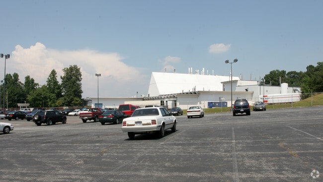
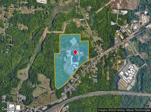
2701 Johnson Controls Dr
Winston-Salem, NC
Johnson Controls
6856-74-1395
JOHNSON CONTROLS LO:201 BL:3262 BU:1
Heavyindustrial
Forsyth
X
North Carolina
3710685600J
201
2023
74.78 AC
2025
NE Forsyth County
003201
Greensboro/Winston-Salem
66,980 SF
DEMOGRAPHICS near 2701 Johnson Controls Dr
1 Mile
3 Mile
5 Mile
2024 Total Population
1,717
28,347
103,087
2029 Population
1,778
29,474
107,667
Pop Growth 2024-2029
+ 3.55%
+ 3.98%
+ 4.44%
Average Age
41
40
39
2024 Total Households
704
10,955
40,028
HH Growth 2024-2029
+ 3.55%
+ 3.98%
+ 4.47%
Median Household Inc
$56,363
$64,284
$51,596
Avg Household Size
2.40
2.50
2.40
2024 Avg HH Vehicles
2.00
2.00
2.00
Median Home Value
$238,271
$196,204
$185,342
Median Year Built
1984
1984
1979
Nearby Places
Map Layers
Map Styles
 Street
 Aerial
- Restaurants
- Banks
- Shops
- Fitness
- Groceries
PUBLIC TRANSPORTATION
AIRPORT
Piedmont Triad International
DRIVE
WALK
Distance
Piedmont Triad International
30 min
16.9 mi
Freight Ports
Virginia Port Authority - Richmond
DRIVE
WALK
Distance
Virginia Port Authority - Richmond
256 min
220.5 mi
Nearby Properties
Address
Land Use
TOTAL SIZE
Lot Size
Zoning
Address
Land Use
TOTAL SIZE
Lot Size
Zoning
188,273 SF
54.55 AC
IP
Address
Land Use
TOTAL SIZE
Lot Size
Zoning
1,182.87 AC
IP
Address
Land Use
TOTAL SIZE
Lot Size
Zoning
78,274 SF
27.95 AC
RM8-S
Address
Land Use
TOTAL SIZE
Lot Size
Zoning
98,617 SF
37.44 AC
RS20
Address
Land Use
TOTAL SIZE
Lot Size
Zoning
85,000 SF
48.02 AC
IP
Address
Land Use
TOTAL SIZE
Lot Size
Zoning
102,809 SF
16.74 AC
BI
Address
Land Use
TOTAL SIZE
Lot Size
Zoning
77,891 SF
20.91 AC
RS9
Address
Land Use
TOTAL SIZE
Lot Size
Zoning
66,245 SF
12.60 AC
RM12
Address
Land Use
TOTAL SIZE
Lot Size
Zoning
157,878 SF
11 AC
GI
Address
Land Use
TOTAL SIZE
Lot Size
Zoning
225,955 SF
64.68 AC
LI
Address
Land Use
TOTAL SIZE
Lot Size
Zoning
52,480 SF
30.51 AC
BI
Address
Land Use
TOTAL SIZE
Lot Size
Zoning
52,792 SF
25.21 AC
BI
Address
Land Use
TOTAL SIZE
Lot Size
Zoning
100 SF
12.10 AC
RM8-S
Address
Land Use
TOTAL SIZE
Lot Size
Zoning
15,300 SF
292.13 AC
IP,RM18,RS
Address
Land Use
TOTAL SIZE
Lot Size
Zoning
69,708 SF
16.10 AC
RM12
Address
Land Use
TOTAL SIZE
Lot Size
Zoning
73,868 SF
7.35 AC
IP
Address
Land Use
TOTAL SIZE
Lot Size
Zoning
11,500 SF
139.75 AC
GI,RS9
Address
Land Use
TOTAL SIZE
Lot Size
Zoning
73,732 SF
8.05 AC
IP
Address
Land Use
TOTAL SIZE
Lot Size
Zoning
86,632 SF
6.99 AC
BI
Address
Land Use
TOTAL SIZE
Lot Size
Zoning
63,814 SF
18.93 AC
IP
Address
Land Use
TOTAL SIZE
Lot Size
Zoning
221,576 SF
39.69 AC
IP,RM12
Address
Land Use
TOTAL SIZE
Lot Size
Zoning
34,104 SF
7.82 AC
RM12-S
Address
Land Use
TOTAL SIZE
Lot Size
Zoning
34,496 SF
6.26 AC
RM18
Address
Land Use
TOTAL SIZE
Lot Size
Zoning
39,445 SF
3.49 AC
IP
Address
Land Use
TOTAL SIZE
Lot Size
Zoning
42,484 SF
10.84 AC
IP-S
Address
Land Use
TOTAL SIZE
Lot Size
Zoning
68,106 SF
18.45 AC
IP
Address
Land Use
TOTAL SIZE
Lot Size
Zoning
61,475 SF
6.93 AC
HB
Address
Land Use
TOTAL SIZE
Lot Size
Zoning
185,141 SF
19.34 AC
LI
Address
Land Use
TOTAL SIZE
Lot Size
Zoning
6,436 SF
23.85 AC
RM8-S
The World's #1 Commercial Real Estate Marketplace
Connect with us
© 2025 CoStar Group
The information above has been obtained from sources believed reliable. While we do not doubt its accuracy we have not verified it and make no guarantee, warranty or representation about it. It is your responsibility to independently confirm its accuracy and completeness. Any projections, opinions, assumptions, or estimates used are for example only and do not represent the current or future performance of the property. The value of this transaction to you depends on tax and other factors which should be evaluated by your tax, financial, and legal advisors. You and your advisors should conduct a careful, independent investigation of the property to determine to your satisfaction the suitability of the property for your needs.