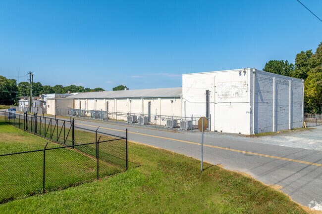
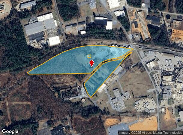
Property Record
2701 Simpson St, Monroe, NC 28112

NEARBY LISTINGS FOR SALE OR LEASE
Property Detail
2701 Simpson St
09-118-004-70
6761-573 09118004 70 = 30.040/30.540 AC
Manufacturinglight
Union
X
North Carolina
3710545500J
30.04 AC
2025
Union County
2025
Charlotte
020601
Charlotte-Concord-Gastonia, NC-SC
88,895 SF
DEMOGRAPHICS near 2701 Simpson St
1 Mile
3 Mile
5 Mile
2024 Total Population
2,044
15,587
39,199
2029 Population
2,337
17,424
43,864
Pop Growth 2024-2029
+ 14.33%
+ 11.79%
+ 11.90%
Average Age
35
38
38
2024 Total Households
633
5,170
13,217
HH Growth 2024-2029
+ 14.69%
+ 12.05%
+ 12.39%
Median Household Inc
$48,653
$48,916
$57,128
Avg Household Size
3.00
2.80
2.70
2024 Avg HH Vehicles
2.00
2.00
2.00
Median Home Value
$191,249
$251,805
$245,384
Median Year Built
1990
1981
1986
Nearby Places
Map Layers
Map Styles
 Street
 Aerial
- Restaurants
- Banks
- Shops
- Fitness
- Groceries
PUBLIC TRANSPORTATION
AIRPORT
Charlotte/Douglas International
DRIVE
WALK
Distance
Charlotte/Douglas International
54 min
35.2 mi
Freight Ports
North Charleston Terminal
DRIVE
WALK
Distance
North Charleston Terminal
222 min
184.5 mi
SALE & LEASE HISTORY
LISTING DATE
SALE/LEASE

Jun 30, 2025
For Sale
Jun 09, 2023
For Sale
Aug 20, 2018
For Sale
Nearby Properties
Address
Land Use
TOTAL SIZE
Lot Size
Zoning
Address
Land Use
TOTAL SIZE
Lot Size
Zoning
78.48 AC
Address
Land Use
TOTAL SIZE
Lot Size
Zoning
68,870 SF
33.25 AC
HC WINGATE
Address
Land Use
TOTAL SIZE
Lot Size
Zoning
134,187 SF
32.44 AC
R-10 MONRO
Address
Land Use
TOTAL SIZE
Lot Size
Zoning
99,235 SF
1.92 AC
CBD MONROE
Address
Land Use
TOTAL SIZE
Lot Size
Zoning
82.26 AC
G-I MONROE
Address
Land Use
TOTAL SIZE
Lot Size
Zoning
68,258 SF
3.39 AC
R-20 WINGA
Address
Land Use
TOTAL SIZE
Lot Size
Zoning
7,104 SF
11.99 AC
R-MF MONRO
Address
Land Use
TOTAL SIZE
Lot Size
Zoning
4,608 SF
5.08 AC
OT MONROE
Address
Land Use
TOTAL SIZE
Lot Size
Zoning
104,837 SF
29.15 AC
CD MONROE
Address
Land Use
TOTAL SIZE
Lot Size
Zoning
3,276 SF
6.20 AC
R-MF MONRO
Address
Land Use
TOTAL SIZE
Lot Size
Zoning
121,790 SF
52.36 AC
G-I MONROE
Address
Land Use
TOTAL SIZE
Lot Size
Zoning
79,493 SF
32.65 AC
RA-20 UNIO
Address
Land Use
TOTAL SIZE
Lot Size
Zoning
41,820 SF
6.23 AC
G-I MONROE
Address
Land Use
TOTAL SIZE
Lot Size
Zoning
2,873 SF
55.59 AC
G-I MONROE
Address
Land Use
TOTAL SIZE
Lot Size
Zoning
65,122 SF
5.26 AC
R-10 MONRO
Address
Land Use
TOTAL SIZE
Lot Size
Zoning
32,872 SF
9.35 AC
Address
Land Use
TOTAL SIZE
Lot Size
Zoning
28,468 SF
3.51 AC
B-1 WINGAT
Address
Land Use
TOTAL SIZE
Lot Size
Zoning
32,815 SF
8.28 AC
R-20 MONRO
Address
Land Use
TOTAL SIZE
Lot Size
Zoning
72,444 SF
5.06 AC
GB MONROE
Address
Land Use
TOTAL SIZE
Lot Size
Zoning
214,256 SF
16.68 AC
G-I MONROE
Address
Land Use
TOTAL SIZE
Lot Size
Zoning
2,712 SF
7.11 AC
R-MH MONRO
Address
Land Use
TOTAL SIZE
Lot Size
Zoning
33,699 SF
2.55 AC
OT MONROE
Address
Land Use
TOTAL SIZE
Lot Size
Zoning
80,000 SF
10.19 AC
G-I MONROE
Address
Land Use
TOTAL SIZE
Lot Size
Zoning
18,200 SF
0.76 AC
CBD MONROE
Address
Land Use
TOTAL SIZE
Lot Size
Zoning
20,700 SF
4.76 AC
CBD MONROE
Address
Land Use
TOTAL SIZE
Lot Size
Zoning
13,016 SF
15.38 AC
GB MONROE
Address
Land Use
TOTAL SIZE
Lot Size
Zoning
61,165 SF
6.59 AC
GB MONROE
Address
Land Use
TOTAL SIZE
Lot Size
Zoning
33,946 SF
2.48 AC
CD MONROE
Address
Land Use
TOTAL SIZE
Lot Size
Zoning
97,344 SF
31.11 AC
R-10 MONRO
Address
Land Use
TOTAL SIZE
Lot Size
Zoning
21,576 SF
1.37 AC
GB MONROE
The World's #1 Commercial Real Estate Marketplace
Connect with us
© 2025 CoStar Group
The information above has been obtained from sources believed reliable. While we do not doubt its accuracy we have not verified it and make no guarantee, warranty or representation about it. It is your responsibility to independently confirm its accuracy and completeness. Any projections, opinions, assumptions, or estimates used are for example only and do not represent the current or future performance of the property. The value of this transaction to you depends on tax and other factors which should be evaluated by your tax, financial, and legal advisors. You and your advisors should conduct a careful, independent investigation of the property to determine to your satisfaction the suitability of the property for your needs.