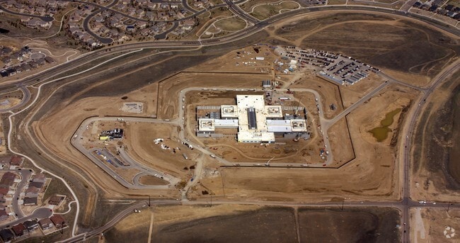
Property Record
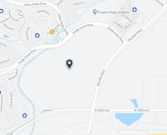
2701 W 160Th Ave, Broomfield, CO 80023

Property Detail
2701 W 160Th Ave
1573-05-4-08-001
SUBD: NORTH PARK FILING NO 4 LOT: 1 BLOCK: 1
Miscellaneous
BROOMFIELD
PUD
Colorado
B and X Area of moderate flood hazard, usually the area between the limits of the 100-year and 500-year floods.
1
2025
106.32 AC
2026
Broomfield County
031403
Denver
190,387 SF
Denver-Aurora-Centennial, CO
NEARBY LISTINGS FOR SALE OR LEASE
-
-
-
5280 Logistics Park - 15210 Washington St
Thornton, CO 80023
Rent Upon Request
121,640 SF
Industrial
-
-
-
-
-
View all Broomfield listings for sale on LoopNet.com
DEMOGRAPHICS near 2701 W 160Th Ave
1 mile
3 mile
5 mile
2025 Total Population
7,910
36,861
144,000
2030 Population
8,526
39,190
150,336
Pop Growth 2025-2030
+ 7.79%
+ 6.32%
+ 4.40%
Average Age
36
40
39
2025 Total Households
2,530
13,470
51,659
HH Growth 2025-2030
+ 8.22%
+ 6.47%
+ 4.41%
Median Household Inc
$189,476
$153,470
$138,228
Avg Household Size
3.10
2.70
2.70
2025 Avg HH Vehicles
2.00
2.00
2.00
Median Home Value
$860,266
$789,165
$736,442
Median Year Built
2010
2009
2003
Nearby Places
Map Layers
Map Styles
 Street
 Aerial
Layers
 Traffic
 Biking
Places
Listings with unknown addresses are not visible on the map
- Restaurants
- Banks
- Shops
- Fitness
- Groceries
PUBLIC TRANSPORTATION
COMMUTER RAIL
Drive
Walk
Distance
15 min
7.8 mi
Drive
Walk
Distance
17 min
10.0 mi
AIRPORT
Denver International
Drive
Walk
Distance
Denver International
32 min
26.9 mi
Nearby Properties
Address
Land Use
TOTAL SIZE
Lot Size
Zoning
Address
Land Use
TOTAL SIZE
Lot Size
Zoning
385,623 SF
32.77 AC
Address
Land Use
TOTAL SIZE
Lot Size
Zoning
355,866 SF
16.17 AC
Address
Land Use
TOTAL SIZE
Lot Size
Zoning
538,595 SF
87.92 AC
Address
Land Use
TOTAL SIZE
Lot Size
Zoning
712,276 SF
72.16 AC
Address
Land Use
TOTAL SIZE
Lot Size
Zoning
177,730 SF
17.82 AC
PUD
Address
Land Use
TOTAL SIZE
Lot Size
Zoning
869,000 SF
61.97 AC
Address
Land Use
TOTAL SIZE
Lot Size
Zoning
312,952 SF
181.60 AC
OLPF
Address
Land Use
TOTAL SIZE
Lot Size
Zoning
202,491 SF
52.56 AC
PUD
Address
Land Use
TOTAL SIZE
Lot Size
Zoning
103,416 SF
45.52 AC
PUD
Address
Land Use
TOTAL SIZE
Lot Size
Zoning
333,686 SF
19.68 AC
PUD
Address
Land Use
TOTAL SIZE
Lot Size
Zoning
74,610 SF
1.56 AC
Address
Land Use
TOTAL SIZE
Lot Size
Zoning
116.21 AC
A
Address
Land Use
TOTAL SIZE
Lot Size
Zoning
136,036 SF
12.87 AC
PUD
Address
Land Use
TOTAL SIZE
Lot Size
Zoning
253,459 SF
34.63 AC
Address
Land Use
TOTAL SIZE
Lot Size
Zoning
284,997 SF
13.55 AC
PUD
Address
Land Use
TOTAL SIZE
Lot Size
Zoning
176,000 SF
12.03 AC
Address
Land Use
TOTAL SIZE
Lot Size
Zoning
238,854 SF
12.75 AC
PUD
Address
Land Use
TOTAL SIZE
Lot Size
Zoning
18,900 SF
60.88 AC
PUD
Address
Land Use
TOTAL SIZE
Lot Size
Zoning
132.98 AC
Address
Land Use
TOTAL SIZE
Lot Size
Zoning
297,895 SF
6.77 AC
Address
Land Use
TOTAL SIZE
Lot Size
Zoning
146,300 SF
9 AC
Address
Land Use
TOTAL SIZE
Lot Size
Zoning
164,372 SF
11.58 AC
PUD
Address
Land Use
TOTAL SIZE
Lot Size
Zoning
386,513 SF
4.89 AC
Address
Land Use
TOTAL SIZE
Lot Size
Zoning
268,040 SF
17.59 AC
Address
Land Use
TOTAL SIZE
Lot Size
Zoning
281,315 SF
7.84 AC
PUD
Address
Land Use
TOTAL SIZE
Lot Size
Zoning
152,841 SF
7.74 AC
PUD
Address
Land Use
TOTAL SIZE
Lot Size
Zoning
128,656 SF
6.27 AC
Address
Land Use
TOTAL SIZE
Lot Size
Zoning
112,594 SF
12.35 AC
Address
Land Use
TOTAL SIZE
Lot Size
Zoning
180,159 SF
14.93 AC
The World's #1 Commercial Real Estate Marketplace
Connect with us
© 2026 CoStar Group
The information above has been obtained from sources believed reliable. While we do not doubt its accuracy we have not verified it and make no guarantee, warranty or representation about it. It is your responsibility to independently confirm its accuracy and completeness. Any projections, opinions, assumptions, or estimates used are for example only and do not represent the current or future performance of the property. The value of this transaction to you depends on tax and other factors which should be evaluated by your tax, financial, and legal advisors. You and your advisors should conduct a careful, independent investigation of the property to determine to your satisfaction the suitability of the property for your needs.