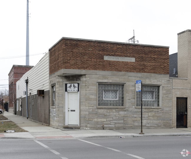
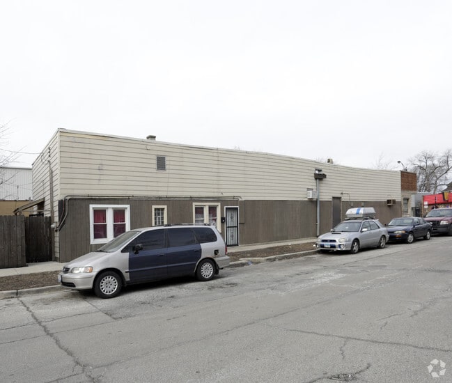
Property Record
2701 W 47Th St, Chicago, IL 60632
Current Lease Availabilities
NEARBY LISTINGS FOR SALE OR LEASE
Property Detail
2701 W 47Th St
Miscresidentialimprovement
Cook
X
Illinois
17031C0515J
0.07 AC
2023
Brighton Park
2024
Chicago
842800
Chicago-Naperville-Elgin, IL-IN-WI
2,750 SF
19-12-201-006-0000
DEMOGRAPHICS near 2701 W 47Th St
1 Mile
3 Mile
5 Mile
2024 Total Population
39,285
276,903
747,011
2029 Population
35,231
255,457
703,555
Pop Growth 2024-2029
(10.32%)
(7.74%)
(5.82%)
Average Age
35
36
37
2024 Total Households
11,229
82,584
259,640
HH Growth 2024-2029
(10.86%)
(8.24%)
(5.91%)
Median Household Inc
$43,720
$43,468
$45,331
Avg Household Size
3.30
3.10
2.70
2024 Avg HH Vehicles
1.00
1.00
1.00
Median Home Value
$210,642
$214,015
$228,629
Median Year Built
1947
1948
1950
Nearby Places
- Restaurants
- Banks
- Shops
- Fitness
- Groceries
PUBLIC TRANSPORTATION
TRANSIT/SUBWAY
Western Station (Orange Line) (Orange Line - Chicago Transit Authority "L" Trains (The "L"))
DRIVE
WALK
Distance
Western Station (Orange Line) (Orange Line - Chicago Transit Authority "L" Trains (The "L"))
1 min
12 min
0.6 mi
Kedzie Station (Orange Line) (Orange Line - Chicago Transit Authority "L" Trains (The "L"))
DRIVE
WALK
Distance
Kedzie Station (Orange Line) (Orange Line - Chicago Transit Authority "L" Trains (The "L"))
1 min
17 min
0.9 mi
COMMUTER RAIL
Western Avenue Station (Bnsf) (Burlington Northern-Santa Fe Railway Line - Northeast Illinois Regional Commuter Railroad (Metra))
DRIVE
WALK
Distance
Western Avenue Station (Bnsf) (Burlington Northern-Santa Fe Railway Line - Northeast Illinois Regional Commuter Railroad (Metra))
7 min
3.8 mi
35Th St. - Lou Jones (Rock Island - Metra)
DRIVE
WALK
Distance
35Th St. - Lou Jones (Rock Island - Metra)
9 min
4.6 mi
AIRPORT
Chicago Midway International
DRIVE
WALK
Distance
Chicago Midway International
7 min
3.8 mi
Chicago O'Hare International
DRIVE
WALK
Distance
Chicago O'Hare International
37 min
22.8 mi
Freight Ports
Port Milwaukee
DRIVE
WALK
Distance
Port Milwaukee
115 min
91.0 mi
Nearby Properties
Address
Land Use
TOTAL SIZE
Lot Size
Zoning
Address
Land Use
TOTAL SIZE
Lot Size
Zoning
474,979 SF
29.67 AC
PD 553
Address
Land Use
TOTAL SIZE
Lot Size
Zoning
4.71 AC
PD 1196
Address
Land Use
TOTAL SIZE
Lot Size
Zoning
2.98 AC
PD 1196
Address
Land Use
TOTAL SIZE
Lot Size
Zoning
134,800 SF
2.53 AC
PD 1273
Address
Land Use
TOTAL SIZE
Lot Size
Zoning
1,269,112 SF
39.99 AC
M2-1
Address
Land Use
TOTAL SIZE
Lot Size
Zoning
27.31 AC
PD 1424
Address
Land Use
TOTAL SIZE
Lot Size
Zoning
133,354 SF
PD 1198
Address
Land Use
TOTAL SIZE
Lot Size
Zoning
290,798 SF
23.70 AC
Address
Land Use
TOTAL SIZE
Lot Size
Zoning
169,435 SF
11.35 AC
PD 307
Address
Land Use
TOTAL SIZE
Lot Size
Zoning
307,277 SF
9.90 AC
PMD 11
Address
Land Use
TOTAL SIZE
Lot Size
Zoning
475,000 SF
14.01 AC
PMD 8
Address
Land Use
TOTAL SIZE
Lot Size
Zoning
0.84 AC
B1-3
Address
Land Use
TOTAL SIZE
Lot Size
Zoning
633,057 SF
34.96 AC
PMD 8
Address
Land Use
TOTAL SIZE
Lot Size
Zoning
72,893 SF
4.43 AC
PD 90
Address
Land Use
TOTAL SIZE
Lot Size
Zoning
1,023,467 SF
21.45 AC
PD 1424
Address
Land Use
TOTAL SIZE
Lot Size
Zoning
283,180 SF
1.41 AC
M2-3
Address
Land Use
TOTAL SIZE
Lot Size
Zoning
131,261 SF
7.04 AC
PD 172
Address
Land Use
TOTAL SIZE
Lot Size
Zoning
151,303 SF
0.88 AC
PD 568
Address
Land Use
TOTAL SIZE
Lot Size
Zoning
1.65 AC
B2-3
Address
Land Use
TOTAL SIZE
Lot Size
Zoning
310,775 SF
12.46 AC
M2-3
Address
Land Use
TOTAL SIZE
Lot Size
Zoning
460,333 SF
2.62 AC
C2-3
Address
Land Use
TOTAL SIZE
Lot Size
Zoning
160,487 SF
3.06 AC
PMD 11
Address
Land Use
TOTAL SIZE
Lot Size
Zoning
307,400 SF
7.89 AC
M2-3
Address
Land Use
TOTAL SIZE
Lot Size
Zoning
9.54 AC
PD 663
Address
Land Use
TOTAL SIZE
Lot Size
Zoning
113,143 SF
PMD 8
Address
Land Use
TOTAL SIZE
Lot Size
Zoning
435,677 SF
12.37 AC
M1-2
Address
Land Use
TOTAL SIZE
Lot Size
Zoning
15.16 AC
M3-3
Address
Land Use
TOTAL SIZE
Lot Size
Zoning
85,990 SF
6.46 AC
PD 411
Address
Land Use
TOTAL SIZE
Lot Size
Zoning
352,529 SF
12.77 AC
PMD 8
Address
Land Use
TOTAL SIZE
Lot Size
Zoning
273,975 SF
7.22 AC
M1-1
The World's #1 Commercial Real Estate Marketplace
Connect with us
© 2025 CoStar Group
The information above has been obtained from sources believed reliable. While we do not doubt its accuracy we have not verified it and make no guarantee, warranty or representation about it. It is your responsibility to independently confirm its accuracy and completeness. Any projections, opinions, assumptions, or estimates used are for example only and do not represent the current or future performance of the property. The value of this transaction to you depends on tax and other factors which should be evaluated by your tax, financial, and legal advisors. You and your advisors should conduct a careful, independent investigation of the property to determine to your satisfaction the suitability of the property for your needs.