Property Record
2702 Neville Rd, Pittsburgh, PA 15225
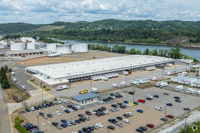


Property Detail
2702 Neville Rd
Pittsburgh, PA
N.I.A. PLAN B IRREG LOT = (15.675 ALD) (OR 682,803 SF) WOLF DR
0158-C-00125-0000-00
ALLEGHENY
Truckterminal
Pennsylvania
B and X Area of moderate flood hazard, usually the area between the limits of the 100-year and 500-year floods.
125
2026
15.68 AC
2026
West Pittsburgh
461000
Pittsburgh
NEARBY LISTINGS FOR SALE OR LEASE
DEMOGRAPHICS near 2702 Neville Rd
1 mile
3 mile
5 mile
2025 Total Population
4,509
54,347
156,066
2030 Population
4,380
53,423
154,018
Pop Growth 2025-2030
(2.86%)
(1.70%)
(1.31%)
Average Age
41
42
42
2025 Total Households
1,941
24,538
69,463
HH Growth 2025-2030
(2.94%)
(1.82%)
(1.40%)
Median Household Inc
$82,211
$71,444
$73,437
Avg Household Size
2.30
2.20
2.20
2025 Avg HH Vehicles
2.00
1.00
2.00
Median Home Value
$261,333
$227,883
$235,707
Median Year Built
1948
1955
1956
Nearby Places
Map Layers
Map Styles
 Street
 Aerial
Layers
 Traffic
 Biking
Places
Listings with unknown addresses are not visible on the map
- Restaurants
- Banks
- Shops
- Fitness
- Groceries
PUBLIC TRANSPORTATION
COMMUTER RAIL
Pittsburgh Amtrak Station (Capitol Limited - Amtrak, Pennsylvanian - Amtrak)
Drive
Walk
Distance
Pittsburgh Amtrak Station (Capitol Limited - Amtrak, Pennsylvanian - Amtrak)
17 min
8.2 mi
AIRPORT
Pittsburgh International
Drive
Walk
Distance
Pittsburgh International
25 min
10.0 mi
Freight Ports
Port of Toledo
Drive
Walk
Distance
Port of Toledo
262 min
227.1 mi
Nearby Properties
Address
Land Use
TOTAL SIZE
Lot Size
Zoning
Address
Land Use
TOTAL SIZE
Lot Size
Zoning
105.09 AC
Address
Land Use
TOTAL SIZE
Lot Size
Zoning
24.53 AC
Address
Land Use
TOTAL SIZE
Lot Size
Zoning
25.70 AC
Address
Land Use
TOTAL SIZE
Lot Size
Zoning
Address
Land Use
TOTAL SIZE
Lot Size
Zoning
45.85 AC
Address
Land Use
TOTAL SIZE
Lot Size
Zoning
25.09 AC
Address
Land Use
TOTAL SIZE
Lot Size
Zoning
88.84 AC
Address
Land Use
TOTAL SIZE
Lot Size
Zoning
6.52 AC
Address
Land Use
TOTAL SIZE
Lot Size
Zoning
Address
Land Use
TOTAL SIZE
Lot Size
Zoning
8.31 AC
Address
Land Use
TOTAL SIZE
Lot Size
Zoning
42.80 AC
Address
Land Use
TOTAL SIZE
Lot Size
Zoning
Address
Land Use
TOTAL SIZE
Lot Size
Zoning
5.58 AC
Address
Land Use
TOTAL SIZE
Lot Size
Zoning
Address
Land Use
TOTAL SIZE
Lot Size
Zoning
48.63 AC
Address
Land Use
TOTAL SIZE
Lot Size
Zoning
2,198 SF
4.05 AC
Address
Land Use
TOTAL SIZE
Lot Size
Zoning
Address
Land Use
TOTAL SIZE
Lot Size
Zoning
8.69 AC
Address
Land Use
TOTAL SIZE
Lot Size
Zoning
45.06 AC
Address
Land Use
TOTAL SIZE
Lot Size
Zoning
4.76 AC
Address
Land Use
TOTAL SIZE
Lot Size
Zoning
Address
Land Use
TOTAL SIZE
Lot Size
Zoning
43.12 AC
Address
Land Use
TOTAL SIZE
Lot Size
Zoning
11.79 AC
Address
Land Use
TOTAL SIZE
Lot Size
Zoning
Address
Land Use
TOTAL SIZE
Lot Size
Zoning
Address
Land Use
TOTAL SIZE
Lot Size
Zoning
Address
Land Use
TOTAL SIZE
Lot Size
Zoning
30.23 AC
Address
Land Use
TOTAL SIZE
Lot Size
Zoning
31.89 AC
Address
Land Use
TOTAL SIZE
Lot Size
Zoning
The World's #1 Commercial Real Estate Marketplace
Connect with us
© 2026 CoStar Group
The information above has been obtained from sources believed reliable. While we do not doubt its accuracy we have not verified it and make no guarantee, warranty or representation about it. It is your responsibility to independently confirm its accuracy and completeness. Any projections, opinions, assumptions, or estimates used are for example only and do not represent the current or future performance of the property. The value of this transaction to you depends on tax and other factors which should be evaluated by your tax, financial, and legal advisors. You and your advisors should conduct a careful, independent investigation of the property to determine to your satisfaction the suitability of the property for your needs.