Property Record
2703 29Th Ave E, Bradenton, FL 34208
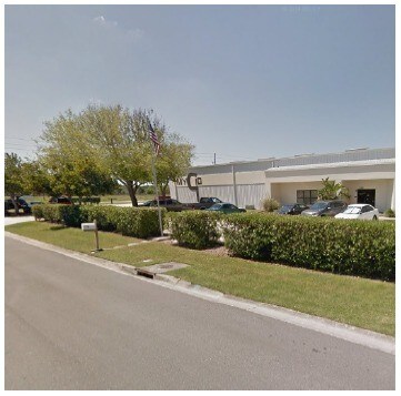
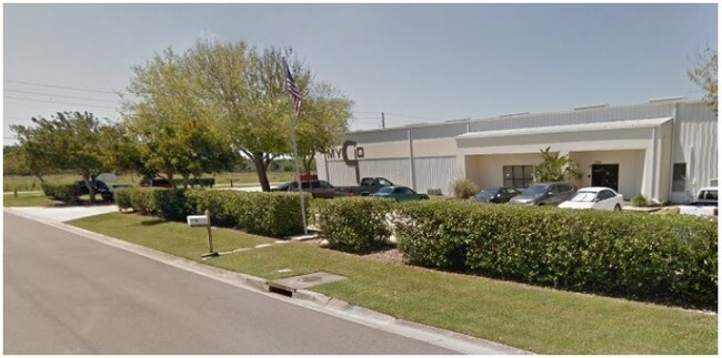

Property Detail
2703 29Th Ave E
North Port-Bradenton-Sarasota, FL
LOTS 1 & 2 BLK A UNITED INDUSTRIAL PARK; LESS INST#202341128210 & CORRECTED IN INST#202341132236 FOR R/W DESC AS FOLLOWS: A PARCEL OF LAND BEING A PORTION OF LOT 1,
15423-0022-1
Manatee
Commercialacreage
Florida
LM LIGHT M
1
B and X Area of moderate flood hazard, usually the area between the limits of the 100-year and 500-year floods.
0.31 AC
2024
Manatee
2025
Tampa/St Petersburg
000812
NEARBY LISTINGS FOR SALE OR LEASE
DEMOGRAPHICS near 2703 29Th Ave E
1 mile
3 mile
5 mile
2025 Total Population
9,144
79,600
212,618
2030 Population
10,291
88,789
237,104
Pop Growth 2025-2030
+ 12.54%
+ 11.54%
+ 11.52%
Average Age
39
43
45
2025 Total Households
3,079
31,784
89,270
HH Growth 2025-2030
+ 12.76%
+ 11.90%
+ 11.85%
Median Household Inc
$66,433
$56,386
$61,777
Avg Household Size
2.80
2.40
2.30
2025 Avg HH Vehicles
2.00
2.00
2.00
Median Home Value
$311,650
$291,483
$307,450
Median Year Built
1995
1986
1985
Nearby Places
Map Layers
Map Styles
 Street
 Aerial
Transit
 Traffic
 Biking
Places
Listings with unknown addresses are not visible on the map
- Restaurants
- Banks
- Shops
- Fitness
- Groceries
PUBLIC TRANSPORTATION
AIRPORT
Sarasota/Bradenton International
Drive
Walk
Distance
Sarasota/Bradenton International
17 min
8.9 mi
Freight Ports
Port Manatee
Drive
Walk
Distance
Port Manatee
25 min
14.3 mi
SALE & LEASE HISTORY
LISTING DATE
SALE/LEASE

Jul 17, 2019
For Sale
Nearby Properties
Address
Land Use
TOTAL SIZE
Lot Size
Zoning
Address
Land Use
TOTAL SIZE
Lot Size
Zoning
881,490 SF
83.09 AC
BR_R-3
Address
Land Use
TOTAL SIZE
Lot Size
Zoning
595,475 SF
16.90 AC
BR_T5
Address
Land Use
TOTAL SIZE
Lot Size
Zoning
349,711 SF
49.51 AC
BR_SD1
Address
Land Use
TOTAL SIZE
Lot Size
Zoning
405,843 SF
9.09 AC
BR_T5
Address
Land Use
TOTAL SIZE
Lot Size
Zoning
277,678 SF
7.80 AC
BR_T4-O, B
Address
Land Use
TOTAL SIZE
Lot Size
Zoning
319,679 SF
31.78 AC
BR_R-1
Address
Land Use
TOTAL SIZE
Lot Size
Zoning
318,507 SF
10.47 AC
BR_T4R,BR_
Address
Land Use
TOTAL SIZE
Lot Size
Zoning
2,401,721 SF
142.14 AC
PD-UI
Address
Land Use
TOTAL SIZE
Lot Size
Zoning
311,669 SF
34.55 AC
BR_R-2
Address
Land Use
TOTAL SIZE
Lot Size
Zoning
225,768 SF
18.47 AC
BR_R-1
Address
Land Use
TOTAL SIZE
Lot Size
Zoning
257,072 SF
10.07 AC
BR_T5
Address
Land Use
TOTAL SIZE
Lot Size
Zoning
375,171 SF
20 AC
PD-MU
Address
Land Use
TOTAL SIZE
Lot Size
Zoning
397,863 SF
21.60 AC
GC GENERA
Address
Land Use
TOTAL SIZE
Lot Size
Zoning
541,781 SF
3.48 AC
BR_T5
Address
Land Use
TOTAL SIZE
Lot Size
Zoning
115,400 SF
22.55 AC
LM LIGHT M
Address
Land Use
TOTAL SIZE
Lot Size
Zoning
348,901 SF
27 AC
BR_R-2
Address
Land Use
TOTAL SIZE
Lot Size
Zoning
185,617 SF
13.68 AC
BR_R-2
Address
Land Use
TOTAL SIZE
Lot Size
Zoning
187,000 SF
8.93 AC
Address
Land Use
TOTAL SIZE
Lot Size
Zoning
166,810 SF
3.16 AC
BR_T4-O
Address
Land Use
TOTAL SIZE
Lot Size
Zoning
214,350 SF
16.07 AC
LM LIGHT M
Address
Land Use
TOTAL SIZE
Lot Size
Zoning
296,983 SF
34.84 AC
PD-MU
Address
Land Use
TOTAL SIZE
Lot Size
Zoning
485,150 SF
56.44 AC
HC,GC
Address
Land Use
TOTAL SIZE
Lot Size
Zoning
901,196 SF
48.54 AC
LM LIGHT M
Address
Land Use
TOTAL SIZE
Lot Size
Zoning
145,200 SF
8.66 AC
Address
Land Use
TOTAL SIZE
Lot Size
Zoning
148,992 SF
9.81 AC
RMF-9,GC
Address
Land Use
TOTAL SIZE
Lot Size
Zoning
419,956 SF
18.46 AC
LM LIGHT M
Address
Land Use
TOTAL SIZE
Lot Size
Zoning
145,200 SF
8.99 AC
Address
Land Use
TOTAL SIZE
Lot Size
Zoning
157,713 SF
12.84 AC
GC GENERA
Address
Land Use
TOTAL SIZE
Lot Size
Zoning
124,129 SF
23.29 AC
PDC
Address
Land Use
TOTAL SIZE
Lot Size
Zoning
143,582 SF
14.42 AC
LM LIGHT M
The World's #1 Commercial Real Estate Marketplace
Connect with us
© 2026 CoStar Group
The information above has been obtained from sources believed reliable. While we do not doubt its accuracy we have not verified it and make no guarantee, warranty or representation about it. It is your responsibility to independently confirm its accuracy and completeness. Any projections, opinions, assumptions, or estimates used are for example only and do not represent the current or future performance of the property. The value of this transaction to you depends on tax and other factors which should be evaluated by your tax, financial, and legal advisors. You and your advisors should conduct a careful, independent investigation of the property to determine to your satisfaction the suitability of the property for your needs.