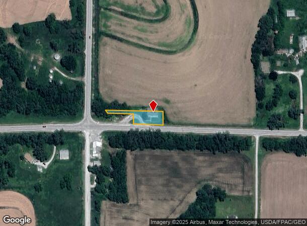
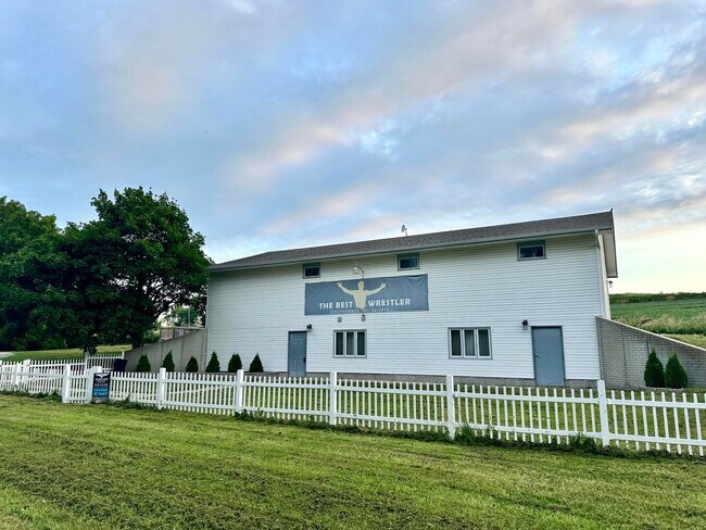
Property Record
27046 Highway 6, Mc Clelland, IA 51548

Current Lease Availabilities
NEARBY LISTINGS FOR SALE OR LEASE
-
-
View all Mc Clelland listings for lease on LoopNet.com
Property Detail
27046 Highway 6
7542-15-300-004
HARDIN TWP 15-75-42 S108.14' W338.58' SW SW N & E OF RDS
Hotelormotel
Pottawattamie
X
Iowa
19155C0450F
0.37 AC
2025
W Pottawattamie County
2025
Omaha/Council Bluffs
021603
Omaha-Council Bluffs, NE-IA
4,320 SF
DEMOGRAPHICS near 27046 Highway 6
1 Mile
3 Mile
5 Mile
2024 Total Population
43
823
3,158
2029 Population
42
816
3,135
Pop Growth 2024-2029
(2.33%)
(0.85%)
(0.73%)
Average Age
42
42
42
2024 Total Households
15
299
1,152
HH Growth 2024-2029
0.00%
(1.00%)
(0.69%)
Median Household Inc
$106,250
$101,744
$110,907
Avg Household Size
2.40
2.70
2.70
2024 Avg HH Vehicles
3.00
3.00
3.00
Median Home Value
$333,333
$332,727
$323,261
Median Year Built
1959
1973
1976
Nearby Places
- Restaurants
- Banks
- Shops
- Fitness
- Groceries
PUBLIC TRANSPORTATION
AIRPORT
Eppley Airfield
DRIVE
WALK
Distance
Eppley Airfield
32 min
20.5 mi
Nearby Properties
Address
Land Use
TOTAL SIZE
Lot Size
Zoning
Address
Land Use
TOTAL SIZE
Lot Size
Zoning
6,800 SF
2.76 AC
C-2
Address
Land Use
TOTAL SIZE
Lot Size
Zoning
Address
Land Use
TOTAL SIZE
Lot Size
Zoning
6,660 SF
0.80 AC
Address
Land Use
TOTAL SIZE
Lot Size
Zoning
4.78 AC
R-1
Address
Land Use
TOTAL SIZE
Lot Size
Zoning
1,384 SF
34.85 AC
R-1
Address
Land Use
TOTAL SIZE
Lot Size
Zoning
5,015 SF
0.77 AC
Address
Land Use
TOTAL SIZE
Lot Size
Zoning
0.16 AC
Address
Land Use
TOTAL SIZE
Lot Size
Zoning
3,108 SF
0.32 AC
Address
Land Use
TOTAL SIZE
Lot Size
Zoning
3,120 SF
0.24 AC
Address
Land Use
TOTAL SIZE
Lot Size
Zoning
0.24 AC
Address
Land Use
TOTAL SIZE
Lot Size
Zoning
1,216 SF
39 AC
R-1
Address
Land Use
TOTAL SIZE
Lot Size
Zoning
808 SF
34 AC
R-1
Address
Land Use
TOTAL SIZE
Lot Size
Zoning
36.98 AC
R-1
Address
Land Use
TOTAL SIZE
Lot Size
Zoning
38.80 AC
R-1
Address
Land Use
TOTAL SIZE
Lot Size
Zoning
3,710 SF
0.93 AC
R-1
Address
Land Use
TOTAL SIZE
Lot Size
Zoning
0.99 AC
R-1
Address
Land Use
TOTAL SIZE
Lot Size
Zoning
0.24 AC
Address
Land Use
TOTAL SIZE
Lot Size
Zoning
1,472 SF
34.48 AC
R-1
Address
Land Use
TOTAL SIZE
Lot Size
Zoning
39 AC
R-1
Address
Land Use
TOTAL SIZE
Lot Size
Zoning
1,224 SF
40 AC
R-1
Address
Land Use
TOTAL SIZE
Lot Size
Zoning
33.81 AC
R-1
Address
Land Use
TOTAL SIZE
Lot Size
Zoning
28.93 AC
R-1
Address
Land Use
TOTAL SIZE
Lot Size
Zoning
40 AC
R-1
The World's #1 Commercial Real Estate Marketplace
Connect with us
© 2025 CoStar Group
The information above has been obtained from sources believed reliable. While we do not doubt its accuracy we have not verified it and make no guarantee, warranty or representation about it. It is your responsibility to independently confirm its accuracy and completeness. Any projections, opinions, assumptions, or estimates used are for example only and do not represent the current or future performance of the property. The value of this transaction to you depends on tax and other factors which should be evaluated by your tax, financial, and legal advisors. You and your advisors should conduct a careful, independent investigation of the property to determine to your satisfaction the suitability of the property for your needs.