Property Record
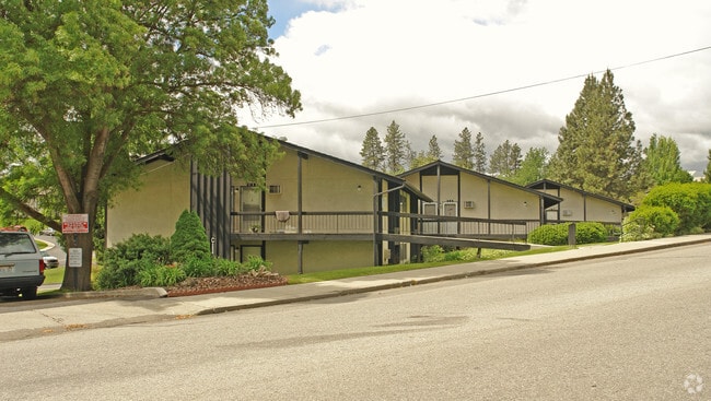
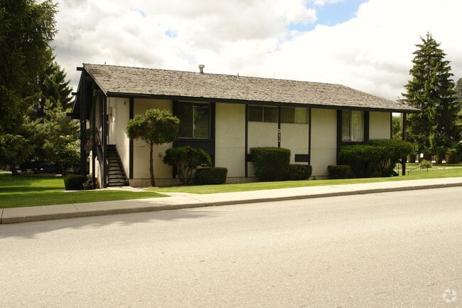
2705 E 29Th Ave, Spokane, WA 99223

Property Detail
2705 E 29Th Ave
35284.0175
DESSERT 5 AC TRS TR 14 & TR 15 EXC E30FT AND EXC ST
Apartment
Spokane
RMF
Washington
C and X Area of minimal flood hazard, usually depicted on FIRMs as above the 500-year flood level.
7.49 AC
2025
Lincoln Heights
2025
Spokane
004601
Spokane-Spokane Valley, WA
55,232 SF
NEARBY LISTINGS FOR SALE OR LEASE
DEMOGRAPHICS near 2705 E 29Th Ave
1 mile
3 mile
5 mile
2025 Total Population
14,952
85,205
177,369
2030 Population
15,191
86,871
180,662
Pop Growth 2025-2030
+ 1.60%
+ 1.96%
+ 1.86%
Average Age
43
41
40
2025 Total Households
6,447
36,008
74,463
HH Growth 2025-2030
+ 1.78%
+ 2.13%
+ 2.06%
Median Household Inc
$77,033
$76,130
$66,918
Avg Household Size
2.20
2.20
2.20
2025 Avg HH Vehicles
2.00
2.00
2.00
Median Home Value
$439,113
$462,645
$403,097
Median Year Built
1977
1974
1970
Nearby Places
Map Layers
Map Styles
 Street
 Aerial
Layers
 Traffic
 Biking
Places
Listings with unknown addresses are not visible on the map
- Restaurants
- Banks
- Shops
- Fitness
- Groceries
PUBLIC TRANSPORTATION
COMMUTER RAIL
Drive
Walk
Distance
10 min
3.6 mi
AIRPORT
Spokane International
Drive
Walk
Distance
Spokane International
19 min
9.7 mi
Nearby Properties
Address
Land Use
TOTAL SIZE
Lot Size
Zoning
Address
Land Use
TOTAL SIZE
Lot Size
Zoning
763,627 SF
12.44 AC
OR
Address
Land Use
TOTAL SIZE
Lot Size
Zoning
481,348 SF
17.09 AC
DTU
Address
Land Use
TOTAL SIZE
Lot Size
Zoning
226,702 SF
49.25 AC
RSF
Address
Land Use
TOTAL SIZE
Lot Size
Zoning
365,804 SF
16.13 AC
RSF
Address
Land Use
TOTAL SIZE
Lot Size
Zoning
251,542 SF
5.78 AC
DTG
Address
Land Use
TOTAL SIZE
Lot Size
Zoning
270,262 SF
29.10 AC
Address
Land Use
TOTAL SIZE
Lot Size
Zoning
218,684 SF
13.29 AC
RMF
Address
Land Use
TOTAL SIZE
Lot Size
Zoning
91,882 SF
2.07 AC
OR
Address
Land Use
TOTAL SIZE
Lot Size
Zoning
124,234 SF
13.54 AC
RSF
Address
Land Use
TOTAL SIZE
Lot Size
Zoning
210,277 SF
19.18 AC
RMF
Address
Land Use
TOTAL SIZE
Lot Size
Zoning
289,705 SF
3.36 AC
OR
Address
Land Use
TOTAL SIZE
Lot Size
Zoning
137,503 SF
17.31 AC
GC
Address
Land Use
TOTAL SIZE
Lot Size
Zoning
290,380 SF
2.11 AC
CA3
Address
Land Use
TOTAL SIZE
Lot Size
Zoning
107,240 SF
1.54 AC
CC1
Address
Land Use
TOTAL SIZE
Lot Size
Zoning
289,573 SF
7.73 AC
RMF
Address
Land Use
TOTAL SIZE
Lot Size
Zoning
91,310 SF
2.34 AC
Address
Land Use
TOTAL SIZE
Lot Size
Zoning
135,715 SF
4.73 AC
RMF
Address
Land Use
TOTAL SIZE
Lot Size
Zoning
108,237 SF
3.48 AC
LI
Address
Land Use
TOTAL SIZE
Lot Size
Zoning
58,522 SF
19.91 AC
HI
Address
Land Use
TOTAL SIZE
Lot Size
Zoning
91,048 SF
3.81 AC
OR
Address
Land Use
TOTAL SIZE
Lot Size
Zoning
119,933 SF
5.61 AC
Address
Land Use
TOTAL SIZE
Lot Size
Zoning
127,826 SF
0.33 AC
DTG
Address
Land Use
TOTAL SIZE
Lot Size
Zoning
138,840 SF
2.79 AC
DTU
Address
Land Use
TOTAL SIZE
Lot Size
Zoning
159,720 SF
6.84 AC
RMF
Address
Land Use
TOTAL SIZE
Lot Size
Zoning
155,133 SF
3.76 AC
RHD
Address
Land Use
TOTAL SIZE
Lot Size
Zoning
41,890 SF
2.11 AC
OR
Address
Land Use
TOTAL SIZE
Lot Size
Zoning
66,193 SF
1.99 AC
OR
Address
Land Use
TOTAL SIZE
Lot Size
Zoning
77,694 SF
4.63 AC
RHD
Address
Land Use
TOTAL SIZE
Lot Size
Zoning
78,990 SF
5.58 AC
RSF
Address
Land Use
TOTAL SIZE
Lot Size
Zoning
79,200 SF
OR
The World's #1 Commercial Real Estate Marketplace
Connect with us
© 2026 CoStar Group
The information above has been obtained from sources believed reliable. While we do not doubt its accuracy we have not verified it and make no guarantee, warranty or representation about it. It is your responsibility to independently confirm its accuracy and completeness. Any projections, opinions, assumptions, or estimates used are for example only and do not represent the current or future performance of the property. The value of this transaction to you depends on tax and other factors which should be evaluated by your tax, financial, and legal advisors. You and your advisors should conduct a careful, independent investigation of the property to determine to your satisfaction the suitability of the property for your needs.