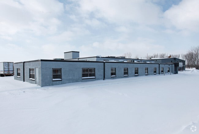
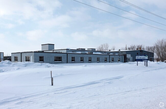
Property Record
2705 Highway 55, Hamel, MN 55340
NEARBY LISTINGS FOR SALE OR LEASE
Property Detail
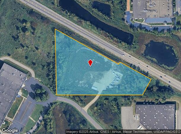
2705 Highway 55
Minneapolis-St. Paul-Bloomington, MN-WI
Unplatted 04 118 23
04-118-23-13-0006
UNPLATTED 04 118 23 THAT PART OF THE SW 1/4 OF THE NE 1/4 LYING SWLY OF THE SWLY R/W LINE OF STATE HWY NO 55 AND LYING WLY OF A LINE RUNNING FROM A PT ON SAID SWLY T IRREGULAR
Industrialacreage
Hennepin
X
Minnesota
27053C0165F
7.44 AC
2024
Southwest
2024
Minneapolis/St Paul
027101
DEMOGRAPHICS near 2705 Highway 55
1 Mile
3 Mile
5 Mile
2024 Total Population
239
5,339
37,577
2029 Population
234
5,242
37,431
Pop Growth 2024-2029
(2.09%)
(1.82%)
(0.39%)
Average Age
41
40
38
2024 Total Households
80
1,801
12,598
HH Growth 2024-2029
(2.50%)
(1.94%)
(0.61%)
Median Household Inc
$151,562
$170,479
$170,843
Avg Household Size
3.00
2.90
2.90
2024 Avg HH Vehicles
3.00
2.00
2.00
Median Home Value
$615,384
$602,711
$596,783
Median Year Built
1978
1993
2001
Nearby Places
Map Layers
Map Styles
 Street
 Aerial
- Restaurants
- Banks
- Shops
- Fitness
- Groceries
PUBLIC TRANSPORTATION
AIRPORT
Minneapolis-St Paul International/Wold-Chamberlain
DRIVE
WALK
Distance
Minneapolis-St Paul International/Wold-Chamberlain
44 min
29.9 mi
Nearby Properties
Address
Land Use
TOTAL SIZE
Lot Size
Zoning
Address
Land Use
TOTAL SIZE
Lot Size
Zoning
21.09 AC
Address
Land Use
TOTAL SIZE
Lot Size
Zoning
Address
Land Use
TOTAL SIZE
Lot Size
Zoning
25.53 AC
Address
Land Use
TOTAL SIZE
Lot Size
Zoning
32.70 AC
Address
Land Use
TOTAL SIZE
Lot Size
Zoning
25.11 AC
Address
Land Use
TOTAL SIZE
Lot Size
Zoning
33.02 AC
Address
Land Use
TOTAL SIZE
Lot Size
Zoning
42.54 AC
Address
Land Use
TOTAL SIZE
Lot Size
Zoning
26.54 AC
Address
Land Use
TOTAL SIZE
Lot Size
Zoning
11.52 AC
Address
Land Use
TOTAL SIZE
Lot Size
Zoning
10.79 AC
Address
Land Use
TOTAL SIZE
Lot Size
Zoning
9.82 AC
Address
Land Use
TOTAL SIZE
Lot Size
Zoning
3.85 AC
Address
Land Use
TOTAL SIZE
Lot Size
Zoning
Address
Land Use
TOTAL SIZE
Lot Size
Zoning
198.87 AC
Address
Land Use
TOTAL SIZE
Lot Size
Zoning
16.62 AC
Address
Land Use
TOTAL SIZE
Lot Size
Zoning
5.07 AC
Address
Land Use
TOTAL SIZE
Lot Size
Zoning
2.01 AC
Address
Land Use
TOTAL SIZE
Lot Size
Zoning
4.87 AC
Address
Land Use
TOTAL SIZE
Lot Size
Zoning
10.29 AC
Address
Land Use
TOTAL SIZE
Lot Size
Zoning
15.21 AC
Address
Land Use
TOTAL SIZE
Lot Size
Zoning
8.67 AC
Address
Land Use
TOTAL SIZE
Lot Size
Zoning
10.01 AC
Address
Land Use
TOTAL SIZE
Lot Size
Zoning
17.91 AC
Address
Land Use
TOTAL SIZE
Lot Size
Zoning
2.02 AC
Address
Land Use
TOTAL SIZE
Lot Size
Zoning
1.08 AC
Address
Land Use
TOTAL SIZE
Lot Size
Zoning
7.12 AC
Address
Land Use
TOTAL SIZE
Lot Size
Zoning
3.28 AC
Address
Land Use
TOTAL SIZE
Lot Size
Zoning
0.95 AC
Address
Land Use
TOTAL SIZE
Lot Size
Zoning
4.59 AC
Address
Land Use
TOTAL SIZE
Lot Size
Zoning
8.40 AC
The World's #1 Commercial Real Estate Marketplace
Connect with us
© 2025 CoStar Group
The information above has been obtained from sources believed reliable. While we do not doubt its accuracy we have not verified it and make no guarantee, warranty or representation about it. It is your responsibility to independently confirm its accuracy and completeness. Any projections, opinions, assumptions, or estimates used are for example only and do not represent the current or future performance of the property. The value of this transaction to you depends on tax and other factors which should be evaluated by your tax, financial, and legal advisors. You and your advisors should conduct a careful, independent investigation of the property to determine to your satisfaction the suitability of the property for your needs.