Property Record
2706 Old Moultrie Rd, Saint Augustine, FL 32086
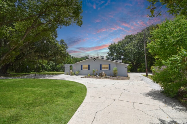


This Property Is For Sale
Current Lease Availabilities
Property Detail
2706 Old Moultrie Rd
162620-0000
20&21 5AC PT OF LOT 9 N225 OF S545FT(EX 50 X 100FT IN SW COR IN DB193/48 & OR1044/15)(EX E 400FT IN DB180/240)& N50 OF S370 OF W215FT(EX R/W OF RD #S 5-A IN DB228/393 & DB231/232) OR5312/186
Commercialnec
ST. JOHNS
CN
Florida
AE The base floodplain where base flood elevations are provided. AE Zones are now used on new format FIRMs instead of A1-A30 Zones.
9
2025
3.97 AC
2026
St Johns County
021301
Jacksonville (Florida)
2,276 SF
Jacksonville, FL
NEARBY LISTINGS FOR SALE OR LEASE
DEMOGRAPHICS near 2706 Old Moultrie Rd
1 mile
3 mile
5 mile
2025 Total Population
7,764
42,902
90,170
2030 Population
8,939
49,763
105,244
Pop Growth 2025-2030
+ 15.13%
+ 15.99%
+ 16.72%
Average Age
45
46
47
2025 Total Households
3,231
18,547
40,152
HH Growth 2025-2030
+ 15.54%
+ 16.38%
+ 17.22%
Median Household Inc
$70,036
$74,429
$77,933
Avg Household Size
2.30
2.20
2.20
2025 Avg HH Vehicles
2.00
2.00
2.00
Median Home Value
$403,838
$417,088
$442,456
Median Year Built
1993
1997
1996
Nearby Places
Map Layers
Map Styles
 Street
 Aerial
Transit
 Traffic
 Biking
Places
Listings with unknown addresses are not visible on the map
- Restaurants
- Banks
- Shops
- Fitness
- Groceries
Nearby Properties
Address
Land Use
TOTAL SIZE
Lot Size
Zoning
Address
Land Use
TOTAL SIZE
Lot Size
Zoning
117,686 SF
14.52 AC
CI
Address
Land Use
TOTAL SIZE
Lot Size
Zoning
532,530 SF
25.80 AC
CG
Address
Land Use
TOTAL SIZE
Lot Size
Zoning
438,417 SF
3.98 AC
Address
Land Use
TOTAL SIZE
Lot Size
Zoning
237,460 SF
66.83 AC
Address
Land Use
TOTAL SIZE
Lot Size
Zoning
209,356 SF
12.88 AC
RG-O
Address
Land Use
TOTAL SIZE
Lot Size
Zoning
311,794 SF
39.89 AC
Address
Land Use
TOTAL SIZE
Lot Size
Zoning
262,617 SF
37.08 AC
PUD
Address
Land Use
TOTAL SIZE
Lot Size
Zoning
130,186 SF
21.74 AC
CG
Address
Land Use
TOTAL SIZE
Lot Size
Zoning
167,306 SF
17.02 AC
CG
Address
Land Use
TOTAL SIZE
Lot Size
Zoning
52,990 SF
5.82 AC
OR
Address
Land Use
TOTAL SIZE
Lot Size
Zoning
161,211 SF
21.70 AC
PUD
Address
Land Use
TOTAL SIZE
Lot Size
Zoning
119,853 SF
21.34 AC
Address
Land Use
TOTAL SIZE
Lot Size
Zoning
65,082 SF
22.11 AC
Address
Land Use
TOTAL SIZE
Lot Size
Zoning
47,385 SF
12.36 AC
Address
Land Use
TOTAL SIZE
Lot Size
Zoning
2.46 AC
CI
Address
Land Use
TOTAL SIZE
Lot Size
Zoning
76,233 SF
10.94 AC
CG
Address
Land Use
TOTAL SIZE
Lot Size
Zoning
1,240 SF
29.76 AC
OR
Address
Land Use
TOTAL SIZE
Lot Size
Zoning
90,744 SF
5.47 AC
Address
Land Use
TOTAL SIZE
Lot Size
Zoning
15.71 AC
OR
Address
Land Use
TOTAL SIZE
Lot Size
Zoning
202,143 SF
22.30 AC
OR
Address
Land Use
TOTAL SIZE
Lot Size
Zoning
202,733 SF
23.38 AC
PUD
Address
Land Use
TOTAL SIZE
Lot Size
Zoning
196,920 SF
17.46 AC
PSD
Address
Land Use
TOTAL SIZE
Lot Size
Zoning
96,152 SF
6.79 AC
Address
Land Use
TOTAL SIZE
Lot Size
Zoning
138,830 SF
15 AC
OR
Address
Land Use
TOTAL SIZE
Lot Size
Zoning
700 SF
3.82 AC
CG
Address
Land Use
TOTAL SIZE
Lot Size
Zoning
111,836 SF
13.47 AC
CG
Address
Land Use
TOTAL SIZE
Lot Size
Zoning
126,267 SF
14.28 AC
IW/CG
Address
Land Use
TOTAL SIZE
Lot Size
Zoning
25,894 SF
8.34 AC
OR
Address
Land Use
TOTAL SIZE
Lot Size
Zoning
9,375 SF
30.15 AC
IW
Address
Land Use
TOTAL SIZE
Lot Size
Zoning
7,292 SF
7.21 AC
The World's #1 Commercial Real Estate Marketplace
Connect with us
© 2026 CoStar Group
The information above has been obtained from sources believed reliable. While we do not doubt its accuracy we have not verified it and make no guarantee, warranty or representation about it. It is your responsibility to independently confirm its accuracy and completeness. Any projections, opinions, assumptions, or estimates used are for example only and do not represent the current or future performance of the property. The value of this transaction to you depends on tax and other factors which should be evaluated by your tax, financial, and legal advisors. You and your advisors should conduct a careful, independent investigation of the property to determine to your satisfaction the suitability of the property for your needs.