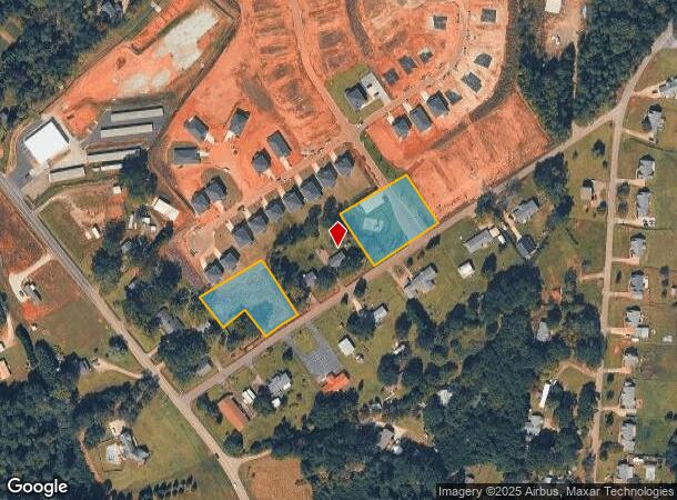
Property Record
2707 Pelzer Hwy, Easley, SC 29642
NEARBY LISTINGS FOR SALE OR LEASE
Property Detail
2707 Pelzer Hwy
188-00-03-002
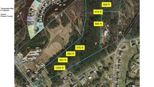
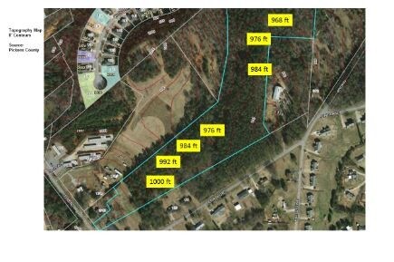
Plat For Sadie Irene Coats
Agriculturalland
CP 000/000 PP S 2902/4 F000 D000 PP S 2556/2 PELZER HWY 3.97 AC
X
Anderson
45007C0040E
South Carolina
2025
3.97 AC
2024
Anderson County
010107
Greenville/Spartanburg
2,395 SF
Greenville-Anderson-Mauldin, SC
DEMOGRAPHICS near 2707 Pelzer Hwy
1 Mile
3 Mile
5 Mile
2024 Total Population
1,973
21,785
55,561
2029 Population
2,088
22,920
58,441
Pop Growth 2024-2029
+ 5.83%
+ 5.21%
+ 5.18%
Average Age
40
41
41
2024 Total Households
712
8,312
21,735
HH Growth 2024-2029
+ 5.76%
+ 5.21%
+ 5.22%
Median Household Inc
$76,562
$68,872
$64,256
Avg Household Size
2.70
2.60
2.50
2024 Avg HH Vehicles
2.00
2.00
2.00
Median Home Value
$208,085
$232,157
$215,678
Median Year Built
1995
1992
1990
Nearby Places
Map Layers
Map Styles
 Street
 Aerial
- Restaurants
- Banks
- Shops
- Fitness
- Groceries
PUBLIC TRANSPORTATION
AIRPORT
Greenville Spartanburg International
DRIVE
WALK
Distance
Greenville Spartanburg International
44 min
29.9 mi
Freight Ports
North Charleston Terminal
DRIVE
WALK
Distance
North Charleston Terminal
247 min
214.1 mi
SALE & LEASE HISTORY
LISTING DATE
SALE/LEASE

Apr 29, 2019
For Sale
Nearby Properties
Address
Land Use
TOTAL SIZE
Lot Size
Zoning
Address
Land Use
TOTAL SIZE
Lot Size
Zoning
162.06 AC
R10
Address
Land Use
TOTAL SIZE
Lot Size
Zoning
177,695 SF
20.43 AC
Address
Land Use
TOTAL SIZE
Lot Size
Zoning
9,800 SF
5.94 AC
R10
Address
Land Use
TOTAL SIZE
Lot Size
Zoning
27.43 AC
R 10 ONE F
Address
Land Use
TOTAL SIZE
Lot Size
Zoning
42.26 AC
OFFICE INS
Address
Land Use
TOTAL SIZE
Lot Size
Zoning
3.98 AC
NEIGHBORHO
Address
Land Use
TOTAL SIZE
Lot Size
Zoning
55 AC
R 10 ONE F
Address
Land Use
TOTAL SIZE
Lot Size
Zoning
3,161 SF
0.34 AC
GENERAL RE
Address
Land Use
TOTAL SIZE
Lot Size
Zoning
7.06 AC
Address
Land Use
TOTAL SIZE
Lot Size
Zoning
1,904 SF
17.74 AC
R10
Address
Land Use
TOTAL SIZE
Lot Size
Zoning
8.03 AC
IND
Address
Land Use
TOTAL SIZE
Lot Size
Zoning
4,509 SF
0.97 AC
Address
Land Use
TOTAL SIZE
Lot Size
Zoning
38.67 AC
R10
Address
Land Use
TOTAL SIZE
Lot Size
Zoning
200 SF
10.92 AC
GENERAL CO
Address
Land Use
TOTAL SIZE
Lot Size
Zoning
1,800 SF
6.23 AC
Address
Land Use
TOTAL SIZE
Lot Size
Zoning
135,024 SF
10.50 AC
RM 2 TWO F
Address
Land Use
TOTAL SIZE
Lot Size
Zoning
13.60 AC
Address
Land Use
TOTAL SIZE
Lot Size
Zoning
78,576 SF
9.08 AC
Address
Land Use
TOTAL SIZE
Lot Size
Zoning
78,800 SF
7.94 AC
GENERAL RE
Address
Land Use
TOTAL SIZE
Lot Size
Zoning
5,730 SF
126.67 AC
R 10 ONE F
Address
Land Use
TOTAL SIZE
Lot Size
Zoning
29.30 AC
Address
Land Use
TOTAL SIZE
Lot Size
Zoning
1.68 AC
GENERAL RE
Address
Land Use
TOTAL SIZE
Lot Size
Zoning
3.75 AC
R10
Address
Land Use
TOTAL SIZE
Lot Size
Zoning
22,000 SF
4.35 AC
GENERAL CO
Address
Land Use
TOTAL SIZE
Lot Size
Zoning
9.05 AC
R 10 ONE F
Address
Land Use
TOTAL SIZE
Lot Size
Zoning
29.07 AC
Address
Land Use
TOTAL SIZE
Lot Size
Zoning
24,296 SF
6.31 AC
GENERAL RE
Address
Land Use
TOTAL SIZE
Lot Size
Zoning
8,480 SF
2.66 AC
R10
Address
Land Use
TOTAL SIZE
Lot Size
Zoning
41.48 AC
GC
The World's #1 Commercial Real Estate Marketplace
Connect with us
© 2025 CoStar Group
The information above has been obtained from sources believed reliable. While we do not doubt its accuracy we have not verified it and make no guarantee, warranty or representation about it. It is your responsibility to independently confirm its accuracy and completeness. Any projections, opinions, assumptions, or estimates used are for example only and do not represent the current or future performance of the property. The value of this transaction to you depends on tax and other factors which should be evaluated by your tax, financial, and legal advisors. You and your advisors should conduct a careful, independent investigation of the property to determine to your satisfaction the suitability of the property for your needs.