Property Record
27079 Smiths Ferry Rd, Franklin, VA 23851

This Property Is For Sale
NEARBY LISTINGS FOR SALE OR LEASE
Property Detail
27079 Smiths Ferry Rd
Sfr
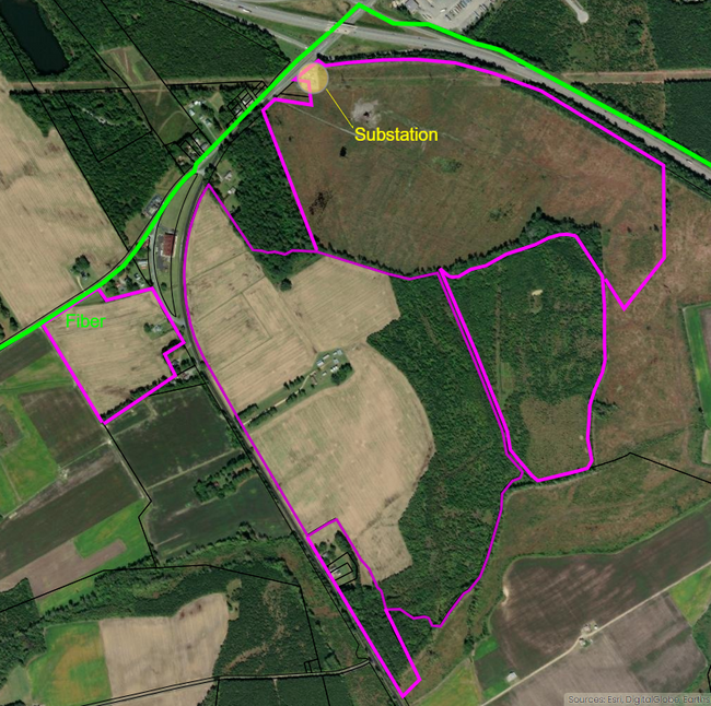
WETLANDS MITIGATION AREA
X
Southampton
5100600003D
Virginia
2025
113.33 AC
2025
Virginia Regional
090100
Other Market Areas
1,431 SF
93-11
DEMOGRAPHICS near 27079 Smiths Ferry Rd
1 mile
3 mile
5 mile
2024 Total Population
613
8,426
12,307
2029 Population
611
8,437
12,374
Pop Growth 2024-2029
(0.33%)
+ 0.13%
+ 0.54%
Average Age
40
42
43
2024 Total Households
270
3,534
5,136
HH Growth 2024-2029
(0.37%)
+ 0.17%
+ 0.62%
Median Household Inc
$27,500
$48,917
$55,686
Avg Household Size
2.20
2.40
2.40
2024 Avg HH Vehicles
1.00
2.00
2.00
Median Home Value
$138,043
$191,061
$193,516
Median Year Built
1972
1966
1971
Nearby Places
Map Layers
Map Styles
 Street
 Aerial
Transit
 Traffic
 Biking
Places
Listings with unknown addresses are not visible on the map
- Restaurants
- Banks
- Shops
- Fitness
- Groceries
Nearby Properties
Address
Land Use
TOTAL SIZE
Lot Size
Zoning
Address
Land Use
TOTAL SIZE
Lot Size
Zoning
1,370.72 AC
03
Address
Land Use
TOTAL SIZE
Lot Size
Zoning
142.47 AC
M-2
Address
Land Use
TOTAL SIZE
Lot Size
Zoning
122,516 SF
49.84 AC
R2
Address
Land Use
TOTAL SIZE
Lot Size
Zoning
60,000 SF
74.67 AC
R1
Address
Land Use
TOTAL SIZE
Lot Size
Zoning
105,606 SF
29.50 AC
RO
Address
Land Use
TOTAL SIZE
Lot Size
Zoning
10,520 SF
31.84 AC
03
Address
Land Use
TOTAL SIZE
Lot Size
Zoning
161,038 SF
1.73 AC
M-1
Address
Land Use
TOTAL SIZE
Lot Size
Zoning
115,540 SF
15.95 AC
B3
Address
Land Use
TOTAL SIZE
Lot Size
Zoning
152,400 SF
18.57 AC
CM-2
Address
Land Use
TOTAL SIZE
Lot Size
Zoning
152,337 SF
15.47 AC
M1
Address
Land Use
TOTAL SIZE
Lot Size
Zoning
11,492 SF
22.70 AC
B3
Address
Land Use
TOTAL SIZE
Lot Size
Zoning
30,408 SF
0.96 AC
B3
Address
Land Use
TOTAL SIZE
Lot Size
Zoning
72,192 SF
14.65 AC
R1
Address
Land Use
TOTAL SIZE
Lot Size
Zoning
168,512 SF
17.30 AC
B3
Address
Land Use
TOTAL SIZE
Lot Size
Zoning
21,735 SF
3.78 AC
M1
Address
Land Use
TOTAL SIZE
Lot Size
Zoning
4,180 SF
7.06 AC
R1A
Address
Land Use
TOTAL SIZE
Lot Size
Zoning
20,892 SF
5.35 AC
M1
Address
Land Use
TOTAL SIZE
Lot Size
Zoning
22,720 SF
RO
Address
Land Use
TOTAL SIZE
Lot Size
Zoning
45,600 SF
7.03 AC
M1
Address
Land Use
TOTAL SIZE
Lot Size
Zoning
8,160 SF
4.27 AC
R1A
The World's #1 Commercial Real Estate Marketplace
Connect with us
© 2026 CoStar Group
The information above has been obtained from sources believed reliable. While we do not doubt its accuracy we have not verified it and make no guarantee, warranty or representation about it. It is your responsibility to independently confirm its accuracy and completeness. Any projections, opinions, assumptions, or estimates used are for example only and do not represent the current or future performance of the property. The value of this transaction to you depends on tax and other factors which should be evaluated by your tax, financial, and legal advisors. You and your advisors should conduct a careful, independent investigation of the property to determine to your satisfaction the suitability of the property for your needs.