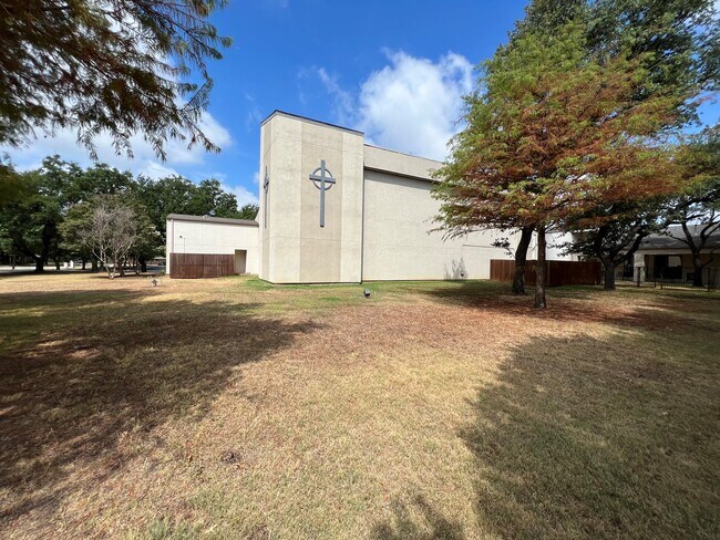
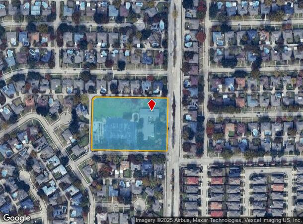
Property Record
2709 Custer Rd, Plano, TX 75075
Current Lease Availabilities
Property Detail
2709 Custer Rd
Dallas-Fort Worth-Arlington, TX
West Plano Presbyterian Church Addition
R-0533-000-0010-1
WEST PLANO PRESBYTERIAN CHURCH ADDITION, LOT 1
Religious
Collin
X
Texas
48085C0390K
1
0
3.99 AC
2025
Plano
031627
Dallas/Ft Worth
14,842 SF
NEARBY LISTINGS FOR SALE OR LEASE
DEMOGRAPHICS near 2709 Custer Rd
1 mile
3 mile
5 mile
2024 Total Population
15,381
135,399
350,218
2029 Population
18,594
164,329
417,568
Pop Growth 2024-2029
+ 20.89%
+ 21.37%
+ 19.23%
Average Age
43
40
40
2024 Total Households
5,954
53,390
137,689
HH Growth 2024-2029
+ 21.11%
+ 21.91%
+ 19.83%
Median Household Inc
$103,114
$86,811
$92,388
Avg Household Size
2.50
2.40
2.40
2024 Avg HH Vehicles
2.00
2.00
2.00
Median Home Value
$350,063
$348,171
$384,345
Median Year Built
1977
1985
1989
Nearby Places
Map Layers
Map Styles
 Street
 Aerial
Transit
 Traffic
 Biking
Places
Listings with unknown addresses are not visible on the map
- Restaurants
- Banks
- Shops
- Fitness
- Groceries
PUBLIC TRANSPORTATION
AIRPORT
Dallas Love Field
Drive
Walk
Distance
Dallas Love Field
31 min
22.6 mi
Dallas-Fort Worth International
Drive
Walk
Distance
Dallas-Fort Worth International
34 min
27.7 mi
Freight Ports
Port of Shreveport
Drive
Walk
Distance
Port of Shreveport
227 min
208.8 mi
Nearby Properties
Address
Land Use
TOTAL SIZE
Lot Size
Zoning
Address
Land Use
TOTAL SIZE
Lot Size
Zoning
1,049,441 SF
Address
Land Use
TOTAL SIZE
Lot Size
Zoning
1,283,376 SF
11.62 AC
Address
Land Use
TOTAL SIZE
Lot Size
Zoning
1,105,509 SF
92.46 AC
A
Address
Land Use
TOTAL SIZE
Lot Size
Zoning
659,402 SF
24.39 AC
O-M
Address
Land Use
TOTAL SIZE
Lot Size
Zoning
606,071 SF
64.75 AC
SFR
Address
Land Use
TOTAL SIZE
Lot Size
Zoning
369,694 SF
Address
Land Use
TOTAL SIZE
Lot Size
Zoning
384,538 SF
2.63 AC
LI-1
Address
Land Use
TOTAL SIZE
Lot Size
Zoning
341,492 SF
25.20 AC
SFR
Address
Land Use
TOTAL SIZE
Lot Size
Zoning
442,484 SF
APTS
Address
Land Use
TOTAL SIZE
Lot Size
Zoning
430,618 SF
11.33 AC
MF-H
Address
Land Use
TOTAL SIZE
Lot Size
Zoning
394,287 SF
14.96 AC
Address
Land Use
TOTAL SIZE
Lot Size
Zoning
507,693 SF
32.50 AC
MFL
Address
Land Use
TOTAL SIZE
Lot Size
Zoning
393,416 SF
Address
Land Use
TOTAL SIZE
Lot Size
Zoning
377,152 SF
3.91 AC
O-S
Address
Land Use
TOTAL SIZE
Lot Size
Zoning
451,672 SF
23.81 AC
LI-1
Address
Land Use
TOTAL SIZE
Lot Size
Zoning
509,566 SF
34.05 AC
PD
Address
Land Use
TOTAL SIZE
Lot Size
Zoning
289,093 SF
8.87 AC
R/O-2
Address
Land Use
TOTAL SIZE
Lot Size
Zoning
284,830 SF
2.98 AC
Address
Land Use
TOTAL SIZE
Lot Size
Zoning
386,448 SF
Address
Land Use
TOTAL SIZE
Lot Size
Zoning
324,000 SF
6.67 AC
O-S
Address
Land Use
TOTAL SIZE
Lot Size
Zoning
421,532 SF
4.29 AC
Address
Land Use
TOTAL SIZE
Lot Size
Zoning
445,959 SF
4.55 AC
MF-E
Address
Land Use
TOTAL SIZE
Lot Size
Zoning
64.94 AC
Address
Land Use
TOTAL SIZE
Lot Size
Zoning
460,233 SF
10.31 AC
CC
Address
Land Use
TOTAL SIZE
Lot Size
Zoning
408,256 SF
27.66 AC
MF-M
Address
Land Use
TOTAL SIZE
Lot Size
Zoning
417,173 SF
4.48 AC
O-S
Address
Land Use
TOTAL SIZE
Lot Size
Zoning
260,608 SF
18.68 AC
COMM
Address
Land Use
TOTAL SIZE
Lot Size
Zoning
211,607 SF
Address
Land Use
TOTAL SIZE
Lot Size
Zoning
457,656 SF
23.19 AC
MF-H
Address
Land Use
TOTAL SIZE
Lot Size
Zoning
262,695 SF
3.70 AC
The World's #1 Commercial Real Estate Marketplace
Connect with us
© 2026 CoStar Group
The information above has been obtained from sources believed reliable. While we do not doubt its accuracy we have not verified it and make no guarantee, warranty or representation about it. It is your responsibility to independently confirm its accuracy and completeness. Any projections, opinions, assumptions, or estimates used are for example only and do not represent the current or future performance of the property. The value of this transaction to you depends on tax and other factors which should be evaluated by your tax, financial, and legal advisors. You and your advisors should conduct a careful, independent investigation of the property to determine to your satisfaction the suitability of the property for your needs.