Property Record
271 C St, Washougal, WA 98671

NEARBY LISTINGS FOR SALE OR LEASE
Property Detail
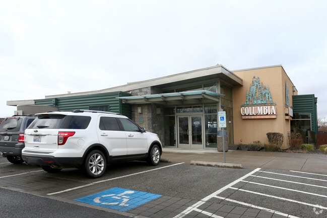
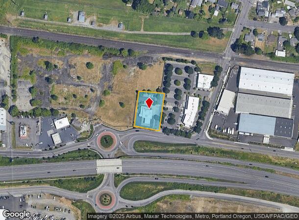
271 C St
073134-030
David Parker Dlc
Financialbuilding
#30 #190 DAVID C PARKER DLC .67A FOR ASSESSOR USE ONLY TT IN SEQ SEC 12-1-3E DAF: COMM AT SE COR OF SD SEQ TH N00- 46-07W ALG E LI OF SD SEQ 1277.79 FT TH S89-13-53W 1113.23 FT TO TPOB TH S83-34-12E 145.50 FT TH S06-25-48W 201 FT TO N LI OF C STREET
X
Clark
41051C0210J
Washington
2025
0.67 AC
2025
Camas/Washougal
041500
Portland
4,134 SF
Portland-Vancouver-Hillsboro, OR-WA
DEMOGRAPHICS near 271 C St
1 Mile
3 Mile
5 Mile
2024 Total Population
6,753
33,111
88,518
2029 Population
7,298
35,678
91,790
Pop Growth 2024-2029
+ 8.07%
+ 7.75%
+ 3.70%
Average Age
39
40
40
2024 Total Households
2,590
11,918
31,536
HH Growth 2024-2029
+ 8.15%
+ 7.84%
+ 3.57%
Median Household Inc
$81,384
$96,163
$91,886
Avg Household Size
2.60
2.80
2.80
2024 Avg HH Vehicles
2.00
2.00
2.00
Median Home Value
$544,304
$505,951
$468,552
Median Year Built
1993
1995
1993
Nearby Places
Map Layers
Map Styles
 Street
 Aerial
- Restaurants
- Banks
- Shops
- Fitness
- Groceries
PUBLIC TRANSPORTATION
AIRPORT
Portland International
DRIVE
WALK
Distance
Portland International
23 min
14.4 mi
Freight Ports
Port of Portland
DRIVE
WALK
Distance
Port of Portland
34 min
23.4 mi
Nearby Properties
Address
Land Use
TOTAL SIZE
Lot Size
Zoning
Address
Land Use
TOTAL SIZE
Lot Size
Zoning
1,500,000 SF
189.27 AC
HI
Address
Land Use
TOTAL SIZE
Lot Size
Zoning
Address
Land Use
TOTAL SIZE
Lot Size
Zoning
478,472 SF
77.86 AC
GI
Address
Land Use
TOTAL SIZE
Lot Size
Zoning
255,683 SF
32.06 AC
R-7.5
Address
Land Use
TOTAL SIZE
Lot Size
Zoning
857,470 SF
73.72 AC
GI
Address
Land Use
TOTAL SIZE
Lot Size
Zoning
262,320 SF
25.24 AC
IP
Address
Land Use
TOTAL SIZE
Lot Size
Zoning
14,059 SF
12.83 AC
GI
Address
Land Use
TOTAL SIZE
Lot Size
Zoning
224,500 SF
12.30 AC
R-7.5
Address
Land Use
TOTAL SIZE
Lot Size
Zoning
114,696 SF
2.29 AC
MF-18
Address
Land Use
TOTAL SIZE
Lot Size
Zoning
156,393 SF
5.82 AC
GC
Address
Land Use
TOTAL SIZE
Lot Size
Zoning
142,571 SF
1.73 AC
TC-C
Address
Land Use
TOTAL SIZE
Lot Size
Zoning
Address
Land Use
TOTAL SIZE
Lot Size
Zoning
349,080 SF
18.69 AC
GI
Address
Land Use
TOTAL SIZE
Lot Size
Zoning
65,604 SF
11.35 AC
R-7.5
Address
Land Use
TOTAL SIZE
Lot Size
Zoning
Address
Land Use
TOTAL SIZE
Lot Size
Zoning
4,490 SF
75.54 AC
GI
Address
Land Use
TOTAL SIZE
Lot Size
Zoning
85,150 SF
16.32 AC
R-7.5
Address
Land Use
TOTAL SIZE
Lot Size
Zoning
83,139 SF
7.36 AC
HI
Address
Land Use
TOTAL SIZE
Lot Size
Zoning
98,577 SF
7.28 AC
GI
Address
Land Use
TOTAL SIZE
Lot Size
Zoning
256,888 SF
18.91 AC
TC-C
Address
Land Use
TOTAL SIZE
Lot Size
Zoning
52,631 SF
3.04 AC
MF-10
Address
Land Use
TOTAL SIZE
Lot Size
Zoning
50,798 SF
19.17 AC
GC
Address
Land Use
TOTAL SIZE
Lot Size
Zoning
44.82 AC
SU
Address
Land Use
TOTAL SIZE
Lot Size
Zoning
108,108 SF
5.35 AC
IP
Address
Land Use
TOTAL SIZE
Lot Size
Zoning
64,400 SF
3.30 AC
MF-18
Address
Land Use
TOTAL SIZE
Lot Size
Zoning
10,000 SF
13.63 AC
R-7.5
Address
Land Use
TOTAL SIZE
Lot Size
Zoning
26,046 SF
1.75 AC
CBD
Address
Land Use
TOTAL SIZE
Lot Size
Zoning
75,360 SF
4.46 AC
RC
Address
Land Use
TOTAL SIZE
Lot Size
Zoning
51,600 SF
2.35 AC
AR-16
The World's #1 Commercial Real Estate Marketplace
Connect with us
© 2025 CoStar Group
The information above has been obtained from sources believed reliable. While we do not doubt its accuracy we have not verified it and make no guarantee, warranty or representation about it. It is your responsibility to independently confirm its accuracy and completeness. Any projections, opinions, assumptions, or estimates used are for example only and do not represent the current or future performance of the property. The value of this transaction to you depends on tax and other factors which should be evaluated by your tax, financial, and legal advisors. You and your advisors should conduct a careful, independent investigation of the property to determine to your satisfaction the suitability of the property for your needs.