No Photo
Property Record
271 Isaac Stevens Rd, Fleming, GA 31309

Save to a Folder
{{folder.Name}}
{{folder.ListingIds.length}} Properties
{{folder.ListingIds.length}} Property
Create a New Folder
Property Detail
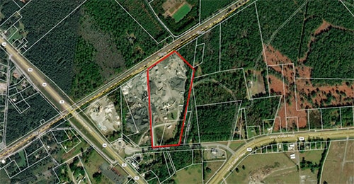
271 Isaac Stevens Rd
120-001
16.59 AC N/S ISSAC STEVENS RD
Industrialgeneral
LIBERTY
I1
Georgia
B and X Area of moderate flood hazard, usually the area between the limits of the 100-year and 500-year floods.
16.59 AC
2025
Liberty County
2025
Savannah
010504
Hinesville, GA
NEARBY LISTINGS FOR SALE OR LEASE
DEMOGRAPHICS near 271 Isaac Stevens Rd
1 mile
3 mile
5 mile
2025 Total Population
300
2,505
14,038
2030 Population
324
2,668
14,853
Pop Growth 2025-2030
+ 8.00%
+ 6.51%
+ 5.81%
Average Age
37
37
35
2025 Total Households
107
900
5,437
HH Growth 2025-2030
+ 8.41%
+ 6.67%
+ 6.03%
Median Household Inc
$74,999
$74,820
$62,857
Avg Household Size
2.80
2.80
2.50
2025 Avg HH Vehicles
2.00
2.00
2.00
Median Home Value
$267,499
$239,160
$218,188
Median Year Built
1996
1993
1990
Nearby Places
Map Layers
Map Styles
 Street
 Aerial
Layers
 Traffic
 Biking
Places
Listings with unknown addresses are not visible on the map
- Restaurants
- Banks
- Shops
- Fitness
- Groceries
PUBLIC TRANSPORTATION
AIRPORT
Savannah/Hilton Head International
Drive
Walk
Distance
Savannah/Hilton Head International
48 min
33.1 mi
Freight Ports
Georgia Ports - Savannah
Drive
Walk
Distance
Georgia Ports - Savannah
50 min
35.8 mi
SALE & LEASE HISTORY
LISTING DATE
SALE/LEASE

May 24, 2019
For Sale
Jul 26, 2019
For Sale
Nearby Properties
Address
Land Use
TOTAL SIZE
Lot Size
Zoning
Address
Land Use
TOTAL SIZE
Lot Size
Zoning
315,645 SF
57.37 AC
A1/R8
Address
Land Use
TOTAL SIZE
Lot Size
Zoning
20,424 SF
1.50 AC
AR1/C3
Address
Land Use
TOTAL SIZE
Lot Size
Zoning
4,599 SF
4 AC
AR1
Address
Land Use
TOTAL SIZE
Lot Size
Zoning
203.32 AC
PUD
Address
Land Use
TOTAL SIZE
Lot Size
Zoning
7.24 AC
PUD
Address
Land Use
TOTAL SIZE
Lot Size
Zoning
141.40 AC
R12
Address
Land Use
TOTAL SIZE
Lot Size
Zoning
12,000 SF
3.16 AC
C3
Address
Land Use
TOTAL SIZE
Lot Size
Zoning
126.02 AC
A1/AR1/R12
Address
Land Use
TOTAL SIZE
Lot Size
Zoning
9,217 SF
2 AC
C3
Address
Land Use
TOTAL SIZE
Lot Size
Zoning
318.47 AC
A1/AR1/R12
Address
Land Use
TOTAL SIZE
Lot Size
Zoning
3,111 SF
1.15 AC
C3
Address
Land Use
TOTAL SIZE
Lot Size
Zoning
4,320 SF
8.27 AC
A1/C3/R8
Address
Land Use
TOTAL SIZE
Lot Size
Zoning
60.19 AC
B2/I1
Address
Land Use
TOTAL SIZE
Lot Size
Zoning
457 AC
A1/R8
Address
Land Use
TOTAL SIZE
Lot Size
Zoning
4,421 SF
2.40 AC
C3
Address
Land Use
TOTAL SIZE
Lot Size
Zoning
4,474 SF
2 AC
C3
Address
Land Use
TOTAL SIZE
Lot Size
Zoning
15,000 SF
7.71 AC
C2
Address
Land Use
TOTAL SIZE
Lot Size
Zoning
17,358 SF
2.90 AC
C3
Address
Land Use
TOTAL SIZE
Lot Size
Zoning
550.84 AC
A1
Address
Land Use
TOTAL SIZE
Lot Size
Zoning
2,810 SF
6.22 AC
AR1
Address
Land Use
TOTAL SIZE
Lot Size
Zoning
502.14 AC
A1
Address
Land Use
TOTAL SIZE
Lot Size
Zoning
2,812 SF
1.22 AC
AR1
Address
Land Use
TOTAL SIZE
Lot Size
Zoning
231.10 AC
A1/AR1
Address
Land Use
TOTAL SIZE
Lot Size
Zoning
357 AC
A1
Address
Land Use
TOTAL SIZE
Lot Size
Zoning
3,843 SF
3 AC
C2
Address
Land Use
TOTAL SIZE
Lot Size
Zoning
430.66 AC
A1/AR1
Address
Land Use
TOTAL SIZE
Lot Size
Zoning
26.24 AC
C3/R8
Address
Land Use
TOTAL SIZE
Lot Size
Zoning
8,610 SF
1.45 AC
C3
Address
Land Use
TOTAL SIZE
Lot Size
Zoning
314.57 AC
A1
Address
Land Use
TOTAL SIZE
Lot Size
Zoning
3,510 SF
1.50 AC
AR1
The World's #1 Commercial Real Estate Marketplace
Connect with us
© 2026 CoStar Group
The information above has been obtained from sources believed reliable. While we do not doubt its accuracy we have not verified it and make no guarantee, warranty or representation about it. It is your responsibility to independently confirm its accuracy and completeness. Any projections, opinions, assumptions, or estimates used are for example only and do not represent the current or future performance of the property. The value of this transaction to you depends on tax and other factors which should be evaluated by your tax, financial, and legal advisors. You and your advisors should conduct a careful, independent investigation of the property to determine to your satisfaction the suitability of the property for your needs.