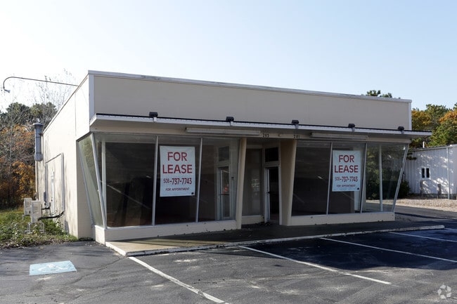
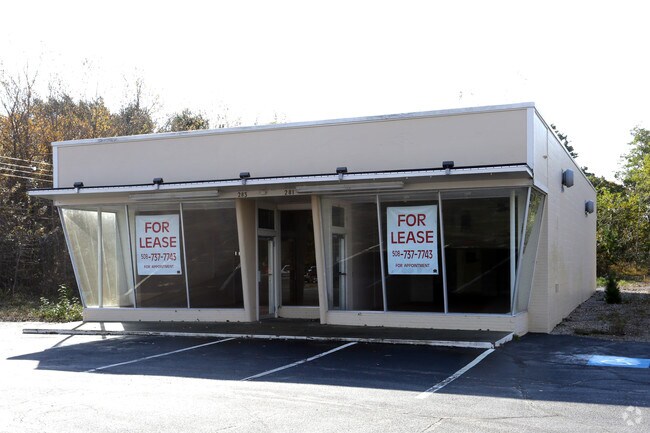
Property Record
271 Main St, South Dennis, MA 02660

Property Detail
271 Main St
DENN-000072-000000-000015
BARNSTABLE
Commercialnec
Massachusetts
AE The base floodplain where base flood elevations are provided. AE Zones are now used on new format FIRMs instead of A1-A30 Zones.
1.41 AC
2025
Cape Cod
2025
Other Market Areas
011500
Barnstable Town, MA
NEARBY LISTINGS FOR SALE OR LEASE
DEMOGRAPHICS near 271 Main St
1 mile
3 mile
5 mile
2025 Total Population
4,366
16,739
41,484
2030 Population
4,500
17,268
42,196
Pop Growth 2025-2030
+ 3.07%
+ 3.16%
+ 1.72%
Average Age
51
53
51
2025 Total Households
2,293
8,206
19,698
HH Growth 2025-2030
+ 2.97%
+ 3.24%
+ 1.71%
Median Household Inc
$64,022
$78,764
$83,763
Avg Household Size
1.90
2.00
2.00
2025 Avg HH Vehicles
2.00
2.00
2.00
Median Home Value
$525,430
$640,079
$599,439
Median Year Built
1965
1968
1971
Nearby Places
Map Layers
Map Styles
 Street
 Aerial
Layers
 Traffic
 Biking
Places
Listings with unknown addresses are not visible on the map
- Restaurants
- Banks
- Shops
- Fitness
- Groceries
PUBLIC TRANSPORTATION
COMMUTER RAIL
Hyannis (CapeFLYER - Cape Cod Regional Transit Authority)
Drive
Walk
Distance
Hyannis (CapeFLYER - Cape Cod Regional Transit Authority)
15 min
8.1 mi
AIRPORT
Nantucket Memorial
Drive
Walk
Distance
Nantucket Memorial
164 min
41.6 mi
Freight Ports
Port of New Bedford Harbor
Drive
Walk
Distance
Port of New Bedford Harbor
80 min
56.2 mi
Nearby Properties
Address
Land Use
TOTAL SIZE
Lot Size
Zoning
Address
Land Use
TOTAL SIZE
Lot Size
Zoning
138,804 SF
15.94 AC
Address
Land Use
TOTAL SIZE
Lot Size
Zoning
Address
Land Use
TOTAL SIZE
Lot Size
Zoning
3.42 AC
Address
Land Use
TOTAL SIZE
Lot Size
Zoning
10.34 AC
Address
Land Use
TOTAL SIZE
Lot Size
Zoning
Address
Land Use
TOTAL SIZE
Lot Size
Zoning
Address
Land Use
TOTAL SIZE
Lot Size
Zoning
14,844 SF
0.50 AC
Address
Land Use
TOTAL SIZE
Lot Size
Zoning
Address
Land Use
TOTAL SIZE
Lot Size
Zoning
Address
Land Use
TOTAL SIZE
Lot Size
Zoning
59,054 SF
9.53 AC
R
Address
Land Use
TOTAL SIZE
Lot Size
Zoning
11,017 SF
5.52 AC
Address
Land Use
TOTAL SIZE
Lot Size
Zoning
1,793 SF
1.32 AC
Address
Land Use
TOTAL SIZE
Lot Size
Zoning
7,172 SF
1.33 AC
Address
Land Use
TOTAL SIZE
Lot Size
Zoning
0.78 AC
R
Address
Land Use
TOTAL SIZE
Lot Size
Zoning
Address
Land Use
TOTAL SIZE
Lot Size
Zoning
6,276 SF
0.80 AC
R
Address
Land Use
TOTAL SIZE
Lot Size
Zoning
Address
Land Use
TOTAL SIZE
Lot Size
Zoning
0.80 AC
R
Address
Land Use
TOTAL SIZE
Lot Size
Zoning
9.77 AC
Address
Land Use
TOTAL SIZE
Lot Size
Zoning
2,942 SF
130.52 AC
Address
Land Use
TOTAL SIZE
Lot Size
Zoning
14.54 AC
Address
Land Use
TOTAL SIZE
Lot Size
Zoning
45.75 AC
R
Address
Land Use
TOTAL SIZE
Lot Size
Zoning
4,744 SF
0.44 AC
R
Address
Land Use
TOTAL SIZE
Lot Size
Zoning
38,518 SF
5.09 AC
Address
Land Use
TOTAL SIZE
Lot Size
Zoning
62,423 SF
13.98 AC
Address
Land Use
TOTAL SIZE
Lot Size
Zoning
0.66 AC
R
Address
Land Use
TOTAL SIZE
Lot Size
Zoning
3.17 AC
R
Address
Land Use
TOTAL SIZE
Lot Size
Zoning
0.51 AC
R
Address
Land Use
TOTAL SIZE
Lot Size
Zoning
0.74 AC
R
Address
Land Use
TOTAL SIZE
Lot Size
Zoning
0.98 AC
R
The World's #1 Commercial Real Estate Marketplace
Connect with us
© 2026 CoStar Group
The information above has been obtained from sources believed reliable. While we do not doubt its accuracy we have not verified it and make no guarantee, warranty or representation about it. It is your responsibility to independently confirm its accuracy and completeness. Any projections, opinions, assumptions, or estimates used are for example only and do not represent the current or future performance of the property. The value of this transaction to you depends on tax and other factors which should be evaluated by your tax, financial, and legal advisors. You and your advisors should conduct a careful, independent investigation of the property to determine to your satisfaction the suitability of the property for your needs.