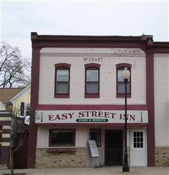
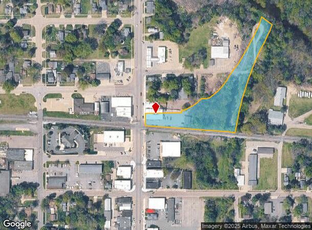
Property Record
271 N Paw Paw St, Coloma, MI 49038
NEARBY LISTINGS FOR SALE OR LEASE
-
-
View all Coloma listings for sale on LoopNet.com
Property Detail
271 N Paw Paw St
Niles-Benton Harbor, MI
Town Of Coloma
11-60-0340-0050-00-3
PRT OF LOTS 50 & 51 TOWN OF COLOMA BEG ON ELY R/W LN PAW PAW ST 78.5' S OF N LN SD LOT 50 TH S89DEG46'E 240' TO FORMER W R/W LN PMRR TH N59DEG03'E ON W R/W LN 151.58' TO N LN SD LOT 50 TH S8946'E 30' TH NELY TO ELY LN LOT 51 59' S00DEG14'W OF N LN SD
Storebuilding
Berrien
AE
Michigan
26159C0275D
50-51
2024
1.93 AC
2025
Michigan Southwest Area
010201
Other Market Areas
4,840 SF
DEMOGRAPHICS near 271 N Paw Paw St
1 Mile
3 Mile
5 Mile
2024 Total Population
2,332
10,421
16,946
2029 Population
2,303
10,384
16,996
Pop Growth 2024-2029
(1.24%)
(0.36%)
+ 0.30%
Average Age
44
43
43
2024 Total Households
964
4,329
7,006
HH Growth 2024-2029
(1.45%)
(0.35%)
+ 0.31%
Median Household Inc
$51,667
$54,327
$54,513
Avg Household Size
2.30
2.30
2.30
2024 Avg HH Vehicles
2.00
2.00
2.00
Median Home Value
$160,714
$152,029
$161,164
Median Year Built
1960
1969
1970
Nearby Places
Map Layers
Map Styles
 Street
 Aerial
- Restaurants
- Banks
- Shops
- Fitness
- Groceries
PUBLIC TRANSPORTATION
AIRPORT
South Bend International
DRIVE
WALK
Distance
South Bend International
56 min
41.4 mi
SALE & LEASE HISTORY
LISTING DATE
SALE/LEASE

Sep 23, 2016
For Sale
Mar 21, 2019
For Sale
Apr 10, 2018
For Sale
Nearby Properties
Address
Land Use
TOTAL SIZE
Lot Size
Zoning
Address
Land Use
TOTAL SIZE
Lot Size
Zoning
404,592 SF
41.62 AC
I IND
Address
Land Use
TOTAL SIZE
Lot Size
Zoning
101,349 SF
R1 S/F/LMB
Address
Land Use
TOTAL SIZE
Lot Size
Zoning
28.80 AC
Address
Land Use
TOTAL SIZE
Lot Size
Zoning
95,940 SF
AG-P
Address
Land Use
TOTAL SIZE
Lot Size
Zoning
3.37 AC
C
Address
Land Use
TOTAL SIZE
Lot Size
Zoning
Address
Land Use
TOTAL SIZE
Lot Size
Zoning
74.04 AC
Address
Land Use
TOTAL SIZE
Lot Size
Zoning
214,600 SF
23 AC
Address
Land Use
TOTAL SIZE
Lot Size
Zoning
4,160 SF
75.75 AC
RMH
Address
Land Use
TOTAL SIZE
Lot Size
Zoning
22,017 SF
3 AC
C-1
Address
Land Use
TOTAL SIZE
Lot Size
Zoning
Address
Land Use
TOTAL SIZE
Lot Size
Zoning
36,946 SF
10.20 AC
C-1
Address
Land Use
TOTAL SIZE
Lot Size
Zoning
69,000 SF
R-1A
Address
Land Use
TOTAL SIZE
Lot Size
Zoning
6,562 SF
5 AC
Address
Land Use
TOTAL SIZE
Lot Size
Zoning
94,750 SF
17.36 AC
AG-P
Address
Land Use
TOTAL SIZE
Lot Size
Zoning
56,600 SF
5.67 AC
C-1
Address
Land Use
TOTAL SIZE
Lot Size
Zoning
25.92 AC
AG
Address
Land Use
TOTAL SIZE
Lot Size
Zoning
23.02 AC
RMH
Address
Land Use
TOTAL SIZE
Lot Size
Zoning
31,645 SF
16 AC
I IND
Address
Land Use
TOTAL SIZE
Lot Size
Zoning
13,440 SF
4.12 AC
C-1
Address
Land Use
TOTAL SIZE
Lot Size
Zoning
4 AC
C
Address
Land Use
TOTAL SIZE
Lot Size
Zoning
11,223 SF
1.92 AC
C-1
Address
Land Use
TOTAL SIZE
Lot Size
Zoning
1.50 AC
Address
Land Use
TOTAL SIZE
Lot Size
Zoning
Address
Land Use
TOTAL SIZE
Lot Size
Zoning
6,740 SF
14.21 AC
RMH
Address
Land Use
TOTAL SIZE
Lot Size
Zoning
3,400 SF
1 AC
Address
Land Use
TOTAL SIZE
Lot Size
Zoning
53,190 SF
37.31 AC
I IND
Address
Land Use
TOTAL SIZE
Lot Size
Zoning
15.33 AC
RMH
Address
Land Use
TOTAL SIZE
Lot Size
Zoning
153.75 AC
L-1
Address
Land Use
TOTAL SIZE
Lot Size
Zoning
63,360 SF
3.34 AC
M-2
The World's #1 Commercial Real Estate Marketplace
Connect with us
© 2025 CoStar Group
The information above has been obtained from sources believed reliable. While we do not doubt its accuracy we have not verified it and make no guarantee, warranty or representation about it. It is your responsibility to independently confirm its accuracy and completeness. Any projections, opinions, assumptions, or estimates used are for example only and do not represent the current or future performance of the property. The value of this transaction to you depends on tax and other factors which should be evaluated by your tax, financial, and legal advisors. You and your advisors should conduct a careful, independent investigation of the property to determine to your satisfaction the suitability of the property for your needs.