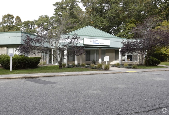
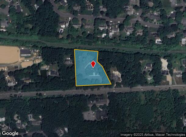
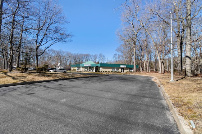
Property Record
Route 25A, Wading River, NY 11792
Current Lease Availabilities
NEARBY LISTINGS FOR SALE OR LEASE
Property Detail
Route 25A
Nassau County-Suffolk County, NY
Highway Estates
0200-128-00-01-00-011-012
HIGHWAY ESTATES 8321 5 & 6
Commercialbuilding
Suffolk
X
New York
36103C0428H
11
2024
2.74 AC
2024
Eastern Suffolk
169701
Long Island (New York)
DEMOGRAPHICS near Route 25A
1 Mile
3 Mile
5 Mile
2024 Total Population
2,782
22,234
39,727
2029 Population
2,760
22,134
39,548
Pop Growth 2024-2029
(0.79%)
(0.45%)
(0.45%)
Average Age
43
46
44
2024 Total Households
946
8,627
15,261
HH Growth 2024-2029
(0.95%)
(0.38%)
(0.43%)
Median Household Inc
$140,561
$108,770
$99,824
Avg Household Size
2.80
2.50
2.50
2024 Avg HH Vehicles
2.00
2.00
2.00
Median Home Value
$606,194
$448,105
$410,948
Median Year Built
1976
1977
1975
Nearby Places
Map Layers
Map Styles
 Street
 Aerial
- Restaurants
- Banks
- Shops
- Fitness
- Groceries
PUBLIC TRANSPORTATION
AIRPORT
Long Island MacArthur
DRIVE
WALK
Distance
Long Island MacArthur
37 min
22.8 mi
Nearby Properties
Address
Land Use
TOTAL SIZE
Lot Size
Zoning
Address
Land Use
TOTAL SIZE
Lot Size
Zoning
Address
Land Use
TOTAL SIZE
Lot Size
Zoning
41,075 SF
101 AC
02
Address
Land Use
TOTAL SIZE
Lot Size
Zoning
738.20 AC
02
Address
Land Use
TOTAL SIZE
Lot Size
Zoning
15.70 AC
Address
Land Use
TOTAL SIZE
Lot Size
Zoning
42 AC
PRP
Address
Land Use
TOTAL SIZE
Lot Size
Zoning
13.42 AC
02
Address
Land Use
TOTAL SIZE
Lot Size
Zoning
286.40 AC
4
Address
Land Use
TOTAL SIZE
Lot Size
Zoning
2,842 SF
0.21 AC
VILLA
Address
Land Use
TOTAL SIZE
Lot Size
Zoning
107,000 SF
11.40 AC
9
Address
Land Use
TOTAL SIZE
Lot Size
Zoning
17.70 AC
Address
Land Use
TOTAL SIZE
Lot Size
Zoning
1.14 AC
CR80
Address
Land Use
TOTAL SIZE
Lot Size
Zoning
2.50 AC
CR80
Address
Land Use
TOTAL SIZE
Lot Size
Zoning
593 SF
21.29 AC
02
Address
Land Use
TOTAL SIZE
Lot Size
Zoning
63,631 SF
14.38 AC
02
Address
Land Use
TOTAL SIZE
Lot Size
Zoning
864 SF
6.49 AC
02
Address
Land Use
TOTAL SIZE
Lot Size
Zoning
3,736 SF
1.14 AC
R2
Address
Land Use
TOTAL SIZE
Lot Size
Zoning
265 AC
NRP
Address
Land Use
TOTAL SIZE
Lot Size
Zoning
3,980 SF
191.40 AC
02
Address
Land Use
TOTAL SIZE
Lot Size
Zoning
21,775 SF
2.20 AC
2
Address
Land Use
TOTAL SIZE
Lot Size
Zoning
Address
Land Use
TOTAL SIZE
Lot Size
Zoning
4.14 AC
MRP
Address
Land Use
TOTAL SIZE
Lot Size
Zoning
26,740 SF
3.90 AC
2
Address
Land Use
TOTAL SIZE
Lot Size
Zoning
420 SF
6.70 AC
02
Address
Land Use
TOTAL SIZE
Lot Size
Zoning
7,219 SF
4.70 AC
OSC
Address
Land Use
TOTAL SIZE
Lot Size
Zoning
21,144 SF
6.30 AC
02
Address
Land Use
TOTAL SIZE
Lot Size
Zoning
12,000 SF
132.44 AC
Address
Land Use
TOTAL SIZE
Lot Size
Zoning
1,218 SF
0.81 AC
02
Address
Land Use
TOTAL SIZE
Lot Size
Zoning
1,632 SF
102.50 AC
09
Address
Land Use
TOTAL SIZE
Lot Size
Zoning
3.60 AC
Address
Land Use
TOTAL SIZE
Lot Size
Zoning
56.60 AC
RB80
The World's #1 Commercial Real Estate Marketplace
Connect with us
© 2026 CoStar Group
The information above has been obtained from sources believed reliable. While we do not doubt its accuracy we have not verified it and make no guarantee, warranty or representation about it. It is your responsibility to independently confirm its accuracy and completeness. Any projections, opinions, assumptions, or estimates used are for example only and do not represent the current or future performance of the property. The value of this transaction to you depends on tax and other factors which should be evaluated by your tax, financial, and legal advisors. You and your advisors should conduct a careful, independent investigation of the property to determine to your satisfaction the suitability of the property for your needs.