Property Record
271 S Liberty St, Powell, OH 43065
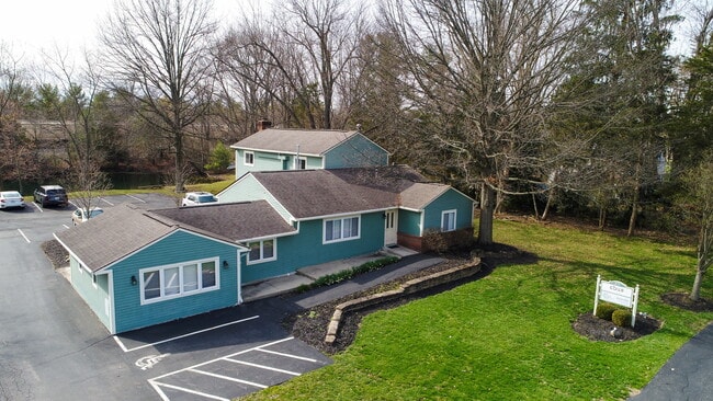


This Property Is For Sale
NEARBY LISTINGS FOR SALE OR LEASE
Property Detail
271 S Liberty St
Columbus, OH
Wedgewood Sec 07
319-431-02-029-000
LANDS 19 3 4 28 TIF AREA
Officebuilding
Delaware
X
Ohio
39041C0239K
28
2024
0.46 AC
2024
Outlying Delaware County
011421
Columbus
3,888 SF
DEMOGRAPHICS near 271 S Liberty St
1 Mile
3 Mile
5 Mile
2024 Total Population
8,480
61,532
174,907
2029 Population
9,601
65,720
185,405
Pop Growth 2024-2029
+ 13.22%
+ 6.81%
+ 6.00%
Average Age
41
39
38
2024 Total Households
3,048
22,412
66,621
HH Growth 2024-2029
+ 13.45%
+ 6.69%
+ 5.72%
Median Household Inc
$152,303
$130,071
$116,698
Avg Household Size
2.80
2.70
2.60
2024 Avg HH Vehicles
2.00
2.00
2.00
Median Home Value
$422,071
$404,068
$384,692
Median Year Built
1996
1991
1992
Nearby Places
Map Layers
Map Styles
 Street
 Aerial
- Restaurants
- Banks
- Shops
- Fitness
- Groceries
PUBLIC TRANSPORTATION
AIRPORT
John Glenn Columbus International
DRIVE
WALK
Distance
John Glenn Columbus International
31 min
20.7 mi
Rickenbacker International
DRIVE
WALK
Distance
Rickenbacker International
44 min
31.0 mi
Freight Ports
Port of Toledo
DRIVE
WALK
Distance
Port of Toledo
165 min
130.8 mi
Nearby Properties
Address
Land Use
TOTAL SIZE
Lot Size
Zoning
Address
Land Use
TOTAL SIZE
Lot Size
Zoning
90.16 AC
Address
Land Use
TOTAL SIZE
Lot Size
Zoning
56,770 SF
22.62 AC
Address
Land Use
TOTAL SIZE
Lot Size
Zoning
232,579 SF
54.30 AC
Address
Land Use
TOTAL SIZE
Lot Size
Zoning
261,872 SF
53.89 AC
Address
Land Use
TOTAL SIZE
Lot Size
Zoning
247,368 SF
7.88 AC
Address
Land Use
TOTAL SIZE
Lot Size
Zoning
67,908 SF
32.65 AC
Address
Land Use
TOTAL SIZE
Lot Size
Zoning
162,728 SF
4.80 AC
Address
Land Use
TOTAL SIZE
Lot Size
Zoning
159,901 SF
19.97 AC
Address
Land Use
TOTAL SIZE
Lot Size
Zoning
128,522 SF
13.43 AC
Address
Land Use
TOTAL SIZE
Lot Size
Zoning
69.13 AC
Address
Land Use
TOTAL SIZE
Lot Size
Zoning
138,296 SF
21.07 AC
Address
Land Use
TOTAL SIZE
Lot Size
Zoning
151,623 SF
27.47 AC
Address
Land Use
TOTAL SIZE
Lot Size
Zoning
148,499 SF
18.03 AC
Address
Land Use
TOTAL SIZE
Lot Size
Zoning
27,270 SF
18.55 AC
Address
Land Use
TOTAL SIZE
Lot Size
Zoning
1,203 SF
35.15 AC
Address
Land Use
TOTAL SIZE
Lot Size
Zoning
138,004 SF
19.99 AC
Address
Land Use
TOTAL SIZE
Lot Size
Zoning
21,184 SF
16.59 AC
Address
Land Use
TOTAL SIZE
Lot Size
Zoning
171,530 SF
13.28 AC
Address
Land Use
TOTAL SIZE
Lot Size
Zoning
136,123 SF
5.07 AC
Address
Land Use
TOTAL SIZE
Lot Size
Zoning
119,064 SF
1.86 AC
Address
Land Use
TOTAL SIZE
Lot Size
Zoning
96,797 SF
16.73 AC
Address
Land Use
TOTAL SIZE
Lot Size
Zoning
16,735 SF
10.40 AC
Address
Land Use
TOTAL SIZE
Lot Size
Zoning
6,676 SF
478.74 AC
Address
Land Use
TOTAL SIZE
Lot Size
Zoning
210,364 SF
34.55 AC
Address
Land Use
TOTAL SIZE
Lot Size
Zoning
103,836 SF
9.98 AC
Address
Land Use
TOTAL SIZE
Lot Size
Zoning
83,734 SF
20.24 AC
Address
Land Use
TOTAL SIZE
Lot Size
Zoning
112,516 SF
25.26 AC
Address
Land Use
TOTAL SIZE
Lot Size
Zoning
77,626 SF
17.62 AC
Address
Land Use
TOTAL SIZE
Lot Size
Zoning
57,750 SF
51.32 AC
Address
Land Use
TOTAL SIZE
Lot Size
Zoning
16,160 SF
9.21 AC
The World's #1 Commercial Real Estate Marketplace
Connect with us
© 2025 CoStar Group
The information above has been obtained from sources believed reliable. While we do not doubt its accuracy we have not verified it and make no guarantee, warranty or representation about it. It is your responsibility to independently confirm its accuracy and completeness. Any projections, opinions, assumptions, or estimates used are for example only and do not represent the current or future performance of the property. The value of this transaction to you depends on tax and other factors which should be evaluated by your tax, financial, and legal advisors. You and your advisors should conduct a careful, independent investigation of the property to determine to your satisfaction the suitability of the property for your needs.