Property Record
2710 Shaver St, Pasadena, TX 77502
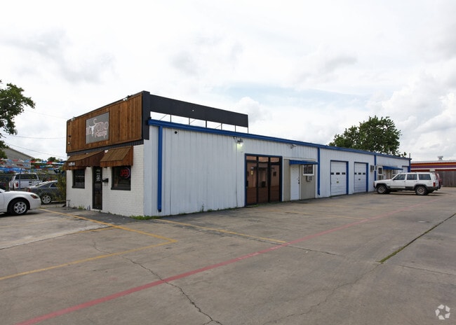

This Property Is For Sale
Property Detail
2710 Shaver St
0610860000030
TR 30C ALTA VISTA ACRES
Warehouse
HARRIS
C and X Area of minimal flood hazard, usually depicted on FIRMs as above the 500-year flood level.
Texas
2024
0.36 AC
2025
East-Southeast Far
321600
Houston
5,600 SF
Houston-Pasadena-The Woodlands, TX
NEARBY LISTINGS FOR SALE OR LEASE
DEMOGRAPHICS near 2710 Shaver St
1 mile
3 mile
5 mile
2025 Total Population
23,059
167,633
321,197
2030 Population
24,550
178,858
343,141
Pop Growth 2025-2030
+ 6.47%
+ 6.70%
+ 6.83%
Average Age
34
35
36
2025 Total Households
6,945
53,557
105,821
HH Growth 2025-2030
+ 6.68%
+ 6.92%
+ 7.06%
Median Household Inc
$56,396
$54,488
$58,447
Avg Household Size
3.20
3.10
3.00
2025 Avg HH Vehicles
2.00
2.00
2.00
Median Home Value
$183,484
$186,530
$206,068
Median Year Built
1966
1971
1974
Nearby Places
Map Layers
Map Styles
 Street
 Aerial
Layers
 Traffic
 Biking
Places
Listings with unknown addresses are not visible on the map
- Restaurants
- Banks
- Shops
- Fitness
- Groceries
PUBLIC TRANSPORTATION
AIRPORT
William P Hobby
Drive
Walk
Distance
William P Hobby
18 min
7.3 mi
George Bush Intcntl/Houston
Drive
Walk
Distance
George Bush Intcntl/Houston
42 min
30.1 mi
Freight Ports
Port of Houston
Drive
Walk
Distance
Port of Houston
18 min
8.5 mi
Nearby Properties
Address
Land Use
TOTAL SIZE
Lot Size
Zoning
Address
Land Use
TOTAL SIZE
Lot Size
Zoning
552,961 SF
25.01 AC
Address
Land Use
TOTAL SIZE
Lot Size
Zoning
345,420 SF
4.02 AC
Address
Land Use
TOTAL SIZE
Lot Size
Zoning
690,590 SF
31.88 AC
Address
Land Use
TOTAL SIZE
Lot Size
Zoning
414,017 SF
19.28 AC
Address
Land Use
TOTAL SIZE
Lot Size
Zoning
218,787 SF
10 AC
Address
Land Use
TOTAL SIZE
Lot Size
Zoning
411,252 SF
18.28 AC
Address
Land Use
TOTAL SIZE
Lot Size
Zoning
281,470 SF
11.24 AC
Address
Land Use
TOTAL SIZE
Lot Size
Zoning
397,739 SF
15.93 AC
Address
Land Use
TOTAL SIZE
Lot Size
Zoning
504,938 SF
28.96 AC
Address
Land Use
TOTAL SIZE
Lot Size
Zoning
363,740 SF
16.92 AC
Address
Land Use
TOTAL SIZE
Lot Size
Zoning
342,149 SF
23.56 AC
Address
Land Use
TOTAL SIZE
Lot Size
Zoning
188,111 SF
31.13 AC
Address
Land Use
TOTAL SIZE
Lot Size
Zoning
563,016 SF
19.84 AC
Address
Land Use
TOTAL SIZE
Lot Size
Zoning
538,431 SF
21.31 AC
Address
Land Use
TOTAL SIZE
Lot Size
Zoning
157,845 SF
12.52 AC
Address
Land Use
TOTAL SIZE
Lot Size
Zoning
230,218 SF
10.67 AC
Address
Land Use
TOTAL SIZE
Lot Size
Zoning
219,143 SF
10.84 AC
Address
Land Use
TOTAL SIZE
Lot Size
Zoning
260,972 SF
23.45 AC
Address
Land Use
TOTAL SIZE
Lot Size
Zoning
321,268 SF
9.59 AC
Address
Land Use
TOTAL SIZE
Lot Size
Zoning
Address
Land Use
TOTAL SIZE
Lot Size
Zoning
446,728 SF
16.69 AC
Address
Land Use
TOTAL SIZE
Lot Size
Zoning
308,748 SF
11.34 AC
Address
Land Use
TOTAL SIZE
Lot Size
Zoning
155,316 SF
4.26 AC
Address
Land Use
TOTAL SIZE
Lot Size
Zoning
171,935 SF
11.83 AC
Address
Land Use
TOTAL SIZE
Lot Size
Zoning
132,777 SF
14.33 AC
Address
Land Use
TOTAL SIZE
Lot Size
Zoning
166,883 SF
7.71 AC
Address
Land Use
TOTAL SIZE
Lot Size
Zoning
178,312 SF
5.55 AC
Address
Land Use
TOTAL SIZE
Lot Size
Zoning
163,919 SF
5.99 AC
Address
Land Use
TOTAL SIZE
Lot Size
Zoning
225,304 SF
9.93 AC
Address
Land Use
TOTAL SIZE
Lot Size
Zoning
207,056 SF
15.79 AC
The World's #1 Commercial Real Estate Marketplace
Connect with us
© 2026 CoStar Group
The information above has been obtained from sources believed reliable. While we do not doubt its accuracy we have not verified it and make no guarantee, warranty or representation about it. It is your responsibility to independently confirm its accuracy and completeness. Any projections, opinions, assumptions, or estimates used are for example only and do not represent the current or future performance of the property. The value of this transaction to you depends on tax and other factors which should be evaluated by your tax, financial, and legal advisors. You and your advisors should conduct a careful, independent investigation of the property to determine to your satisfaction the suitability of the property for your needs.