Property Record
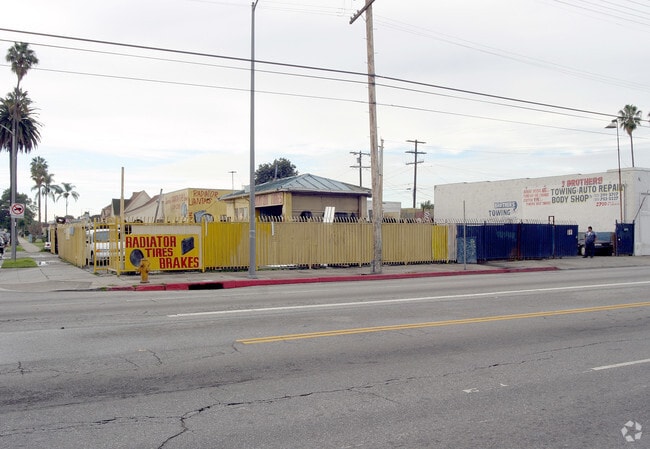
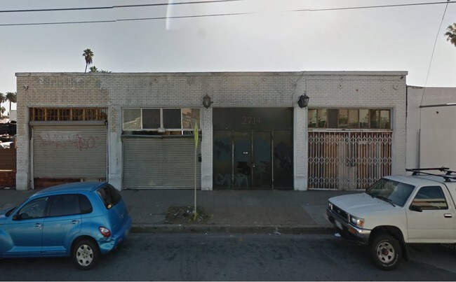
2704 W Slauson Ave, Los Angeles, CA 90043
NEARBY LISTINGS FOR SALE OR LEASE
Property Detail
2704 W Slauson Ave
Los Angeles-Long Beach-Glendale, CA
4515
4005-017-031
TR=4515 E 30 FT EX OF ST OF LOT 2 AND W 30 FT EX OF ST OF LOT 3 BLK 4
Autorepair
Los Angeles
X
California
06037C1777G
2,3
2024
0.21 AC
2025
Inglewood/South LA
234700
Los Angeles
1,209 SF
DEMOGRAPHICS near 2704 W Slauson Ave
1 Mile
3 Mile
5 Mile
2024 Total Population
41,911
372,974
1,049,392
2029 Population
40,689
359,887
1,012,917
Pop Growth 2024-2029
(2.92%)
(3.51%)
(3.48%)
Average Age
39
39
37
2024 Total Households
13,503
122,332
334,893
HH Growth 2024-2029
(3.13%)
(3.65%)
(3.50%)
Median Household Inc
$48,083
$55,661
$56,368
Avg Household Size
2.90
2.90
3.00
2024 Avg HH Vehicles
2.00
2.00
2.00
Median Home Value
$684,223
$720,297
$754,024
Median Year Built
1948
1949
1953
Nearby Places
Map Layers
Map Styles
 Street
 Aerial
- Restaurants
- Banks
- Shops
- Fitness
- Groceries
PUBLIC TRANSPORTATION
COMMUTER RAIL
DRIVE
WALK
Distance
16 min
9.3 mi
Union Station (91 Line - Southern California Regional Rail Authority (Metrolink), Antelope Valley Line - Southern California Regional Rail Authority (Metrolink), Orange County Line - Southern California Regional Rail Authority (Metrolink), Riverside Line - Southern California Regional Rail Authority (Metrolink), San Bernardino Line - Southern California Regional Rail Authority (Metrolink), Ventura County Line - Southern California Regional Rail Authority (Metrolink))
DRIVE
WALK
Distance
Union Station (91 Line - Southern California Regional Rail Authority (Metrolink), Antelope Valley Line - Southern California Regional Rail Authority (Metrolink), Orange County Line - Southern California Regional Rail Authority (Metrolink), Riverside Line - Southern California Regional Rail Authority (Metrolink), San Bernardino Line - Southern California Regional Rail Authority (Metrolink), Ventura County Line - Southern California Regional Rail Authority (Metrolink))
18 min
9.5 mi
AIRPORT
Los Angeles International
DRIVE
WALK
Distance
Los Angeles International
15 min
7.2 mi
Long Beach (Daugherty Field)
DRIVE
WALK
Distance
Long Beach (Daugherty Field)
30 min
20.2 mi
Bob Hope
DRIVE
WALK
Distance
Bob Hope
36 min
24.4 mi
Freight Ports
Port of Long Beach
DRIVE
WALK
Distance
Port of Long Beach
34 min
22.2 mi
SALE & LEASE HISTORY
LISTING DATE
SALE/LEASE

Oct 30, 2017
For Lease
Nearby Properties
Address
Land Use
TOTAL SIZE
Lot Size
Zoning
Address
Land Use
TOTAL SIZE
Lot Size
Zoning
2,531,696 SF
79.60 AC
INCR*
Address
Land Use
TOTAL SIZE
Lot Size
Zoning
256,059 SF
Address
Land Use
TOTAL SIZE
Lot Size
Zoning
337,025 SF
14.59 AC
LAUSC-1A
Address
Land Use
TOTAL SIZE
Lot Size
Zoning
724,715 SF
5.76 AC
INCR*
Address
Land Use
TOTAL SIZE
Lot Size
Zoning
377,946 SF
5.03 AC
LAUSC-1A
Address
Land Use
TOTAL SIZE
Lot Size
Zoning
1,359,630 SF
29 AC
INCR*
Address
Land Use
TOTAL SIZE
Lot Size
Zoning
102,877 SF
8.69 AC
LAC2
Address
Land Use
TOTAL SIZE
Lot Size
Zoning
343,879 SF
4.26 AC
LAC2
Address
Land Use
TOTAL SIZE
Lot Size
Zoning
181,213 SF
3.96 AC
INCR*
Address
Land Use
TOTAL SIZE
Lot Size
Zoning
188,146 SF
1.54 AC
LAUSC-1A
Address
Land Use
TOTAL SIZE
Lot Size
Zoning
377,831 SF
8.17 AC
LCC4*
Address
Land Use
TOTAL SIZE
Lot Size
Zoning
116,827 SF
0.64 AC
LAC2
Address
Land Use
TOTAL SIZE
Lot Size
Zoning
376,135 SF
8.02 AC
LCC4*
Address
Land Use
TOTAL SIZE
Lot Size
Zoning
144,111 SF
6.94 AC
INM1*
Address
Land Use
TOTAL SIZE
Lot Size
Zoning
102,789 SF
0.86 AC
INR3*
Address
Land Use
TOTAL SIZE
Lot Size
Zoning
57,488 SF
4.30 AC
LAPF
Address
Land Use
TOTAL SIZE
Lot Size
Zoning
0.35 AC
INC1*
Address
Land Use
TOTAL SIZE
Lot Size
Zoning
220,083 SF
4.95 AC
LAR3
Address
Land Use
TOTAL SIZE
Lot Size
Zoning
185,343 SF
1.27 AC
LAC1.5
Address
Land Use
TOTAL SIZE
Lot Size
Zoning
233,461 SF
5.48 AC
1NM1*
Address
Land Use
TOTAL SIZE
Lot Size
Zoning
134,044 SF
1.90 AC
LAC2
Address
Land Use
TOTAL SIZE
Lot Size
Zoning
286,496 SF
9.60 AC
LAC2
Address
Land Use
TOTAL SIZE
Lot Size
Zoning
729,505 SF
8.74 AC
LAUSC-1A
Address
Land Use
TOTAL SIZE
Lot Size
Zoning
172,452 SF
3.31 AC
INR4*
Address
Land Use
TOTAL SIZE
Lot Size
Zoning
193,748 SF
6.91 AC
LAC2
Address
Land Use
TOTAL SIZE
Lot Size
Zoning
212,699 SF
7.11 AC
LAC2
Address
Land Use
TOTAL SIZE
Lot Size
Zoning
81,735 SF
4.10 AC
LAR4
Address
Land Use
TOTAL SIZE
Lot Size
Zoning
267,463 SF
INCR
Address
Land Use
TOTAL SIZE
Lot Size
Zoning
203,718 SF
8.74 AC
INM1*
The World's #1 Commercial Real Estate Marketplace
Connect with us
© 2026 CoStar Group
The information above has been obtained from sources believed reliable. While we do not doubt its accuracy we have not verified it and make no guarantee, warranty or representation about it. It is your responsibility to independently confirm its accuracy and completeness. Any projections, opinions, assumptions, or estimates used are for example only and do not represent the current or future performance of the property. The value of this transaction to you depends on tax and other factors which should be evaluated by your tax, financial, and legal advisors. You and your advisors should conduct a careful, independent investigation of the property to determine to your satisfaction the suitability of the property for your needs.