Property Record
2711 Sw 58Th Ave, Amarillo, TX 79118

Property Detail
2711 Sw 58Th Ave
R-073-1810-9550-0
SOUTH SIDE ACRES # 24, BLK 0003, ALL OF 12A AND 13A, 7.2100 ACRES
Supermarket
Randall
B and X Area of moderate flood hazard, usually the area between the limits of the 100-year and 500-year floods.
Texas
2024
7.22 AC
2025
Amarillo
022001
Other Market Areas
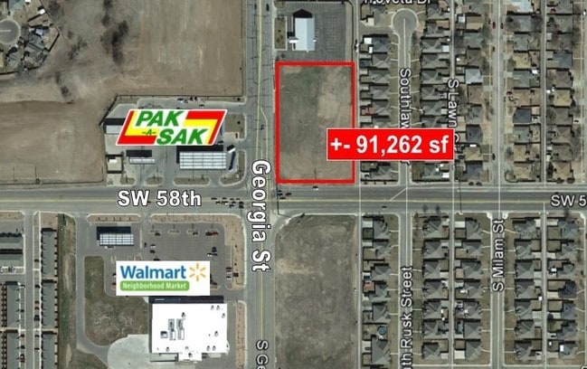
42,690 SF
Amarillo, TX
NEARBY LISTINGS FOR SALE OR LEASE
DEMOGRAPHICS near 2711 Sw 58Th Ave
1 mile
3 mile
5 mile
2025 Total Population
10,670
74,873
153,426
2030 Population
11,157
78,097
158,020
Pop Growth 2025-2030
+ 4.56%
+ 4.31%
+ 2.99%
Average Age
37
38
39
2025 Total Households
4,222
30,848
62,954
HH Growth 2025-2030
+ 4.76%
+ 4.25%
+ 2.93%
Median Household Inc
$74,302
$73,263
$67,812
Avg Household Size
2.40
2.40
2.40
2025 Avg HH Vehicles
2.00
2.00
2.00
Median Home Value
$164,949
$213,955
$217,241
Median Year Built
1984
1975
1975
Nearby Places
Map Layers
Map Styles
 Street
 Aerial
Layers
 Traffic
 Biking
Places
Listings with unknown addresses are not visible on the map
- Restaurants
- Banks
- Shops
- Fitness
- Groceries
PUBLIC TRANSPORTATION
AIRPORT
Rick Husband Amarillo International
Drive
Walk
Distance
Rick Husband Amarillo International
20 min
13.0 mi
Freight Ports
Tulsa Port Of Catoosa
Drive
Walk
Distance
Tulsa Port Of Catoosa
403 min
381.0 mi
SALE & LEASE HISTORY
LISTING DATE
SALE/LEASE

Sep 24, 2016
For Sale
Nearby Properties
Address
Land Use
TOTAL SIZE
Lot Size
Zoning
Address
Land Use
TOTAL SIZE
Lot Size
Zoning
362,796 SF
49.98 AC
A
Address
Land Use
TOTAL SIZE
Lot Size
Zoning
228,223 SF
20.83 AC
Address
Land Use
TOTAL SIZE
Lot Size
Zoning
431,320 SF
14.82 AC
1F2 S
Address
Land Use
TOTAL SIZE
Lot Size
Zoning
342,930 SF
34.57 AC
PD
Address
Land Use
TOTAL SIZE
Lot Size
Zoning
112,261 SF
21.82 AC
Address
Land Use
TOTAL SIZE
Lot Size
Zoning
168,978 SF
4.23 AC
1F2 S
Address
Land Use
TOTAL SIZE
Lot Size
Zoning
168,130 SF
16.32 AC
Address
Land Use
TOTAL SIZE
Lot Size
Zoning
182,242 SF
20.70 AC
Address
Land Use
TOTAL SIZE
Lot Size
Zoning
210,217 SF
10.49 AC
M11
Address
Land Use
TOTAL SIZE
Lot Size
Zoning
74,960 SF
7 AC
R2
Address
Land Use
TOTAL SIZE
Lot Size
Zoning
204,468 SF
17.56 AC
Address
Land Use
TOTAL SIZE
Lot Size
Zoning
161,321 SF
31 AC
A
Address
Land Use
TOTAL SIZE
Lot Size
Zoning
167,257 SF
12.66 AC
Address
Land Use
TOTAL SIZE
Lot Size
Zoning
161,221 SF
11.78 AC
MF1
Address
Land Use
TOTAL SIZE
Lot Size
Zoning
112,005 SF
7.70 AC
GR
Address
Land Use
TOTAL SIZE
Lot Size
Zoning
183,758 SF
16.74 AC
R2
Address
Land Use
TOTAL SIZE
Lot Size
Zoning
185,895 SF
9.59 AC
Address
Land Use
TOTAL SIZE
Lot Size
Zoning
172,531 SF
10.37 AC
LC
Address
Land Use
TOTAL SIZE
Lot Size
Zoning
297,246 SF
13.91 AC
MF1
Address
Land Use
TOTAL SIZE
Lot Size
Zoning
187,253 SF
9.69 AC
PD
Address
Land Use
TOTAL SIZE
Lot Size
Zoning
120,684 SF
18.94 AC
R2
Address
Land Use
TOTAL SIZE
Lot Size
Zoning
68,214 SF
9.06 AC
Address
Land Use
TOTAL SIZE
Lot Size
Zoning
131,544 SF
16.01 AC
R2
Address
Land Use
TOTAL SIZE
Lot Size
Zoning
155,721 SF
7.38 AC
GR
Address
Land Use
TOTAL SIZE
Lot Size
Zoning
217,018 SF
20.82 AC
LC
Address
Land Use
TOTAL SIZE
Lot Size
Zoning
94,851 SF
5.95 AC
R2
Address
Land Use
TOTAL SIZE
Lot Size
Zoning
92,058 SF
6.89 AC
PD
Address
Land Use
TOTAL SIZE
Lot Size
Zoning
135,251 SF
6.99 AC
MF1
Address
Land Use
TOTAL SIZE
Lot Size
Zoning
694,915 SF
27.22 AC
Address
Land Use
TOTAL SIZE
Lot Size
Zoning
70,253 SF
8.78 AC
A
The World's #1 Commercial Real Estate Marketplace
Connect with us
© 2026 CoStar Group
The information above has been obtained from sources believed reliable. While we do not doubt its accuracy we have not verified it and make no guarantee, warranty or representation about it. It is your responsibility to independently confirm its accuracy and completeness. Any projections, opinions, assumptions, or estimates used are for example only and do not represent the current or future performance of the property. The value of this transaction to you depends on tax and other factors which should be evaluated by your tax, financial, and legal advisors. You and your advisors should conduct a careful, independent investigation of the property to determine to your satisfaction the suitability of the property for your needs.