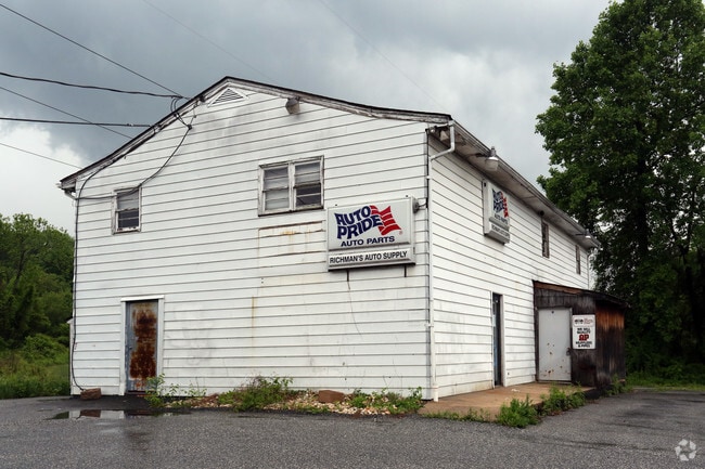
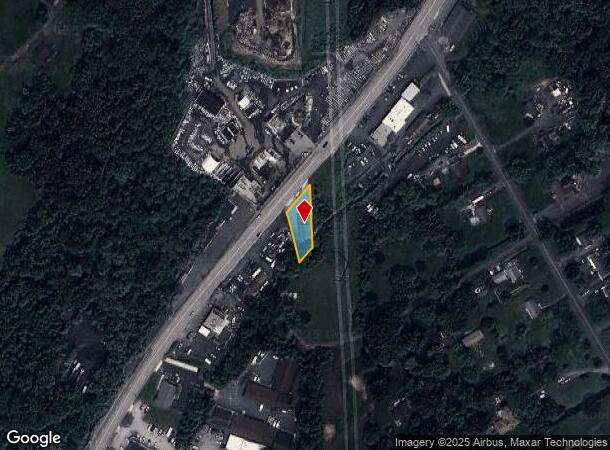
Property Record
2713 Bel Air Rd, Fallston, MD 21047

NEARBY LISTINGS FOR SALE OR LEASE
Property Detail
2713 Bel Air Rd
03-030679
LOT .245 AC 2713 BEL AIR ROAD NEAR LYNCH CORNER
Storebuilding
Harford
AE
Maryland
2400100285G
0.25 AC
2025
Outlying Harford County
2025
Baltimore
303400
Baltimore-Columbia-Towson, MD
3,600 SF
DEMOGRAPHICS near 2713 Bel Air Rd
1 Mile
3 Mile
5 Mile
2024 Total Population
2,245
13,929
77,035
2029 Population
2,318
14,171
78,687
Pop Growth 2024-2029
+ 3.25%
+ 1.74%
+ 2.14%
Average Age
45
45
42
2024 Total Households
824
5,190
29,193
HH Growth 2024-2029
+ 3.16%
+ 1.71%
+ 2.20%
Median Household Inc
$120,692
$120,048
$106,053
Avg Household Size
2.70
2.70
2.60
2024 Avg HH Vehicles
3.00
2.00
2.00
Median Home Value
$419,815
$428,765
$361,664
Median Year Built
1976
1974
1985
Nearby Places
Map Layers
Map Styles
 Street
 Aerial
- Restaurants
- Banks
- Shops
- Fitness
- Groceries
PUBLIC TRANSPORTATION
COMMUTER RAIL
Edgewood (Penn Line - Maryland Area Regional Commuter Trains (The MARC))
DRIVE
WALK
Distance
Edgewood (Penn Line - Maryland Area Regional Commuter Trains (The MARC))
16 min
9.2 mi
AIRPORT
Baltimore/Washington International Thurgood Marshall
DRIVE
WALK
Distance
Baltimore/Washington International Thurgood Marshall
49 min
34.2 mi
Freight Ports
Port of Baltimore
DRIVE
WALK
Distance
Port of Baltimore
38 min
27.7 mi
Nearby Properties
Address
Land Use
TOTAL SIZE
Lot Size
Zoning
Address
Land Use
TOTAL SIZE
Lot Size
Zoning
42,087 SF
17.21 AC
B3
Address
Land Use
TOTAL SIZE
Lot Size
Zoning
233,500 SF
96.38 AC
AG
Address
Land Use
TOTAL SIZE
Lot Size
Zoning
15,010 SF
19.12 AC
B3
Address
Land Use
TOTAL SIZE
Lot Size
Zoning
152,130 SF
21.10 AC
B2 B3
Address
Land Use
TOTAL SIZE
Lot Size
Zoning
2,520 SF
13.77 AC
B3
Address
Land Use
TOTAL SIZE
Lot Size
Zoning
14,412 SF
9.29 AC
B3
Address
Land Use
TOTAL SIZE
Lot Size
Zoning
16,129 SF
58.25 AC
AG
Address
Land Use
TOTAL SIZE
Lot Size
Zoning
6,889 SF
7.83 AC
B3
Address
Land Use
TOTAL SIZE
Lot Size
Zoning
10,384 SF
4.44 AC
B3
Address
Land Use
TOTAL SIZE
Lot Size
Zoning
26,104 SF
24.49 AC
CI
Address
Land Use
TOTAL SIZE
Lot Size
Zoning
53,500 SF
13 AC
RC5
Address
Land Use
TOTAL SIZE
Lot Size
Zoning
13,206 SF
1.81 AC
B3
Address
Land Use
TOTAL SIZE
Lot Size
Zoning
23,371 SF
7.52 AC
B3
Address
Land Use
TOTAL SIZE
Lot Size
Zoning
1,030 SF
5.36 AC
B3
Address
Land Use
TOTAL SIZE
Lot Size
Zoning
8,274 SF
262.80 AC
AG
Address
Land Use
TOTAL SIZE
Lot Size
Zoning
33,298 SF
4.75 AC
RC2
Address
Land Use
TOTAL SIZE
Lot Size
Zoning
83,576 SF
6.21 AC
B3
Address
Land Use
TOTAL SIZE
Lot Size
Zoning
8,636 SF
1.22 AC
B3
Address
Land Use
TOTAL SIZE
Lot Size
Zoning
10,394 SF
4.93 AC
B3 RR
Address
Land Use
TOTAL SIZE
Lot Size
Zoning
20,914 SF
25.21 AC
AG
Address
Land Use
TOTAL SIZE
Lot Size
Zoning
38,751 SF
10.51 AC
Address
Land Use
TOTAL SIZE
Lot Size
Zoning
32,800 SF
6.92 AC
B3
Address
Land Use
TOTAL SIZE
Lot Size
Zoning
6,400 SF
5.88 AC
CI
Address
Land Use
TOTAL SIZE
Lot Size
Zoning
20,849 SF
7.46 AC
Address
Land Use
TOTAL SIZE
Lot Size
Zoning
11,700 SF
4.97 AC
CI
Address
Land Use
TOTAL SIZE
Lot Size
Zoning
5,760 SF
2.19 AC
B3
Address
Land Use
TOTAL SIZE
Lot Size
Zoning
4,736 SF
1.98 AC
B3
Address
Land Use
TOTAL SIZE
Lot Size
Zoning
17,422 SF
1.35 AC
B3
Address
Land Use
TOTAL SIZE
Lot Size
Zoning
3,539 SF
0.75 AC
B3
Address
Land Use
TOTAL SIZE
Lot Size
Zoning
1,225 SF
4.26 AC
CI
The World's #1 Commercial Real Estate Marketplace
Connect with us
© 2026 CoStar Group
The information above has been obtained from sources believed reliable. While we do not doubt its accuracy we have not verified it and make no guarantee, warranty or representation about it. It is your responsibility to independently confirm its accuracy and completeness. Any projections, opinions, assumptions, or estimates used are for example only and do not represent the current or future performance of the property. The value of this transaction to you depends on tax and other factors which should be evaluated by your tax, financial, and legal advisors. You and your advisors should conduct a careful, independent investigation of the property to determine to your satisfaction the suitability of the property for your needs.