Property Record
2713 N Us Highway 27, Saint Johns, MI 48879

NEARBY LISTINGS FOR SALE OR LEASE
Property Detail
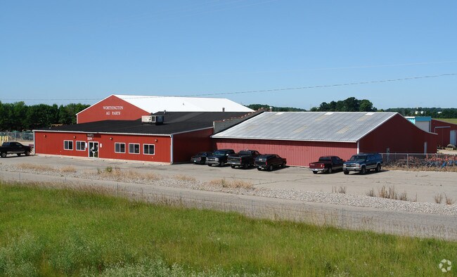
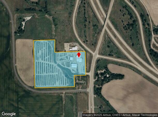
2713 N Us Highway 27
030-005-100-025-00
COM 836.36 FT S OF NE COR OF SEC 5 T7N R2W, TH S 521.8 FT, W 809.49 FT, N271.82 FT ALG C/L OF MOORE-PERRIN DRN, W 474.31 FT,
Storebuilding
Clinton
A
Michigan
26057C0450C
23.37 AC
0
Outlying Clinton County
2025
West Michigan
010901
Lansing-East Lansing, MI
4,956 SF
DEMOGRAPHICS near 2713 N Us Highway 27
1 Mile
3 Mile
5 Mile
2024 Total Population
485
9,164
12,614
2029 Population
496
9,358
12,850
Pop Growth 2024-2029
+ 2.27%
+ 2.12%
+ 1.87%
Average Age
42
41
42
2024 Total Households
193
3,840
5,145
HH Growth 2024-2029
+ 2.07%
+ 2.06%
+ 1.85%
Median Household Inc
$70,781
$74,203
$72,854
Avg Household Size
2.40
2.30
2.40
2024 Avg HH Vehicles
2.00
2.00
2.00
Median Home Value
$207,447
$175,588
$189,278
Median Year Built
1979
1966
1970
Nearby Places
Map Layers
Map Styles
 Street
 Aerial
- Restaurants
- Banks
- Shops
- Fitness
- Groceries
PUBLIC TRANSPORTATION
AIRPORT
Capital Region International
DRIVE
WALK
Distance
Capital Region International
32 min
25.8 mi
Nearby Properties
Address
Land Use
TOTAL SIZE
Lot Size
Zoning
Address
Land Use
TOTAL SIZE
Lot Size
Zoning
375,000 SF
Address
Land Use
TOTAL SIZE
Lot Size
Zoning
339,220 SF
36.58 AC
I-1
Address
Land Use
TOTAL SIZE
Lot Size
Zoning
106,182 SF
65 AC
Address
Land Use
TOTAL SIZE
Lot Size
Zoning
46,540 SF
13.78 AC
RO
Address
Land Use
TOTAL SIZE
Lot Size
Zoning
137,552 SF
16.85 AC
I-2
Address
Land Use
TOTAL SIZE
Lot Size
Zoning
75,000 SF
Address
Land Use
TOTAL SIZE
Lot Size
Zoning
163,881 SF
14.07 AC
I-1
Address
Land Use
TOTAL SIZE
Lot Size
Zoning
84.91 AC
AGR
Address
Land Use
TOTAL SIZE
Lot Size
Zoning
79,006 SF
31.12 AC
R3
Address
Land Use
TOTAL SIZE
Lot Size
Zoning
54,390 SF
22.62 AC
MC
Address
Land Use
TOTAL SIZE
Lot Size
Zoning
70,510 SF
9.33 AC
C-2
Address
Land Use
TOTAL SIZE
Lot Size
Zoning
69,347 SF
11.25 AC
GC
Address
Land Use
TOTAL SIZE
Lot Size
Zoning
6,208 SF
7.09 AC
R3
Address
Land Use
TOTAL SIZE
Lot Size
Zoning
13,300 SF
32.81 AC
A-2
Address
Land Use
TOTAL SIZE
Lot Size
Zoning
34,423 SF
2.92 AC
O
Address
Land Use
TOTAL SIZE
Lot Size
Zoning
17,141 SF
2.91 AC
I-1
Address
Land Use
TOTAL SIZE
Lot Size
Zoning
17,760 SF
3.59 AC
R3
Address
Land Use
TOTAL SIZE
Lot Size
Zoning
792 SF
14.48 AC
RMH
Address
Land Use
TOTAL SIZE
Lot Size
Zoning
17,760 SF
3.42 AC
R3
Address
Land Use
TOTAL SIZE
Lot Size
Zoning
54,154 SF
4.28 AC
I-1
Address
Land Use
TOTAL SIZE
Lot Size
Zoning
45,744 SF
Address
Land Use
TOTAL SIZE
Lot Size
Zoning
9,600 SF
12.88 AC
I-1
Address
Land Use
TOTAL SIZE
Lot Size
Zoning
43,496 SF
7.31 AC
I-1
Address
Land Use
TOTAL SIZE
Lot Size
Zoning
10,230 SF
2.64 AC
I-1
Address
Land Use
TOTAL SIZE
Lot Size
Zoning
6,048 SF
5.81 AC
R3
Address
Land Use
TOTAL SIZE
Lot Size
Zoning
26,248 SF
2.72 AC
I-1
Address
Land Use
TOTAL SIZE
Lot Size
Zoning
158.43 AC
AGR
Address
Land Use
TOTAL SIZE
Lot Size
Zoning
261.56 AC
A-2
Address
Land Use
TOTAL SIZE
Lot Size
Zoning
17,760 SF
3.36 AC
R3
Address
Land Use
TOTAL SIZE
Lot Size
Zoning
6,000 SF
29.30 AC
A-2
The World's #1 Commercial Real Estate Marketplace
Connect with us
© 2026 CoStar Group
The information above has been obtained from sources believed reliable. While we do not doubt its accuracy we have not verified it and make no guarantee, warranty or representation about it. It is your responsibility to independently confirm its accuracy and completeness. Any projections, opinions, assumptions, or estimates used are for example only and do not represent the current or future performance of the property. The value of this transaction to you depends on tax and other factors which should be evaluated by your tax, financial, and legal advisors. You and your advisors should conduct a careful, independent investigation of the property to determine to your satisfaction the suitability of the property for your needs.