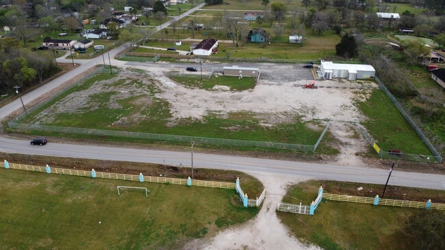
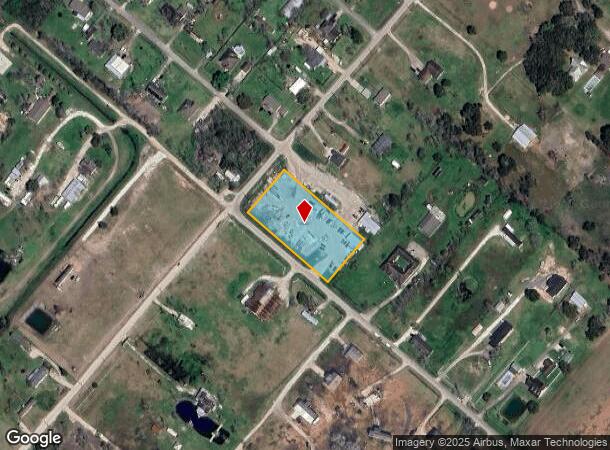
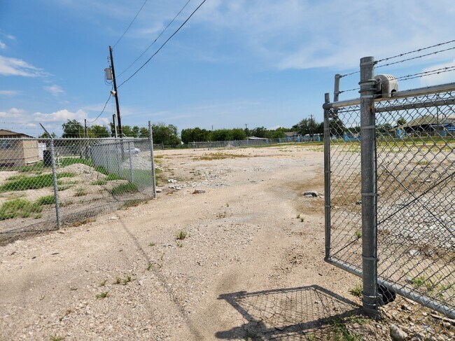
Property Record
181 County Road 181 & Cr 146, Alvin, TX 77511
Current Lease Availabilities
NEARBY LISTINGS FOR SALE OR LEASE
Property Detail
181 County Road 181 & Cr 146
Houston-The Woodlands-Sugar Land, TX
H T & B R R
0229-0011-006
A0229 H T & B R R, TRACT 35G, ACRES 2.000
Vacantlandnec
Brazoria
X
Texas
48039C0135K
2 AC
2024
South Hwy 35
2025
Houston
661400
DEMOGRAPHICS near 181 County Road 181 & Cr 146
1 Mile
3 Mile
5 Mile
2024 Total Population
1,796
13,028
47,484
2029 Population
2,016
14,582
53,172
Pop Growth 2024-2029
+ 12.25%
+ 11.93%
+ 11.98%
Average Age
39
39
38
2024 Total Households
588
4,359
16,600
HH Growth 2024-2029
+ 12.41%
+ 12.07%
+ 12.08%
Median Household Inc
$62,895
$71,845
$67,896
Avg Household Size
2.90
2.90
2.80
2024 Avg HH Vehicles
2.00
2.00
2.00
Median Home Value
$248,913
$225,926
$213,846
Median Year Built
1991
1988
1990
Nearby Places
- Restaurants
- Banks
- Shops
- Fitness
- Groceries
PUBLIC TRANSPORTATION
AIRPORT
William P Hobby
DRIVE
WALK
Distance
William P Hobby
37 min
20.3 mi
Freight Ports
Port of Houston
DRIVE
WALK
Distance
Port of Houston
47 min
31.6 mi
Nearby Properties
Address
Land Use
TOTAL SIZE
Lot Size
Zoning
Address
Land Use
TOTAL SIZE
Lot Size
Zoning
39.21 AC
0113
Address
Land Use
TOTAL SIZE
Lot Size
Zoning
172,015 SF
18.36 AC
Address
Land Use
TOTAL SIZE
Lot Size
Zoning
41,510 SF
20.52 AC
Address
Land Use
TOTAL SIZE
Lot Size
Zoning
111,370 SF
11.10 AC
Address
Land Use
TOTAL SIZE
Lot Size
Zoning
90,044 SF
9.62 AC
Address
Land Use
TOTAL SIZE
Lot Size
Zoning
147,939 SF
38.36 AC
0026
Address
Land Use
TOTAL SIZE
Lot Size
Zoning
108,807 SF
10.01 AC
0001
Address
Land Use
TOTAL SIZE
Lot Size
Zoning
162,100 SF
24.51 AC
0056
Address
Land Use
TOTAL SIZE
Lot Size
Zoning
34,368 SF
4.32 AC
Address
Land Use
TOTAL SIZE
Lot Size
Zoning
3,504 SF
187.33 AC
0027
Address
Land Use
TOTAL SIZE
Lot Size
Zoning
9,020 SF
3.12 AC
Address
Land Use
TOTAL SIZE
Lot Size
Zoning
25,200 SF
5.08 AC
Address
Land Use
TOTAL SIZE
Lot Size
Zoning
50,958 SF
10.33 AC
Address
Land Use
TOTAL SIZE
Lot Size
Zoning
21,152 SF
34.11 AC
0007
Address
Land Use
TOTAL SIZE
Lot Size
Zoning
161,472 SF
12.45 AC
0035
Address
Land Use
TOTAL SIZE
Lot Size
Zoning
7,460 SF
1.75 AC
0002
Address
Land Use
TOTAL SIZE
Lot Size
Zoning
24.77 AC
0025
Address
Land Use
TOTAL SIZE
Lot Size
Zoning
15,624 SF
2.45 AC
0068
Address
Land Use
TOTAL SIZE
Lot Size
Zoning
25,360 SF
16.75 AC
0122
Address
Land Use
TOTAL SIZE
Lot Size
Zoning
12.04 AC
0088
Address
Land Use
TOTAL SIZE
Lot Size
Zoning
3,633 SF
69.42 AC
0060
Address
Land Use
TOTAL SIZE
Lot Size
Zoning
18,250 SF
9.07 AC
0034
Address
Land Use
TOTAL SIZE
Lot Size
Zoning
46,700 SF
6.41 AC
0022
Address
Land Use
TOTAL SIZE
Lot Size
Zoning
9,100 SF
2.87 AC
0076
Address
Land Use
TOTAL SIZE
Lot Size
Zoning
9,250 SF
1.55 AC
0004
Address
Land Use
TOTAL SIZE
Lot Size
Zoning
3,186 SF
2 AC
Address
Land Use
TOTAL SIZE
Lot Size
Zoning
52,000 SF
3.86 AC
Address
Land Use
TOTAL SIZE
Lot Size
Zoning
2,920 SF
4.48 AC
0003
Address
Land Use
TOTAL SIZE
Lot Size
Zoning
18,940 SF
8.52 AC
0049
Address
Land Use
TOTAL SIZE
Lot Size
Zoning
2,400 SF
15.29 AC
0026
The World's #1 Commercial Real Estate Marketplace
Connect with us
© 2025 CoStar Group
The information above has been obtained from sources believed reliable. While we do not doubt its accuracy we have not verified it and make no guarantee, warranty or representation about it. It is your responsibility to independently confirm its accuracy and completeness. Any projections, opinions, assumptions, or estimates used are for example only and do not represent the current or future performance of the property. The value of this transaction to you depends on tax and other factors which should be evaluated by your tax, financial, and legal advisors. You and your advisors should conduct a careful, independent investigation of the property to determine to your satisfaction the suitability of the property for your needs.