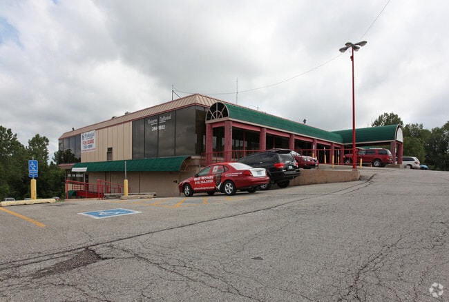
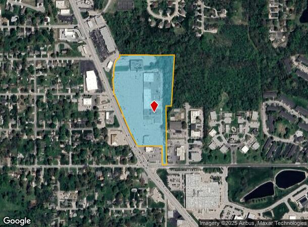
Property Record
2901 N Belt Hwy, Saint Joseph, MO 64506
NEARBY LISTINGS FOR SALE OR LEASE
Property Detail
2901 N Belt Hwy
St. Joseph, MO-KS
34-58-35SESUB: LOT: BLK:LGL DESC:BEG SE COR SE4 TH W 1147.09' N 21.47' TO POB W 50.94' N 219.39' W 292.05' TO E R/W/L BELT HW
03-8.0-34-004-000-027.004
Buchanan
Multifamilydwelling
Missouri
2023
14.78 AC
2025
St Joseph
000100
Kansas City
112,270 SF
DEMOGRAPHICS near 2901 N Belt Hwy
1 Mile
3 Mile
5 Mile
2024 Total Population
7,694
48,865
69,072
2029 Population
7,371
47,624
67,446
Pop Growth 2024-2029
(4.20%)
(2.54%)
(2.35%)
Average Age
41
40
40
2024 Total Households
2,976
19,440
27,773
HH Growth 2024-2029
(4.30%)
(2.57%)
(2.39%)
Median Household Inc
$55,896
$49,707
$49,785
Avg Household Size
2.30
2.30
2.30
2024 Avg HH Vehicles
2.00
2.00
2.00
Median Home Value
$188,549
$159,282
$153,495
Median Year Built
1973
1963
1964
Nearby Places
- Restaurants
- Banks
- Shops
- Fitness
- Groceries
SALE & LEASE HISTORY
LISTING DATE
SALE/LEASE

Sep 29, 2016
For Lease
Sep 25, 2016
For Lease
Mar 11, 2019
For Lease
Nearby Properties
Address
Land Use
TOTAL SIZE
Lot Size
Zoning
Address
Land Use
TOTAL SIZE
Lot Size
Zoning
Address
Land Use
TOTAL SIZE
Lot Size
Zoning
140,200 SF
141.50 AC
CITY
Address
Land Use
TOTAL SIZE
Lot Size
Zoning
151,500 SF
38.50 AC
CITY
Address
Land Use
TOTAL SIZE
Lot Size
Zoning
100,000 SF
53.47 AC
CITY
Address
Land Use
TOTAL SIZE
Lot Size
Zoning
39,440 SF
0.33 AC
CITY
Address
Land Use
TOTAL SIZE
Lot Size
Zoning
145,704 SF
18.66 AC
CITY
Address
Land Use
TOTAL SIZE
Lot Size
Zoning
86,591 SF
42.87 AC
CITY
Address
Land Use
TOTAL SIZE
Lot Size
Zoning
76,795 SF
13.55 AC
CITY
Address
Land Use
TOTAL SIZE
Lot Size
Zoning
80,991 SF
47.06 AC
CITY
Address
Land Use
TOTAL SIZE
Lot Size
Zoning
85,436 SF
1.40 AC
CITY
Address
Land Use
TOTAL SIZE
Lot Size
Zoning
30,864 SF
79.61 AC
CITY
Address
Land Use
TOTAL SIZE
Lot Size
Zoning
193,072 SF
11.90 AC
CITY
Address
Land Use
TOTAL SIZE
Lot Size
Zoning
63,996 SF
1.70 AC
CITY
Address
Land Use
TOTAL SIZE
Lot Size
Zoning
54,704 SF
1.40 AC
CITY
Address
Land Use
TOTAL SIZE
Lot Size
Zoning
31.19 AC
AOR
Address
Land Use
TOTAL SIZE
Lot Size
Zoning
55,216 SF
9.75 AC
CITY
Address
Land Use
TOTAL SIZE
Lot Size
Zoning
89,263 SF
12.58 AC
CITY
Address
Land Use
TOTAL SIZE
Lot Size
Zoning
108,284 SF
1.70 AC
CITY
Address
Land Use
TOTAL SIZE
Lot Size
Zoning
78,536 SF
21.60 AC
CITY
Address
Land Use
TOTAL SIZE
Lot Size
Zoning
80,978 SF
30.43 AC
CITY
Address
Land Use
TOTAL SIZE
Lot Size
Zoning
35,000 SF
5.31 AC
CITY
Address
Land Use
TOTAL SIZE
Lot Size
Zoning
66,905 SF
6.78 AC
CITY
Address
Land Use
TOTAL SIZE
Lot Size
Zoning
33,020 SF
10.11 AC
CITY
Address
Land Use
TOTAL SIZE
Lot Size
Zoning
41,050 SF
23.19 AC
CITY
Address
Land Use
TOTAL SIZE
Lot Size
Zoning
19,300 SF
1.51 AC
CITY
Address
Land Use
TOTAL SIZE
Lot Size
Zoning
41,932 SF
5.86 AC
CITY
Address
Land Use
TOTAL SIZE
Lot Size
Zoning
89,165 SF
23 AC
CITY
Address
Land Use
TOTAL SIZE
Lot Size
Zoning
113,908 SF
2.80 AC
CITY
Address
Land Use
TOTAL SIZE
Lot Size
Zoning
46,050 SF
8.57 AC
CITY
Address
Land Use
TOTAL SIZE
Lot Size
Zoning
37,952 SF
5.90 AC
CITY
The World's #1 Commercial Real Estate Marketplace
Connect with us
© 2025 CoStar Group
The information above has been obtained from sources believed reliable. While we do not doubt its accuracy we have not verified it and make no guarantee, warranty or representation about it. It is your responsibility to independently confirm its accuracy and completeness. Any projections, opinions, assumptions, or estimates used are for example only and do not represent the current or future performance of the property. The value of this transaction to you depends on tax and other factors which should be evaluated by your tax, financial, and legal advisors. You and your advisors should conduct a careful, independent investigation of the property to determine to your satisfaction the suitability of the property for your needs.