Property Record
2715 N Madison Ave, Tulsa, OK 74106
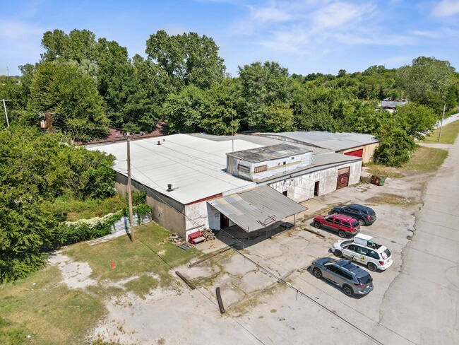

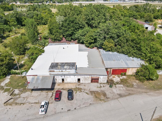
This Property Is For Sale
NEARBY LISTINGS FOR SALE OR LEASE
Property Detail
2715 N Madison Ave
90224-02-24-27350
Unplatted
Warehouse
BEG 25W & 663.73N SECR SW SE TH N128.87 W242.29 NE387.43 TO PT ON SL RD R/W NE347.63 E151.82 S514.94 TO PT ON NL RD R/W SWLY288.33 POB LESS .03AC OF CLU-D-SAC THEREOF SEC 24 20 12 5.514ACS
AE
Tulsa
40143C0228L
Oklahoma
2025
5.51 AC
2025
Northwest Tulsa
006200
Tulsa
14,200 SF
Tulsa, OK
DEMOGRAPHICS near 2715 N Madison Ave
1 Mile
3 Mile
5 Mile
2024 Total Population
9,033
62,381
131,542
2029 Population
9,570
65,618
137,824
Pop Growth 2024-2029
+ 5.94%
+ 5.19%
+ 4.78%
Average Age
37
37
38
2024 Total Households
3,781
23,319
53,589
HH Growth 2024-2029
+ 6.00%
+ 5.49%
+ 4.96%
Median Household Inc
$33,949
$42,527
$48,955
Avg Household Size
2.30
2.50
2.30
2024 Avg HH Vehicles
1.00
2.00
2.00
Median Home Value
$93,600
$87,937
$138,088
Median Year Built
1961
1958
1956
Nearby Places
Map Layers
Map Styles
 Street
 Aerial
- Restaurants
- Banks
- Shops
- Fitness
- Groceries
PUBLIC TRANSPORTATION
AIRPORT
Tulsa International
DRIVE
WALK
Distance
Tulsa International
12 min
6.3 mi
Freight Ports
Tulsa Port Of Catoosa
DRIVE
WALK
Distance
Tulsa Port Of Catoosa
22 min
14.4 mi
Nearby Properties
Address
Land Use
TOTAL SIZE
Lot Size
Zoning
Address
Land Use
TOTAL SIZE
Lot Size
Zoning
565,000 SF
10.62 AC
CBD
Address
Land Use
TOTAL SIZE
Lot Size
Zoning
692,068 SF
1.03 AC
CBD
Address
Land Use
TOTAL SIZE
Lot Size
Zoning
423,825 SF
23.97 AC
CBD
Address
Land Use
TOTAL SIZE
Lot Size
Zoning
10,736 SF
101.62 AC
Address
Land Use
TOTAL SIZE
Lot Size
Zoning
528,432 SF
0.01 AC
CBD
Address
Land Use
TOTAL SIZE
Lot Size
Zoning
74,284 SF
3.61 AC
IM
Address
Land Use
TOTAL SIZE
Lot Size
Zoning
254,800 SF
2.07 AC
CBD
Address
Land Use
TOTAL SIZE
Lot Size
Zoning
87,606 SF
8.25 AC
CBD
Address
Land Use
TOTAL SIZE
Lot Size
Zoning
92,407 SF
6.02 AC
CS
Address
Land Use
TOTAL SIZE
Lot Size
Zoning
266,944 SF
2.07 AC
CBD
Address
Land Use
TOTAL SIZE
Lot Size
Zoning
144,570 SF
44.59 AC
RM2
Address
Land Use
TOTAL SIZE
Lot Size
Zoning
94,115 SF
15.18 AC
IM
Address
Land Use
TOTAL SIZE
Lot Size
Zoning
56,049 SF
1.14 AC
CBD
Address
Land Use
TOTAL SIZE
Lot Size
Zoning
161,670 SF
8.57 AC
IL
Address
Land Use
TOTAL SIZE
Lot Size
Zoning
106,579 SF
6.76 AC
RM1
Address
Land Use
TOTAL SIZE
Lot Size
Zoning
53,337 SF
3.34 AC
FBC
Address
Land Use
TOTAL SIZE
Lot Size
Zoning
410,400 SF
1.76 AC
CBD
Address
Land Use
TOTAL SIZE
Lot Size
Zoning
1,298,531 SF
2.49 AC
CBD
Address
Land Use
TOTAL SIZE
Lot Size
Zoning
102,092 SF
0.96 AC
CBD
Address
Land Use
TOTAL SIZE
Lot Size
Zoning
333,000 SF
1.38 AC
CBD
Address
Land Use
TOTAL SIZE
Lot Size
Zoning
195,492 SF
17.11 AC
RM1
Address
Land Use
TOTAL SIZE
Lot Size
Zoning
54,684 SF
0.96 AC
CBD
Address
Land Use
TOTAL SIZE
Lot Size
Zoning
333,000 SF
1.32 AC
CBD
Address
Land Use
TOTAL SIZE
Lot Size
Zoning
56,476 SF
2.89 AC
RM2
Address
Land Use
TOTAL SIZE
Lot Size
Zoning
342,608 SF
2.58 AC
CBD
Address
Land Use
TOTAL SIZE
Lot Size
Zoning
38,908 SF
2.39 AC
IM
Address
Land Use
TOTAL SIZE
Lot Size
Zoning
67,334 SF
0.84 AC
IL
Address
Land Use
TOTAL SIZE
Lot Size
Zoning
333,000 SF
1.28 AC
CBD
Address
Land Use
TOTAL SIZE
Lot Size
Zoning
121,518 SF
8.52 AC
IM
The World's #1 Commercial Real Estate Marketplace
Connect with us
© 2026 CoStar Group
The information above has been obtained from sources believed reliable. While we do not doubt its accuracy we have not verified it and make no guarantee, warranty or representation about it. It is your responsibility to independently confirm its accuracy and completeness. Any projections, opinions, assumptions, or estimates used are for example only and do not represent the current or future performance of the property. The value of this transaction to you depends on tax and other factors which should be evaluated by your tax, financial, and legal advisors. You and your advisors should conduct a careful, independent investigation of the property to determine to your satisfaction the suitability of the property for your needs.