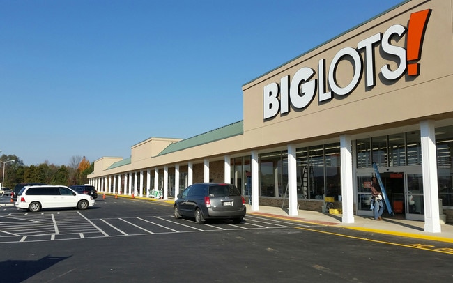
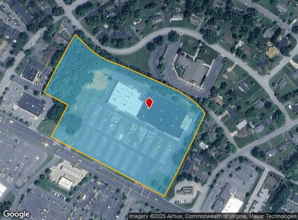
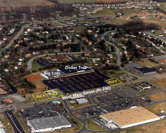
Property Record
2715 W Main St, Waynesboro, VA 22980
NEARBY LISTINGS FOR SALE OR LEASE
Property Detail
2715 W Main St
21 1 - 64A
Minor Sd
Commercialnec
PARCEL 2 (13.O93 AC ON N SIDE OF RT 250 ADJ VA VILLAGE) SMALL ACREAGE (2007 REPLAT)
X
Waynesboro
51125C0025C
Virginia
2025
13.09 AC
2025
Staunton & Harrisonburg
003400
Other Market Areas
77,963 SF
Staunton-Waynesboro, VA
DEMOGRAPHICS near 2715 W Main St
1 Mile
3 Mile
5 Mile
2024 Total Population
4,703
26,810
41,431
2029 Population
4,985
28,507
43,844
Pop Growth 2024-2029
+ 6.00%
+ 6.33%
+ 5.82%
Average Age
46
43
43
2024 Total Households
1,963
11,358
17,280
HH Growth 2024-2029
+ 5.96%
+ 6.40%
+ 5.95%
Median Household Inc
$82,968
$57,684
$55,660
Avg Household Size
2.30
2.30
2.30
2024 Avg HH Vehicles
2.00
2.00
2.00
Median Home Value
$274,999
$251,706
$241,967
Median Year Built
1989
1977
1983
Nearby Places
Map Layers
Map Styles
 Street
 Aerial
- Restaurants
- Banks
- Shops
- Fitness
- Groceries
PUBLIC TRANSPORTATION
COMMUTER RAIL
Staunton Amtrak Station (Cardinal - Amtrak)
DRIVE
WALK
Distance
Staunton Amtrak Station (Cardinal - Amtrak)
16 min
9.5 mi
AIRPORT
Charlottesville-Albemarle
DRIVE
WALK
Distance
Charlottesville-Albemarle
53 min
37.6 mi
Freight Ports
Virginia Port Authority - Richmond
DRIVE
WALK
Distance
Virginia Port Authority - Richmond
125 min
105.6 mi
SALE & LEASE HISTORY
LISTING DATE
SALE/LEASE

Sep 25, 2016
For Lease
Nearby Properties
Address
Land Use
TOTAL SIZE
Lot Size
Zoning
Address
Land Use
TOTAL SIZE
Lot Size
Zoning
94,995 SF
20.92 AC
H-B
Address
Land Use
TOTAL SIZE
Lot Size
Zoning
150,944 SF
22.24 AC
RG-5
Address
Land Use
TOTAL SIZE
Lot Size
Zoning
165,670 SF
5.31 AC
R-O
Address
Land Use
TOTAL SIZE
Lot Size
Zoning
25,100 SF
11.54 AC
PUD
Address
Land Use
TOTAL SIZE
Lot Size
Zoning
11,510 SF
8.31 AC
PUD
Address
Land Use
TOTAL SIZE
Lot Size
Zoning
73,371 SF
13.23 AC
H-B
Address
Land Use
TOTAL SIZE
Lot Size
Zoning
10,527 SF
140.52 AC
RS-12
Address
Land Use
TOTAL SIZE
Lot Size
Zoning
2.08 AC
RG-5
Address
Land Use
TOTAL SIZE
Lot Size
Zoning
191,715 SF
22.54 AC
H-B
Address
Land Use
TOTAL SIZE
Lot Size
Zoning
48,888 SF
9.01 AC
RG-5
Address
Land Use
TOTAL SIZE
Lot Size
Zoning
121,275 SF
18.39 AC
RG-5
Address
Land Use
TOTAL SIZE
Lot Size
Zoning
947 SF
13.62 AC
RG-5
Address
Land Use
TOTAL SIZE
Lot Size
Zoning
29,582 SF
5.36 AC
PUD
Address
Land Use
TOTAL SIZE
Lot Size
Zoning
138,341 SF
18.94 AC
H-B
Address
Land Use
TOTAL SIZE
Lot Size
Zoning
312,551 SF
23.37 AC
L-I
Address
Land Use
TOTAL SIZE
Lot Size
Zoning
301,338 SF
21.52 AC
H-I
Address
Land Use
TOTAL SIZE
Lot Size
Zoning
128,670 SF
10.15 AC
H-B
Address
Land Use
TOTAL SIZE
Lot Size
Zoning
15,304 SF
13.39 AC
RS-12
Address
Land Use
TOTAL SIZE
Lot Size
Zoning
75,609 SF
12.01 AC
RS-7
Address
Land Use
TOTAL SIZE
Lot Size
Zoning
58,713 SF
3.52 AC
H-B
Address
Land Use
TOTAL SIZE
Lot Size
Zoning
8,050 SF
4.50 AC
R-MF
Address
Land Use
TOTAL SIZE
Lot Size
Zoning
96,070 SF
27.10 AC
H-B
Address
Land Use
TOTAL SIZE
Lot Size
Zoning
104,940 SF
17.26 AC
H-B
Address
Land Use
TOTAL SIZE
Lot Size
Zoning
69,455 SF
2.59 AC
H-B
Address
Land Use
TOTAL SIZE
Lot Size
Zoning
39,748 SF
28.84 AC
GENERAL BU
Address
Land Use
TOTAL SIZE
Lot Size
Zoning
5,624 SF
74.80 AC
H-I
Address
Land Use
TOTAL SIZE
Lot Size
Zoning
31,977 SF
5.07 AC
RS-12
Address
Land Use
TOTAL SIZE
Lot Size
Zoning
460 SF
144.09 AC
H-I
Address
Land Use
TOTAL SIZE
Lot Size
Zoning
54,400 SF
9.33 AC
H-B
Address
Land Use
TOTAL SIZE
Lot Size
Zoning
7,512 SF
6.39 AC
R-MF
The World's #1 Commercial Real Estate Marketplace
Connect with us
© 2025 CoStar Group
The information above has been obtained from sources believed reliable. While we do not doubt its accuracy we have not verified it and make no guarantee, warranty or representation about it. It is your responsibility to independently confirm its accuracy and completeness. Any projections, opinions, assumptions, or estimates used are for example only and do not represent the current or future performance of the property. The value of this transaction to you depends on tax and other factors which should be evaluated by your tax, financial, and legal advisors. You and your advisors should conduct a careful, independent investigation of the property to determine to your satisfaction the suitability of the property for your needs.