Property Record
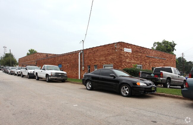
175 N Arcadia Ave, Decatur, GA 30030


Property Detail
175 N Arcadia Ave
15-248-30-003
375 X 86 X 258 X 104 X
Regionalshoppingcenterormallwithanchorstore
DeKalb
M
Georgia
B and X Area of moderate flood hazard, usually the area between the limits of the 100-year and 500-year floods.
3
2025
6.47 AC
2025
Stone Mountain
022203
Atlanta
65,404 SF
Atlanta-Sandy Springs-Roswell, GA
NEARBY LISTINGS FOR SALE OR LEASE
DEMOGRAPHICS near 175 N Arcadia Ave
1 mile
3 mile
5 mile
2025 Total Population
14,192
117,892
314,997
2030 Population
14,672
120,582
321,015
Pop Growth 2025-2030
+ 3.38%
+ 2.28%
+ 1.91%
Average Age
41
39
39
2025 Total Households
6,660
49,179
131,442
HH Growth 2025-2030
+ 3.51%
+ 2.43%
+ 1.96%
Median Household Inc
$109,447
$99,062
$90,769
Avg Household Size
2.10
2.30
2.30
2025 Avg HH Vehicles
2.00
2.00
2.00
Median Home Value
$507,249
$482,864
$453,723
Median Year Built
1989
1975
1974
Nearby Places
Map Layers
Map Styles
 Street
 Aerial
Layers
 Traffic
 Biking
Places
Listings with unknown addresses are not visible on the map
- Restaurants
- Banks
- Shops
- Fitness
- Groceries
PUBLIC TRANSPORTATION
TRANSIT/SUBWAY
Avondale (Blue Line - Metropolitan Atlanta Rapid Transit Authority (MARTA))
Drive
Walk
Distance
Avondale (Blue Line - Metropolitan Atlanta Rapid Transit Authority (MARTA))
1 min
8 min
0.4 mi
COMMUTER RAIL
Atlanta (Crescent - Amtrak)
Drive
Walk
Distance
Atlanta (Crescent - Amtrak)
19 min
8.9 mi
AIRPORT
Hartsfield - Jackson Atlanta International
Drive
Walk
Distance
Hartsfield - Jackson Atlanta International
28 min
16.1 mi
Freight Ports
Georgia Ports - Savannah
Drive
Walk
Distance
Georgia Ports - Savannah
283 min
251.9 mi
SALE & LEASE HISTORY
LISTING DATE
SALE/LEASE

Sep 24, 2016
For Sale
Nearby Properties
Address
Land Use
TOTAL SIZE
Lot Size
Zoning
Address
Land Use
TOTAL SIZE
Lot Size
Zoning
2,612 SF
137.60 AC
X
Address
Land Use
TOTAL SIZE
Lot Size
Zoning
123,089 SF
5.07 AC
MU-4
Address
Land Use
TOTAL SIZE
Lot Size
Zoning
78,008 SF
11.16 AC
HR-3
Address
Land Use
TOTAL SIZE
Lot Size
Zoning
123,732 SF
0.51 AC
RM75
Address
Land Use
TOTAL SIZE
Lot Size
Zoning
327,098 SF
4.92 AC
X
Address
Land Use
TOTAL SIZE
Lot Size
Zoning
393,333 SF
5.37 AC
X
Address
Land Use
TOTAL SIZE
Lot Size
Zoning
140,724 SF
19.98 AC
MR-1
Address
Land Use
TOTAL SIZE
Lot Size
Zoning
99,770 SF
2.14 AC
Address
Land Use
TOTAL SIZE
Lot Size
Zoning
158,294 SF
9.41 AC
OI
Address
Land Use
TOTAL SIZE
Lot Size
Zoning
174,052 SF
4.15 AC
MU-5
Address
Land Use
TOTAL SIZE
Lot Size
Zoning
225,500 SF
9.74 AC
RM75
Address
Land Use
TOTAL SIZE
Lot Size
Zoning
357,531 SF
11.51 AC
RM75
Address
Land Use
TOTAL SIZE
Lot Size
Zoning
202,577 SF
2.97 AC
OI
Address
Land Use
TOTAL SIZE
Lot Size
Zoning
249,774 SF
15.57 AC
RM-HD
Address
Land Use
TOTAL SIZE
Lot Size
Zoning
350,556 SF
46.09 AC
X
Address
Land Use
TOTAL SIZE
Lot Size
Zoning
455,599 SF
43.15 AC
HR-3
Address
Land Use
TOTAL SIZE
Lot Size
Zoning
166,663 SF
8.65 AC
X
Address
Land Use
TOTAL SIZE
Lot Size
Zoning
259,834 SF
3.56 AC
OI
Address
Land Use
TOTAL SIZE
Lot Size
Zoning
296,175 SF
18.95 AC
RM100
Address
Land Use
TOTAL SIZE
Lot Size
Zoning
244,293 SF
2.09 AC
C-2
Address
Land Use
TOTAL SIZE
Lot Size
Zoning
298,763 SF
3.27 AC
M
Address
Land Use
TOTAL SIZE
Lot Size
Zoning
185,074 SF
10.49 AC
RM-HD
Address
Land Use
TOTAL SIZE
Lot Size
Zoning
214,505 SF
11.65 AC
C-1
Address
Land Use
TOTAL SIZE
Lot Size
Zoning
295,718 SF
25.64 AC
RM85
Address
Land Use
TOTAL SIZE
Lot Size
Zoning
104,501 SF
2.56 AC
X
Address
Land Use
TOTAL SIZE
Lot Size
Zoning
174,443 SF
9.46 AC
TND
Address
Land Use
TOTAL SIZE
Lot Size
Zoning
247,880 SF
14.82 AC
RM85
Address
Land Use
TOTAL SIZE
Lot Size
Zoning
76,500 SF
2.84 AC
X
Address
Land Use
TOTAL SIZE
Lot Size
Zoning
166,174 SF
19.70 AC
RM85
Address
Land Use
TOTAL SIZE
Lot Size
Zoning
93,584 SF
0.66 AC
X
The World's #1 Commercial Real Estate Marketplace
Connect with us
© 2026 CoStar Group
The information above has been obtained from sources believed reliable. While we do not doubt its accuracy we have not verified it and make no guarantee, warranty or representation about it. It is your responsibility to independently confirm its accuracy and completeness. Any projections, opinions, assumptions, or estimates used are for example only and do not represent the current or future performance of the property. The value of this transaction to you depends on tax and other factors which should be evaluated by your tax, financial, and legal advisors. You and your advisors should conduct a careful, independent investigation of the property to determine to your satisfaction the suitability of the property for your needs.