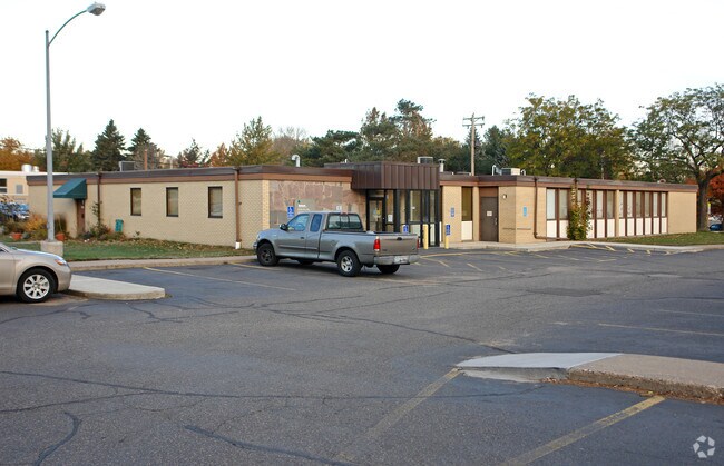
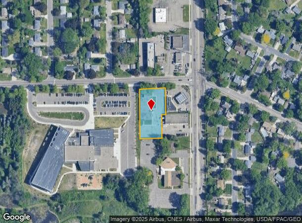
Property Record
2716 Upper Afton Rd E, Saint Paul, MN 55119

NEARBY LISTINGS FOR SALE OR LEASE
Property Detail
2716 Upper Afton Rd E
Minneapolis-St. Paul-Bloomington, MN-WI
Condo No 287 Afton Rd Clinc Co
01-28-22-41-0012
CONDO NO 287 AFTON RD CLINC CO UNIT NO.27161
Medicalbuilding
Ramsey
X
Minnesota
27123C0130G
27161
2024
0.69 AC
2025
Suburban St Paul
042504
Minneapolis/St Paul
8,583 SF
DEMOGRAPHICS near 2716 Upper Afton Rd E
1 Mile
3 Mile
5 Mile
2024 Total Population
5,938
78,922
227,239
2029 Population
6,190
80,347
231,164
Pop Growth 2024-2029
+ 4.24%
+ 1.81%
+ 1.73%
Average Age
39
38
37
2024 Total Households
2,196
29,891
83,355
HH Growth 2024-2029
+ 4.37%
+ 2.18%
+ 2.04%
Median Household Inc
$71,455
$74,279
$75,357
Avg Household Size
2.60
2.50
2.60
2024 Avg HH Vehicles
2.00
2.00
2.00
Median Home Value
$253,186
$268,700
$280,113
Median Year Built
1969
1978
1976
Nearby Places
Map Layers
Map Styles
 Street
 Aerial
- Restaurants
- Banks
- Shops
- Fitness
- Groceries
PUBLIC TRANSPORTATION
AIRPORT
Minneapolis-St Paul International/Wold-Chamberlain
DRIVE
WALK
Distance
Minneapolis-St Paul International/Wold-Chamberlain
25 min
15.5 mi
SALE & LEASE HISTORY
LISTING DATE
SALE/LEASE

Oct 28, 2017
For Lease
Oct 28, 2017
For Sale
Dec 14, 2023
For Lease
Nearby Properties
Address
Land Use
TOTAL SIZE
Lot Size
Zoning
Address
Land Use
TOTAL SIZE
Lot Size
Zoning
267,948 SF
372.92 AC
Address
Land Use
TOTAL SIZE
Lot Size
Zoning
114,777 SF
22.45 AC
Address
Land Use
TOTAL SIZE
Lot Size
Zoning
270,348 SF
35.96 AC
Address
Land Use
TOTAL SIZE
Lot Size
Zoning
335,655 SF
Address
Land Use
TOTAL SIZE
Lot Size
Zoning
127,888 SF
141.04 AC
Address
Land Use
TOTAL SIZE
Lot Size
Zoning
47,717 SF
10.10 AC
Address
Land Use
TOTAL SIZE
Lot Size
Zoning
460,439 SF
25.26 AC
Address
Land Use
TOTAL SIZE
Lot Size
Zoning
29.55 AC
Address
Land Use
TOTAL SIZE
Lot Size
Zoning
296,529 SF
31.80 AC
Address
Land Use
TOTAL SIZE
Lot Size
Zoning
228,036 SF
31.11 AC
Address
Land Use
TOTAL SIZE
Lot Size
Zoning
81,006 SF
12.05 AC
Address
Land Use
TOTAL SIZE
Lot Size
Zoning
147,199 SF
32.47 AC
Address
Land Use
TOTAL SIZE
Lot Size
Zoning
311,332 SF
36.34 AC
Address
Land Use
TOTAL SIZE
Lot Size
Zoning
181.88 AC
Address
Land Use
TOTAL SIZE
Lot Size
Zoning
85,400 SF
6.43 AC
Address
Land Use
TOTAL SIZE
Lot Size
Zoning
551,440 SF
25.40 AC
Address
Land Use
TOTAL SIZE
Lot Size
Zoning
9.90 AC
Address
Land Use
TOTAL SIZE
Lot Size
Zoning
230,892 SF
43.62 AC
Address
Land Use
TOTAL SIZE
Lot Size
Zoning
41,868 SF
6.69 AC
Address
Land Use
TOTAL SIZE
Lot Size
Zoning
262,872 SF
14.22 AC
Address
Land Use
TOTAL SIZE
Lot Size
Zoning
13.43 AC
Address
Land Use
TOTAL SIZE
Lot Size
Zoning
41,201 SF
9.55 AC
Address
Land Use
TOTAL SIZE
Lot Size
Zoning
371,200 SF
8.99 AC
Address
Land Use
TOTAL SIZE
Lot Size
Zoning
Address
Land Use
TOTAL SIZE
Lot Size
Zoning
Address
Land Use
TOTAL SIZE
Lot Size
Zoning
75,825 SF
19.49 AC
Address
Land Use
TOTAL SIZE
Lot Size
Zoning
111,528 SF
20.30 AC
Address
Land Use
TOTAL SIZE
Lot Size
Zoning
78,278 SF
4.08 AC
Address
Land Use
TOTAL SIZE
Lot Size
Zoning
188,160 SF
7.53 AC
The World's #1 Commercial Real Estate Marketplace
Connect with us
© 2025 CoStar Group
The information above has been obtained from sources believed reliable. While we do not doubt its accuracy we have not verified it and make no guarantee, warranty or representation about it. It is your responsibility to independently confirm its accuracy and completeness. Any projections, opinions, assumptions, or estimates used are for example only and do not represent the current or future performance of the property. The value of this transaction to you depends on tax and other factors which should be evaluated by your tax, financial, and legal advisors. You and your advisors should conduct a careful, independent investigation of the property to determine to your satisfaction the suitability of the property for your needs.