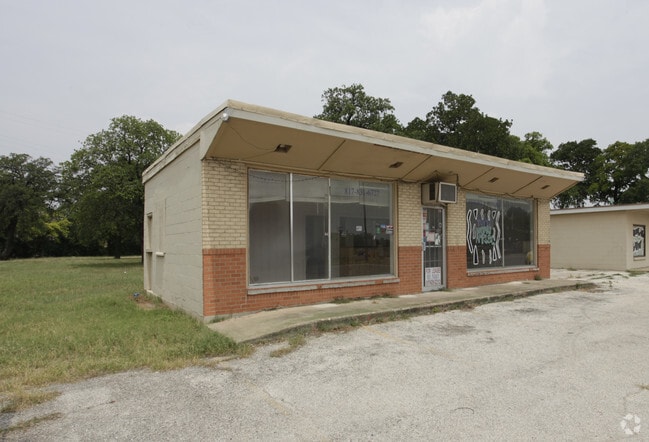
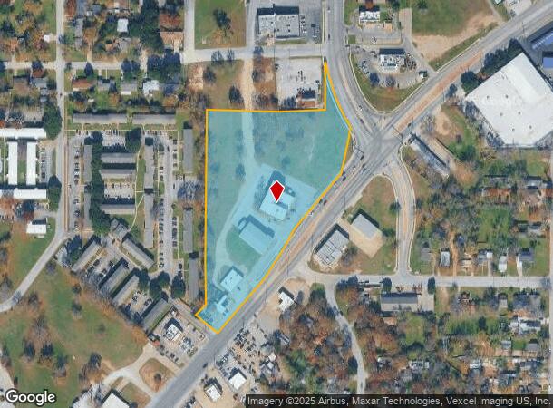
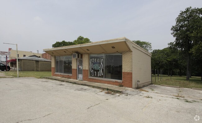
Property Record
2715 Denton Hwy, Haltom City, TX 76117
NEARBY LISTINGS FOR SALE OR LEASE
Property Detail
2715 Denton Hwy
03715612
Akers, Simon Survey
Commercialnec
AKERS, SIMON SURVEY ABSTRACT 17 TRACT 2C & 2D1C AND 2F (CLOSED ROW)
X
Tarrant
48439C0195L
Texas
2024
5.76 AC
2025
Haltom City
110102
Dallas/Ft Worth
18,234 SF
Dallas-Fort Worth-Arlington, TX
DEMOGRAPHICS near 2715 Denton Hwy
1 Mile
3 Mile
5 Mile
2024 Total Population
11,482
72,322
252,872
2029 Population
12,088
76,010
267,530
Pop Growth 2024-2029
+ 5.28%
+ 5.10%
+ 5.80%
Average Age
37
37
37
2024 Total Households
3,897
25,838
92,621
HH Growth 2024-2029
+ 5.39%
+ 5.10%
+ 5.99%
Median Household Inc
$46,923
$54,125
$57,478
Avg Household Size
2.80
2.70
2.60
2024 Avg HH Vehicles
2.00
2.00
2.00
Median Home Value
$156,677
$195,699
$212,181
Median Year Built
1962
1966
1979
Nearby Places
- Restaurants
- Banks
- Shops
- Fitness
- Groceries
PUBLIC TRANSPORTATION
COMMUTER RAIL
Richland Hills (Trinity Railway Express - Dallas Area Rapid Transit (DART))
DRIVE
WALK
Distance
Richland Hills (Trinity Railway Express - Dallas Area Rapid Transit (DART))
7 min
4.0 mi
Trinity Lakes Station (TRINITY RAILWAY - Dallas Area Rapid Transit (DART))
DRIVE
WALK
Distance
Trinity Lakes Station (TRINITY RAILWAY - Dallas Area Rapid Transit (DART))
8 min
4.1 mi
AIRPORT
Dallas-Fort Worth International
DRIVE
WALK
Distance
Dallas-Fort Worth International
28 min
19.4 mi
Dallas Love Field
DRIVE
WALK
Distance
Dallas Love Field
38 min
28.1 mi
Freight Ports
Port of Shreveport
DRIVE
WALK
Distance
Port of Shreveport
248 min
227.3 mi
Nearby Properties
Address
Land Use
TOTAL SIZE
Lot Size
Zoning
Address
Land Use
TOTAL SIZE
Lot Size
Zoning
699,246 SF
40.69 AC
Address
Land Use
TOTAL SIZE
Lot Size
Zoning
385,697 SF
15.94 AC
Address
Land Use
TOTAL SIZE
Lot Size
Zoning
810,978 SF
45.84 AC
Address
Land Use
TOTAL SIZE
Lot Size
Zoning
231,871 SF
17.08 AC
Address
Land Use
TOTAL SIZE
Lot Size
Zoning
697,140 SF
37.84 AC
Address
Land Use
TOTAL SIZE
Lot Size
Zoning
248,993 SF
15.40 AC
Address
Land Use
TOTAL SIZE
Lot Size
Zoning
293,972 SF
17.30 AC
Address
Land Use
TOTAL SIZE
Lot Size
Zoning
566,816 SF
32.79 AC
Address
Land Use
TOTAL SIZE
Lot Size
Zoning
459,540 SF
36.02 AC
Address
Land Use
TOTAL SIZE
Lot Size
Zoning
221,946 SF
31.17 AC
Address
Land Use
TOTAL SIZE
Lot Size
Zoning
197,131 SF
43.78 AC
Address
Land Use
TOTAL SIZE
Lot Size
Zoning
241,064 SF
12.63 AC
Address
Land Use
TOTAL SIZE
Lot Size
Zoning
526,195 SF
40.84 AC
Address
Land Use
TOTAL SIZE
Lot Size
Zoning
306,524 SF
24.92 AC
Address
Land Use
TOTAL SIZE
Lot Size
Zoning
204,948 SF
23.93 AC
Address
Land Use
TOTAL SIZE
Lot Size
Zoning
427,908 SF
22.04 AC
Address
Land Use
TOTAL SIZE
Lot Size
Zoning
764,254 SF
40.80 AC
Address
Land Use
TOTAL SIZE
Lot Size
Zoning
141,276 SF
12.04 AC
Address
Land Use
TOTAL SIZE
Lot Size
Zoning
125,838 SF
12.38 AC
Address
Land Use
TOTAL SIZE
Lot Size
Zoning
185,047 SF
10 AC
Address
Land Use
TOTAL SIZE
Lot Size
Zoning
214,083 SF
19.84 AC
Address
Land Use
TOTAL SIZE
Lot Size
Zoning
106,045 SF
9.64 AC
Address
Land Use
TOTAL SIZE
Lot Size
Zoning
112,000 SF
12.85 AC
Address
Land Use
TOTAL SIZE
Lot Size
Zoning
93,586 SF
7.93 AC
Address
Land Use
TOTAL SIZE
Lot Size
Zoning
146,000 SF
8.54 AC
Address
Land Use
TOTAL SIZE
Lot Size
Zoning
148,720 SF
8.04 AC
Address
Land Use
TOTAL SIZE
Lot Size
Zoning
93,380 SF
8.64 AC
Address
Land Use
TOTAL SIZE
Lot Size
Zoning
300,000 SF
16.60 AC
Address
Land Use
TOTAL SIZE
Lot Size
Zoning
131,607 SF
8.69 AC
Address
Land Use
TOTAL SIZE
Lot Size
Zoning
162,800 SF
11.52 AC
The World's #1 Commercial Real Estate Marketplace
Connect with us
© 2025 CoStar Group
The information above has been obtained from sources believed reliable. While we do not doubt its accuracy we have not verified it and make no guarantee, warranty or representation about it. It is your responsibility to independently confirm its accuracy and completeness. Any projections, opinions, assumptions, or estimates used are for example only and do not represent the current or future performance of the property. The value of this transaction to you depends on tax and other factors which should be evaluated by your tax, financial, and legal advisors. You and your advisors should conduct a careful, independent investigation of the property to determine to your satisfaction the suitability of the property for your needs.