Property Record
272 Pritchard Rd, Clayton, NC 27527
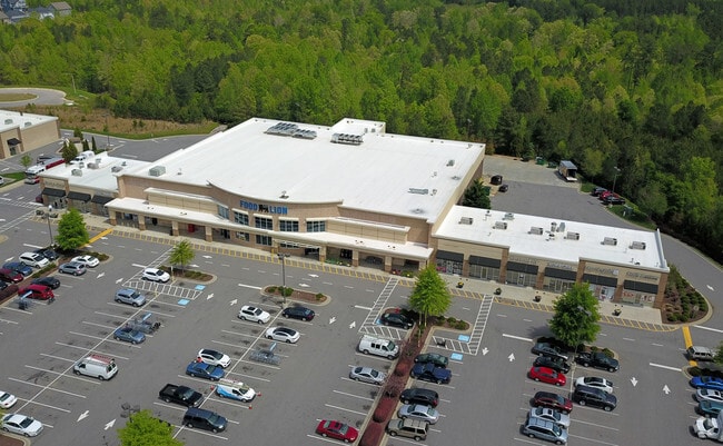

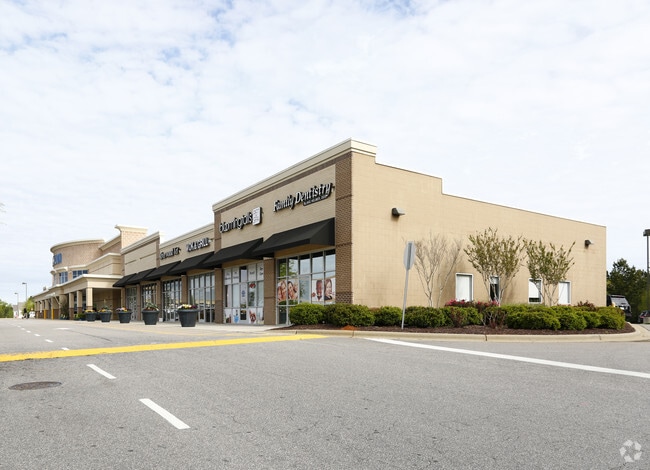
Property Detail
272 Pritchard Rd
16I02008H
LT 4 74/132 1760
Stripcommercialcenter
Johnston
PUD
North Carolina
B and X Area of moderate flood hazard, usually the area between the limits of the 100-year and 500-year floods.
4
2025
6.52 AC
2025
Johnston County
040209
Raleigh/Durham
51,494 SF
Raleigh-Cary, NC
NEARBY LISTINGS FOR SALE OR LEASE
DEMOGRAPHICS near 272 Pritchard Rd
1 mile
3 mile
5 mile
2025 Total Population
4,675
14,062
65,147
2030 Population
5,202
15,714
73,031
Pop Growth 2025-2030
+ 11.27%
+ 11.75%
+ 12.10%
Average Age
35
37
38
2025 Total Households
1,514
4,833
23,523
HH Growth 2025-2030
+ 11.29%
+ 11.79%
+ 12.22%
Median Household Inc
$105,123
$105,179
$98,822
Avg Household Size
3.00
2.90
2.70
2025 Avg HH Vehicles
2.00
2.00
2.00
Median Home Value
$376,666
$390,805
$375,475
Median Year Built
2010
2008
2006
Nearby Places
Map Layers
Map Styles
 Street
 Aerial
Layers
 Traffic
 Biking
Places
Listings with unknown addresses are not visible on the map
- Restaurants
- Banks
- Shops
- Fitness
- Groceries
PUBLIC TRANSPORTATION
AIRPORT
Raleigh-Durham International
Drive
Walk
Distance
Raleigh-Durham International
43 min
33.2 mi
Freight Ports
Port of Wilmington
Drive
Walk
Distance
Port of Wilmington
154 min
130.1 mi
SALE & LEASE HISTORY
LISTING DATE
SALE/LEASE

Nov 06, 2017
For Lease
Nearby Properties
Address
Land Use
TOTAL SIZE
Lot Size
Zoning
Address
Land Use
TOTAL SIZE
Lot Size
Zoning
16,236 SF
45.70 AC
RES
Address
Land Use
TOTAL SIZE
Lot Size
Zoning
18,000 SF
249.20 AC
IND
Address
Land Use
TOTAL SIZE
Lot Size
Zoning
1,008 SF
334.15 AC
R-30
Address
Land Use
TOTAL SIZE
Lot Size
Zoning
3,600 SF
221.51 AC
R-30
Address
Land Use
TOTAL SIZE
Lot Size
Zoning
7,568 SF
1.48 AC
COM
Address
Land Use
TOTAL SIZE
Lot Size
Zoning
5,550 SF
2.29 AC
COM
Address
Land Use
TOTAL SIZE
Lot Size
Zoning
7,488 SF
1.35 AC
COM
Address
Land Use
TOTAL SIZE
Lot Size
Zoning
7,568 SF
1.64 AC
COM
Address
Land Use
TOTAL SIZE
Lot Size
Zoning
173.95 AC
R-30
Address
Land Use
TOTAL SIZE
Lot Size
Zoning
15,360 SF
1.17 AC
COM
Address
Land Use
TOTAL SIZE
Lot Size
Zoning
559.24 AC
PUD
Address
Land Use
TOTAL SIZE
Lot Size
Zoning
7,568 SF
1.51 AC
COM
Address
Land Use
TOTAL SIZE
Lot Size
Zoning
7,488 SF
1.20 AC
COM
Address
Land Use
TOTAL SIZE
Lot Size
Zoning
14,400 SF
181.56 AC
RAG
Address
Land Use
TOTAL SIZE
Lot Size
Zoning
260 SF
135.46 AC
R-30
Address
Land Use
TOTAL SIZE
Lot Size
Zoning
39.55 AC
COM
Address
Land Use
TOTAL SIZE
Lot Size
Zoning
1,350 SF
277.95 AC
RAG
Address
Land Use
TOTAL SIZE
Lot Size
Zoning
110.47 AC
R-30
Address
Land Use
TOTAL SIZE
Lot Size
Zoning
101 AC
R-30
Address
Land Use
TOTAL SIZE
Lot Size
Zoning
4,522 SF
200.01 AC
SUP
Address
Land Use
TOTAL SIZE
Lot Size
Zoning
8,092 SF
5.03 AC
RES
Address
Land Use
TOTAL SIZE
Lot Size
Zoning
68,970 SF
5.94 AC
PUD
Address
Land Use
TOTAL SIZE
Lot Size
Zoning
7,488 SF
0.74 AC
COM
Address
Land Use
TOTAL SIZE
Lot Size
Zoning
325.71 AC
PUD
Address
Land Use
TOTAL SIZE
Lot Size
Zoning
14,712 SF
7.96 AC
OFF
Address
Land Use
TOTAL SIZE
Lot Size
Zoning
14,308 SF
1.23 AC
COM
Address
Land Use
TOTAL SIZE
Lot Size
Zoning
1,048 SF
67.68 AC
R-30
Address
Land Use
TOTAL SIZE
Lot Size
Zoning
161.09 AC
PUD
The World's #1 Commercial Real Estate Marketplace
Connect with us
© 2026 CoStar Group
The information above has been obtained from sources believed reliable. While we do not doubt its accuracy we have not verified it and make no guarantee, warranty or representation about it. It is your responsibility to independently confirm its accuracy and completeness. Any projections, opinions, assumptions, or estimates used are for example only and do not represent the current or future performance of the property. The value of this transaction to you depends on tax and other factors which should be evaluated by your tax, financial, and legal advisors. You and your advisors should conduct a careful, independent investigation of the property to determine to your satisfaction the suitability of the property for your needs.