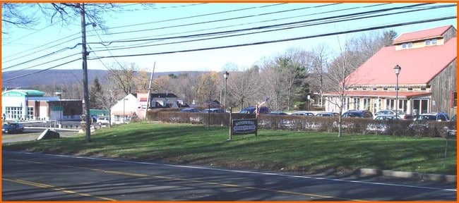
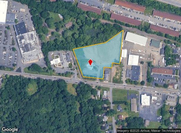
Property Record
272 Rt 59, Suffern, NY 10901
NEARBY LISTINGS FOR SALE OR LEASE
-
-
-
-
-
-
-
No Photo
-
View all Suffern listings for sale on LoopNet.com
Property Detail
272 Rt 59
392621-055-012-0001-005-000-0000
Rockland
Commercialacreage
New York
X
5.0
34003C0076H
3.12 AC
2023
Ramapo
2024
Northern New Jersey
011602
New York-Jersey City-White Plains, NY-NJ
3,936 SF
DEMOGRAPHICS near 272 Rt 59
1 mile
3 mile
5 mile
2024 Total Population
8,659
111,126
212,827
2029 Population
8,694
110,715
212,149
Pop Growth 2024-2029
+ 0.40%
(0.37%)
(0.32%)
Average Age
37
33
35
2024 Total Households
2,504
30,504
61,096
HH Growth 2024-2029
+ 0.44%
(0.30%)
(0.26%)
Median Household Inc
$86,882
$85,451
$95,981
Avg Household Size
3.20
3.40
3.30
2024 Avg HH Vehicles
2.00
2.00
2.00
Median Home Value
$750,530
$630,760
$615,143
Median Year Built
1989
1975
1975
Nearby Places
Map Layers
Map Styles
 Street
 Aerial
Transit
 Traffic
 Biking
Places
Listings with unknown addresses are not visible on the map
- Restaurants
- Banks
- Shops
- Fitness
- Groceries
PUBLIC TRANSPORTATION
COMMUTER RAIL
Suffern (Bergen County/Port Jervis Line - NJ Transit Commuter Rail (NJ Transit), Main/Port Jervis Line - NJ Transit Commuter Rail (NJ Transit))
Drive
Walk
Distance
Suffern (Bergen County/Port Jervis Line - NJ Transit Commuter Rail (NJ Transit), Main/Port Jervis Line - NJ Transit Commuter Rail (NJ Transit))
6 min
3.0 mi
Spring Valley (Pascack Valley Line - NJ Transit Commuter Rail (NJ Transit))
Drive
Walk
Distance
Spring Valley (Pascack Valley Line - NJ Transit Commuter Rail (NJ Transit))
6 min
3.4 mi
AIRPORT
Westchester County
Drive
Walk
Distance
Westchester County
41 min
27.9 mi
LaGuardia
Drive
Walk
Distance
LaGuardia
54 min
36.9 mi
New York Stewart International
Drive
Walk
Distance
New York Stewart International
51 min
38.3 mi
Freight Ports
Maher Terminal
Drive
Walk
Distance
Maher Terminal
54 min
39.8 mi
Nearby Properties
Address
Land Use
TOTAL SIZE
Lot Size
Zoning
Address
Land Use
TOTAL SIZE
Lot Size
Zoning
1,056 SF
99.35 AC
OP200
Address
Land Use
TOTAL SIZE
Lot Size
Zoning
23.32 AC
Address
Land Use
TOTAL SIZE
Lot Size
Zoning
14.09 AC
B200
Address
Land Use
TOTAL SIZE
Lot Size
Zoning
68.78 AC
OP20
Address
Land Use
TOTAL SIZE
Lot Size
Zoning
609,540 SF
174.09 AC
R-50
Address
Land Use
TOTAL SIZE
Lot Size
Zoning
539,911 SF
38.80 AC
05
Address
Land Use
TOTAL SIZE
Lot Size
Zoning
33.50 AC
GI80
Address
Land Use
TOTAL SIZE
Lot Size
Zoning
68,905 SF
7.28 AC
LO
Address
Land Use
TOTAL SIZE
Lot Size
Zoning
219,765 SF
29.88 AC
07
Address
Land Use
TOTAL SIZE
Lot Size
Zoning
60,222 SF
17.39 AC
LO
Address
Land Use
TOTAL SIZE
Lot Size
Zoning
0.44 AC
OP20
Address
Land Use
TOTAL SIZE
Lot Size
Zoning
5.30 AC
GA200
Address
Land Use
TOTAL SIZE
Lot Size
Zoning
7.26 AC
GA200
Address
Land Use
TOTAL SIZE
Lot Size
Zoning
5.31 AC
GA200
Address
Land Use
TOTAL SIZE
Lot Size
Zoning
3.65 AC
Address
Land Use
TOTAL SIZE
Lot Size
Zoning
4.71 AC
GA200
Address
Land Use
TOTAL SIZE
Lot Size
Zoning
58,473 SF
0.70 AC
HCS
Address
Land Use
TOTAL SIZE
Lot Size
Zoning
7.17 AC
GI80
Address
Land Use
TOTAL SIZE
Lot Size
Zoning
4.97 AC
GI80
Address
Land Use
TOTAL SIZE
Lot Size
Zoning
6.70 AC
GI80
Address
Land Use
TOTAL SIZE
Lot Size
Zoning
5.02 AC
B12
Address
Land Use
TOTAL SIZE
Lot Size
Zoning
76,083 SF
0.96 AC
05
Address
Land Use
TOTAL SIZE
Lot Size
Zoning
2.73 AC
Address
Land Use
TOTAL SIZE
Lot Size
Zoning
290,428 SF
35.56 AC
R35
Address
Land Use
TOTAL SIZE
Lot Size
Zoning
5.70 AC
Address
Land Use
TOTAL SIZE
Lot Size
Zoning
859,490 SF
49.12 AC
PI
Address
Land Use
TOTAL SIZE
Lot Size
Zoning
2.18 AC
B12
Address
Land Use
TOTAL SIZE
Lot Size
Zoning
5.56 AC
Address
Land Use
TOTAL SIZE
Lot Size
Zoning
70,527 SF
10.20 AC
RSH
Address
Land Use
TOTAL SIZE
Lot Size
Zoning
335,851 SF
9.96 AC
07
The World's #1 Commercial Real Estate Marketplace
Connect with us
© 2026 CoStar Group
The information above has been obtained from sources believed reliable. While we do not doubt its accuracy we have not verified it and make no guarantee, warranty or representation about it. It is your responsibility to independently confirm its accuracy and completeness. Any projections, opinions, assumptions, or estimates used are for example only and do not represent the current or future performance of the property. The value of this transaction to you depends on tax and other factors which should be evaluated by your tax, financial, and legal advisors. You and your advisors should conduct a careful, independent investigation of the property to determine to your satisfaction the suitability of the property for your needs.