Property Record
2720 Columbia Ave, Lancaster, PA 17603
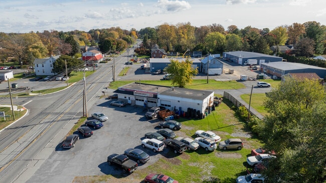
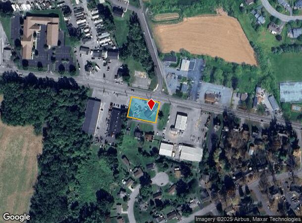
This Property Is For Sale
NEARBY LISTINGS FOR SALE OR LEASE
Property Detail
2720 Columbia Ave
410-87933-0-0000
2720 COLUMBIA AVE
Servicestation
Lancaster
X
Pennsylvania
42071C0342F
1
2024
0.50 AC
2025
Lancaster County
013703
Philadelphia
2,585 SF
Lancaster, PA
DEMOGRAPHICS near 2720 Columbia Ave
1 Mile
3 Mile
5 Mile
2024 Total Population
3,756
56,697
164,944
2029 Population
3,819
57,485
167,446
Pop Growth 2024-2029
+ 1.68%
+ 1.39%
+ 1.52%
Average Age
45
42
40
2024 Total Households
1,699
22,096
62,945
HH Growth 2024-2029
+ 1.71%
+ 1.22%
+ 1.49%
Median Household Inc
$66,028
$89,443
$75,693
Avg Household Size
2.20
2.40
2.40
2024 Avg HH Vehicles
2.00
2.00
2.00
Median Home Value
$273,557
$314,694
$285,981
Median Year Built
1971
1981
1968
Nearby Places
Map Layers
Map Styles
 Street
 Aerial
- Restaurants
- Banks
- Shops
- Fitness
- Groceries
PUBLIC TRANSPORTATION
COMMUTER RAIL
Lancaster (Keystone Service - Amtrak, Pennsylvanian - Amtrak)
DRIVE
WALK
Distance
Lancaster (Keystone Service - Amtrak, Pennsylvanian - Amtrak)
10 min
4.7 mi
AIRPORT
Harrisburg International
DRIVE
WALK
Distance
Harrisburg International
42 min
30.7 mi
Freight Ports
Port of Wilmington, RI
DRIVE
WALK
Distance
Port of Wilmington, RI
101 min
69.0 mi
Nearby Properties
Address
Land Use
TOTAL SIZE
Lot Size
Zoning
Address
Land Use
TOTAL SIZE
Lot Size
Zoning
822,920 SF
97.54 AC
HCD
Address
Land Use
TOTAL SIZE
Lot Size
Zoning
1,603,151 SF
104.89 AC
C3
Address
Land Use
TOTAL SIZE
Lot Size
Zoning
526,898 SF
26.10 AC
AH
Address
Land Use
TOTAL SIZE
Lot Size
Zoning
1,003,686 SF
127.66 AC
HR
Address
Land Use
TOTAL SIZE
Lot Size
Zoning
243,960 SF
39.27 AC
Address
Land Use
TOTAL SIZE
Lot Size
Zoning
941,905 SF
141.50 AC
I
Address
Land Use
TOTAL SIZE
Lot Size
Zoning
905,200 SF
68.60 AC
Address
Land Use
TOTAL SIZE
Lot Size
Zoning
224,054 SF
71 AC
Address
Land Use
TOTAL SIZE
Lot Size
Zoning
308,727 SF
11.37 AC
Address
Land Use
TOTAL SIZE
Lot Size
Zoning
193,864 SF
9 AC
Address
Land Use
TOTAL SIZE
Lot Size
Zoning
269,890 SF
57.10 AC
SR
Address
Land Use
TOTAL SIZE
Lot Size
Zoning
135,998 SF
28.64 AC
HR
Address
Land Use
TOTAL SIZE
Lot Size
Zoning
691,290 SF
3 AC
Address
Land Use
TOTAL SIZE
Lot Size
Zoning
372,708 SF
50.40 AC
HR
Address
Land Use
TOTAL SIZE
Lot Size
Zoning
128,939 SF
27.39 AC
Address
Land Use
TOTAL SIZE
Lot Size
Zoning
101,558 SF
28.14 AC
AH
Address
Land Use
TOTAL SIZE
Lot Size
Zoning
199,107 SF
26.20 AC
CC
Address
Land Use
TOTAL SIZE
Lot Size
Zoning
138,618 SF
9.53 AC
Address
Land Use
TOTAL SIZE
Lot Size
Zoning
299,600 SF
63 AC
HR
Address
Land Use
TOTAL SIZE
Lot Size
Zoning
244,568 SF
8.30 AC
IN
Address
Land Use
TOTAL SIZE
Lot Size
Zoning
113,967 SF
13.32 AC
Address
Land Use
TOTAL SIZE
Lot Size
Zoning
75,766 SF
9.07 AC
Address
Land Use
TOTAL SIZE
Lot Size
Zoning
826,042 SF
57.40 AC
CM
Address
Land Use
TOTAL SIZE
Lot Size
Zoning
97,158 SF
16.55 AC
R-2
Address
Land Use
TOTAL SIZE
Lot Size
Zoning
158,689 SF
25.40 AC
B-4
Address
Land Use
TOTAL SIZE
Lot Size
Zoning
237,347 SF
15.88 AC
I-1
Address
Land Use
TOTAL SIZE
Lot Size
Zoning
109,347 SF
12.70 AC
C-3
Address
Land Use
TOTAL SIZE
Lot Size
Zoning
137,650 SF
22.30 AC
I-1
Address
Land Use
TOTAL SIZE
Lot Size
Zoning
79,715 SF
11.61 AC
Address
Land Use
TOTAL SIZE
Lot Size
Zoning
330,951 SF
19.62 AC
I-2
The World's #1 Commercial Real Estate Marketplace
Connect with us
© 2025 CoStar Group
The information above has been obtained from sources believed reliable. While we do not doubt its accuracy we have not verified it and make no guarantee, warranty or representation about it. It is your responsibility to independently confirm its accuracy and completeness. Any projections, opinions, assumptions, or estimates used are for example only and do not represent the current or future performance of the property. The value of this transaction to you depends on tax and other factors which should be evaluated by your tax, financial, and legal advisors. You and your advisors should conduct a careful, independent investigation of the property to determine to your satisfaction the suitability of the property for your needs.