Property Record
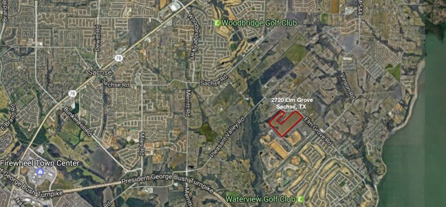
2720 Elm Grove Rd, Wylie, TX 75098
NEARBY LISTINGS FOR SALE OR LEASE
Property Detail
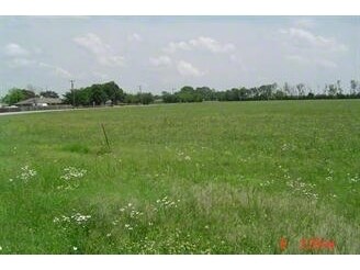
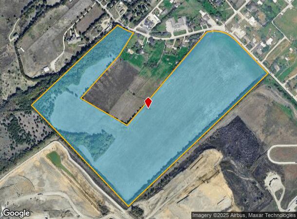
2720 Elm Grove Rd
Dallas-Fort Worth-Arlington, TX
F T Gaines
65049709510180000
F T GAINES ABST 497 PG 095 TRS 18, 20 & 23 ACS 74.317 INT202000208521 DD07312020 CO-DC 0497095101800 2CK04970951
Commercialacreage
Dallas
X
Texas
48113C0235K
74.32 AC
0
Garland
2025
Dallas/Ft Worth
018143
DEMOGRAPHICS near 2720 Elm Grove Rd
1 Mile
3 Mile
5 Mile
2024 Total Population
2,035
56,728
175,230
2029 Population
2,018
62,502
198,787
Pop Growth 2024-2029
(0.84%)
+ 10.18%
+ 13.44%
Average Age
36
37
38
2024 Total Households
694
17,920
56,923
HH Growth 2024-2029
(1.01%)
+ 10.23%
+ 13.42%
Median Household Inc
$108,686
$112,248
$107,403
Avg Household Size
2.90
3.10
3.00
2024 Avg HH Vehicles
2.00
2.00
2.00
Median Home Value
$349,438
$322,929
$297,788
Median Year Built
2004
2004
2001
Nearby Places
Map Layers
Map Styles
 Street
 Aerial
- Restaurants
- Banks
- Shops
- Fitness
- Groceries
PUBLIC TRANSPORTATION
AIRPORT
Dallas Love Field
DRIVE
WALK
Distance
Dallas Love Field
43 min
31.1 mi
Dallas-Fort Worth International
DRIVE
WALK
Distance
Dallas-Fort Worth International
49 min
39.1 mi
Freight Ports
Port of Shreveport
DRIVE
WALK
Distance
Port of Shreveport
220 min
199.3 mi
SALE & LEASE HISTORY
LISTING DATE
SALE/LEASE

Jul 06, 2017
For Sale
Aug 09, 2017
For Sale
Nearby Properties
Address
Land Use
TOTAL SIZE
Lot Size
Zoning
Address
Land Use
TOTAL SIZE
Lot Size
Zoning
350,553 SF
18.71 AC
MF-M
Address
Land Use
TOTAL SIZE
Lot Size
Zoning
328,843 SF
11.70 AC
Z239
Address
Land Use
TOTAL SIZE
Lot Size
Zoning
361,965 SF
11.12 AC
Z06
Address
Land Use
TOTAL SIZE
Lot Size
Zoning
231,434 SF
11.27 AC
Z06
Address
Land Use
TOTAL SIZE
Lot Size
Zoning
367,458 SF
13.42 AC
Address
Land Use
TOTAL SIZE
Lot Size
Zoning
320,801 SF
10.14 AC
Z236
Address
Land Use
TOTAL SIZE
Lot Size
Zoning
250,602 SF
4.99 AC
Z01
Address
Land Use
TOTAL SIZE
Lot Size
Zoning
423,253 SF
30.26 AC
Z239
Address
Land Use
TOTAL SIZE
Lot Size
Zoning
266,957 SF
11.34 AC
MFR
Address
Land Use
TOTAL SIZE
Lot Size
Zoning
366,600 SF
8.09 AC
Z06
Address
Land Use
TOTAL SIZE
Lot Size
Zoning
393,054 SF
55.95 AC
Address
Land Use
TOTAL SIZE
Lot Size
Zoning
286,659 SF
9.94 AC
Z236
Address
Land Use
TOTAL SIZE
Lot Size
Zoning
259,280 SF
5.15 AC
Z01
Address
Land Use
TOTAL SIZE
Lot Size
Zoning
228,536 SF
10.54 AC
MF-M
Address
Land Use
TOTAL SIZE
Lot Size
Zoning
60,593 SF
35.93 AC
Z06
Address
Land Use
TOTAL SIZE
Lot Size
Zoning
223,052 SF
5.81 AC
Z236
Address
Land Use
TOTAL SIZE
Lot Size
Zoning
420,500 SF
33.25 AC
Address
Land Use
TOTAL SIZE
Lot Size
Zoning
85,793 SF
6.90 AC
Address
Land Use
TOTAL SIZE
Lot Size
Zoning
261,000 SF
1 AC
Z318
Address
Land Use
TOTAL SIZE
Lot Size
Zoning
83,296 SF
14.88 AC
Z01
Address
Land Use
TOTAL SIZE
Lot Size
Zoning
97,898 SF
10.82 AC
Address
Land Use
TOTAL SIZE
Lot Size
Zoning
133,111 SF
2.73 AC
Z06
Address
Land Use
TOTAL SIZE
Lot Size
Zoning
67,677 SF
3.88 AC
Z06
Address
Land Use
TOTAL SIZE
Lot Size
Zoning
145,268 SF
16.34 AC
Address
Land Use
TOTAL SIZE
Lot Size
Zoning
221,982 SF
17.21 AC
Address
Land Use
TOTAL SIZE
Lot Size
Zoning
140,000 SF
12.76 AC
Address
Land Use
TOTAL SIZE
Lot Size
Zoning
141,200 SF
10.81 AC
Address
Land Use
TOTAL SIZE
Lot Size
Zoning
134,050 SF
5.01 AC
Z335
Address
Land Use
TOTAL SIZE
Lot Size
Zoning
147.23 AC
Z114
Address
Land Use
TOTAL SIZE
Lot Size
Zoning
79,346 SF
10.42 AC
The World's #1 Commercial Real Estate Marketplace
Connect with us
© 2025 CoStar Group
The information above has been obtained from sources believed reliable. While we do not doubt its accuracy we have not verified it and make no guarantee, warranty or representation about it. It is your responsibility to independently confirm its accuracy and completeness. Any projections, opinions, assumptions, or estimates used are for example only and do not represent the current or future performance of the property. The value of this transaction to you depends on tax and other factors which should be evaluated by your tax, financial, and legal advisors. You and your advisors should conduct a careful, independent investigation of the property to determine to your satisfaction the suitability of the property for your needs.