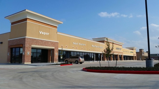
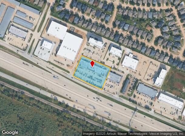
Property Record
27200 Highway 290, Cypress, TX 77433
NEARBY LISTINGS FOR SALE OR LEASE
Property Detail
27200 Highway 290
1301600010011
U S Highway 290 At Mueschke Reserve
Storebuilding
RES A9 BLK 1 U S HIGHWAY 290 AT MUESCHKE RESERVE
X
Harris
48201C0405M
Texas
2024
2.10 AC
2025
Fairfield
555701
Houston
20,214 SF
Houston-The Woodlands-Sugar Land, TX
DEMOGRAPHICS near 27200 Highway 290
1 Mile
3 Mile
5 Mile
2024 Total Population
7,580
60,226
137,760
2029 Population
7,732
61,630
140,966
Pop Growth 2024-2029
+ 2.01%
+ 2.33%
+ 2.33%
Average Age
34
36
36
2024 Total Households
2,386
18,834
43,097
HH Growth 2024-2029
+ 1.97%
+ 2.33%
+ 2.27%
Median Household Inc
$97,410
$118,342
$124,640
Avg Household Size
3.20
3.20
3.20
2024 Avg HH Vehicles
2.00
2.00
2.00
Median Home Value
$266,505
$320,437
$343,983
Median Year Built
2007
2007
2008
Nearby Places
Map Layers
Map Styles
 Street
 Aerial
- Restaurants
- Banks
- Shops
- Fitness
- Groceries
PUBLIC TRANSPORTATION
AIRPORT
George Bush Intcntl/Houston
DRIVE
WALK
Distance
George Bush Intcntl/Houston
42 min
29.4 mi
Freight Ports
Port of Houston
DRIVE
WALK
Distance
Port of Houston
52 min
38.2 mi
SALE & LEASE HISTORY
LISTING DATE
SALE/LEASE

Sep 25, 2016
For Lease
Mar 25, 2022
For Sale
Jun 24, 2021
For Sale
Jun 16, 2022
For Lease
Jul 26, 2023
For Lease
Jul 01, 2020
For Lease
Aug 19, 2025
For Lease
Apr 04, 2022
For Lease
Nearby Properties
Address
Land Use
TOTAL SIZE
Lot Size
Zoning
Address
Land Use
TOTAL SIZE
Lot Size
Zoning
621,523 SF
66.99 AC
Address
Land Use
TOTAL SIZE
Lot Size
Zoning
270,794 SF
30.38 AC
Address
Land Use
TOTAL SIZE
Lot Size
Zoning
443,219 SF
24.05 AC
Address
Land Use
TOTAL SIZE
Lot Size
Zoning
297,044 SF
15 AC
Address
Land Use
TOTAL SIZE
Lot Size
Zoning
321,055 SF
13.58 AC
Address
Land Use
TOTAL SIZE
Lot Size
Zoning
400,863 SF
17.46 AC
Address
Land Use
TOTAL SIZE
Lot Size
Zoning
300,268 SF
14.85 AC
Address
Land Use
TOTAL SIZE
Lot Size
Zoning
277,343 SF
12.79 AC
Address
Land Use
TOTAL SIZE
Lot Size
Zoning
290,379 SF
17.81 AC
Address
Land Use
TOTAL SIZE
Lot Size
Zoning
172,309 SF
Address
Land Use
TOTAL SIZE
Lot Size
Zoning
237,172 SF
35.93 AC
Address
Land Use
TOTAL SIZE
Lot Size
Zoning
235,555 SF
9.74 AC
Address
Land Use
TOTAL SIZE
Lot Size
Zoning
146,280 SF
4.21 AC
Address
Land Use
TOTAL SIZE
Lot Size
Zoning
269,329 SF
5.18 AC
Address
Land Use
TOTAL SIZE
Lot Size
Zoning
961,283 SF
105.37 AC
Address
Land Use
TOTAL SIZE
Lot Size
Zoning
168,517 SF
7.24 AC
Address
Land Use
TOTAL SIZE
Lot Size
Zoning
150,361 SF
16.70 AC
Address
Land Use
TOTAL SIZE
Lot Size
Zoning
146,694 SF
6.45 AC
Address
Land Use
TOTAL SIZE
Lot Size
Zoning
119,152 SF
12.56 AC
Address
Land Use
TOTAL SIZE
Lot Size
Zoning
266,820 SF
4.46 AC
Address
Land Use
TOTAL SIZE
Lot Size
Zoning
119,810 SF
14.25 AC
Address
Land Use
TOTAL SIZE
Lot Size
Zoning
154,676 SF
17.13 AC
Address
Land Use
TOTAL SIZE
Lot Size
Zoning
93,021 SF
15.16 AC
Address
Land Use
TOTAL SIZE
Lot Size
Zoning
81,933 SF
9.38 AC
Address
Land Use
TOTAL SIZE
Lot Size
Zoning
267,645 SF
14.20 AC
Address
Land Use
TOTAL SIZE
Lot Size
Zoning
100,827 SF
16.51 AC
Address
Land Use
TOTAL SIZE
Lot Size
Zoning
209,305 SF
21.77 AC
Address
Land Use
TOTAL SIZE
Lot Size
Zoning
1,207.31 AC
Address
Land Use
TOTAL SIZE
Lot Size
Zoning
116,800 SF
9.99 AC
Address
Land Use
TOTAL SIZE
Lot Size
Zoning
66,412 SF
8.43 AC
The World's #1 Commercial Real Estate Marketplace
Connect with us
© 2025 CoStar Group
The information above has been obtained from sources believed reliable. While we do not doubt its accuracy we have not verified it and make no guarantee, warranty or representation about it. It is your responsibility to independently confirm its accuracy and completeness. Any projections, opinions, assumptions, or estimates used are for example only and do not represent the current or future performance of the property. The value of this transaction to you depends on tax and other factors which should be evaluated by your tax, financial, and legal advisors. You and your advisors should conduct a careful, independent investigation of the property to determine to your satisfaction the suitability of the property for your needs.