Property Record
27202 Road 148, Visalia, CA 93292

NEARBY LISTINGS FOR SALE OR LEASE
Property Detail
27202 Road 148
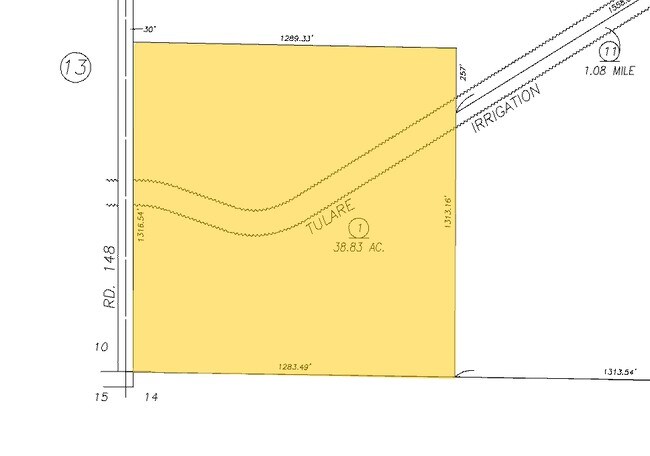
127-080-001-000
SW/4 OF SW/4 11-19-25 EXRD
Orchard
Tulare
X
California
06107C0965E
38.83 AC
2024
SW Outlying Tulare County
2025
Visalia/Porterville
001305
Visalia-Porterville, CA
DEMOGRAPHICS near 27202 Road 148
1 Mile
3 Mile
5 Mile
2024 Total Population
564
31,703
89,908
2029 Population
587
32,924
93,102
Pop Growth 2024-2029
+ 4.08%
+ 3.85%
+ 3.55%
Average Age
36
36
36
2024 Total Households
176
9,843
29,544
HH Growth 2024-2029
+ 3.98%
+ 3.84%
+ 3.54%
Median Household Inc
$34,166
$65,195
$62,427
Avg Household Size
3.20
3.20
3.00
2024 Avg HH Vehicles
2.00
2.00
2.00
Median Home Value
$416,667
$279,920
$271,598
Median Year Built
1983
1994
1983
Nearby Places
Map Layers
Map Styles
 Street
 Aerial
- Restaurants
- Banks
- Shops
- Fitness
- Groceries
PUBLIC TRANSPORTATION
AIRPORT
Fresno Yosemite International
DRIVE
WALK
Distance
Fresno Yosemite International
64 min
49.7 mi
Nearby Properties
Address
Land Use
TOTAL SIZE
Lot Size
Zoning
Address
Land Use
TOTAL SIZE
Lot Size
Zoning
47,768 SF
6.76 AC
RM2
Address
Land Use
TOTAL SIZE
Lot Size
Zoning
91,492 SF
4.80 AC
RM3
Address
Land Use
TOTAL SIZE
Lot Size
Zoning
126,532 SF
8.63 AC
RM2
Address
Land Use
TOTAL SIZE
Lot Size
Zoning
12.40 AC
Address
Land Use
TOTAL SIZE
Lot Size
Zoning
8,319 SF
19.68 AC
Address
Land Use
TOTAL SIZE
Lot Size
Zoning
38.34 AC
Address
Land Use
TOTAL SIZE
Lot Size
Zoning
3.45 AC
RM
Address
Land Use
TOTAL SIZE
Lot Size
Zoning
5,427 SF
1.95 AC
CSO
Address
Land Use
TOTAL SIZE
Lot Size
Zoning
57,025 SF
3.22 AC
GC
Address
Land Use
TOTAL SIZE
Lot Size
Zoning
19,967 SF
6.69 AC
AE20
Address
Land Use
TOTAL SIZE
Lot Size
Zoning
6,800 SF
2.08 AC
Address
Land Use
TOTAL SIZE
Lot Size
Zoning
71.25 AC
Address
Land Use
TOTAL SIZE
Lot Size
Zoning
12.38 AC
CSO
Address
Land Use
TOTAL SIZE
Lot Size
Zoning
2,836 SF
7.28 AC
PD-C-3-SC
Address
Land Use
TOTAL SIZE
Lot Size
Zoning
31,487 SF
4.87 AC
CG
Address
Land Use
TOTAL SIZE
Lot Size
Zoning
13.66 AC
AE20
Address
Land Use
TOTAL SIZE
Lot Size
Zoning
40,755 SF
3.77 AC
CSO
Address
Land Use
TOTAL SIZE
Lot Size
Zoning
17,570 SF
1.56 AC
CN
Address
Land Use
TOTAL SIZE
Lot Size
Zoning
780 SF
1.97 AC
CSO
Address
Land Use
TOTAL SIZE
Lot Size
Zoning
8.34 AC
IL
Address
Land Use
TOTAL SIZE
Lot Size
Zoning
8,499 SF
1.63 AC
PA
Address
Land Use
TOTAL SIZE
Lot Size
Zoning
3,746 SF
0.70 AC
CN
Address
Land Use
TOTAL SIZE
Lot Size
Zoning
7,666 SF
0.22 AC
CSO
Address
Land Use
TOTAL SIZE
Lot Size
Zoning
56,060 SF
3.64 AC
Address
Land Use
TOTAL SIZE
Lot Size
Zoning
17,156 SF
0.72 AC
PF
Address
Land Use
TOTAL SIZE
Lot Size
Zoning
16,676 SF
6.44 AC
QP
Address
Land Use
TOTAL SIZE
Lot Size
Zoning
0.75 AC
PA
Address
Land Use
TOTAL SIZE
Lot Size
Zoning
10,628 SF
1.14 AC
PA
Address
Land Use
TOTAL SIZE
Lot Size
Zoning
16,165 SF
9.08 AC
R-1-6
Address
Land Use
TOTAL SIZE
Lot Size
Zoning
18,868 SF
3.88 AC
R-1-6
The World's #1 Commercial Real Estate Marketplace
Connect with us
© 2025 CoStar Group
The information above has been obtained from sources believed reliable. While we do not doubt its accuracy we have not verified it and make no guarantee, warranty or representation about it. It is your responsibility to independently confirm its accuracy and completeness. Any projections, opinions, assumptions, or estimates used are for example only and do not represent the current or future performance of the property. The value of this transaction to you depends on tax and other factors which should be evaluated by your tax, financial, and legal advisors. You and your advisors should conduct a careful, independent investigation of the property to determine to your satisfaction the suitability of the property for your needs.